
Hiking Looking Glass Rock
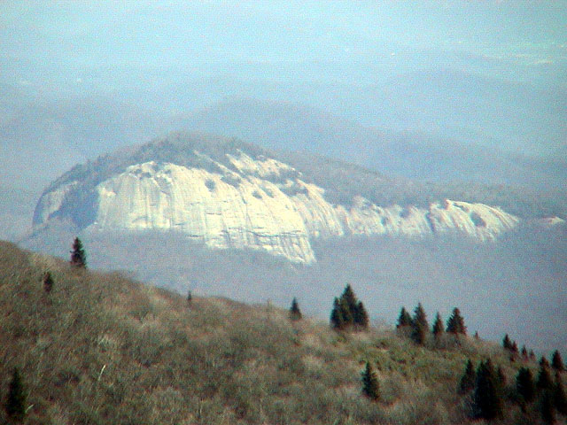
Image: by Wayne Busch- View of Looking Glass Rock from the Blue Ridge Parkway
You may have seen this view of Looking Glass Rock from the Blue Ridge Parkway at Milepost 417, south of Mount Pisgah and near Graveyard Fields. The stone face looks impossible to hike, and you sometimes see professional rock climbers on this impressive peak.
Good news! If you drive around to the other side of Looking Glass Rock in the Brevard area, you will find a very walkable trail to the top to enjoy the great views, looking back toward the Blue Ridge Parkway. The Looking Glass Rock Trail is extremely popular and can be a bit crowded on warm weather weekends. It's perfect for a winter hike. (Be careful of ice on the rock face at the top in cold weather.) It's only about 45 minutes from downtown Asheville.
The Looking Glass Rock Trail climbs about 1,700 feet in just over three miles (6.5 miles roundtrip, allow 4-5 hours). The many switchbacks along the way help make for a long, but only moderately difficult climb. The views from the top are well worth the effort. The trail is well blazed in yellow and easy to follow.
The trail starts off following a stream with some small cascades along the way, before beginning a series of switchbacks up the mountain. Sections of the trail takes you through tunnels of rhododendron and mountain laurel.
After about two miles, the trail reaches a flat rock area, which is used as a helicopter pad by the local rescue squad for injured rock climbers. This is a good resting spot. A spur trail heads off to the left past the helipad, which leads to some nice views from Lower Looking Glass Cliffs.
At the helipad, the main trail heads off to the right (follow yellow blazes) and continues its climb to the summit. There are a couple of nice campsites, but you can't see much from the actual summit. The trail continues past the summit and after a short descent you will arrive at Upper Looking Glass Cliffs where you will be treated to some spectacular views. Do not get too close to the edge! It is very easy to slip, and a fall from here would most certainly be fatal.
Image below: The start of the 3.2 mile climb to the top
 Directions from Downtown Asheville (about 36 miles):
Take I-240 West / I-26 East. Continue on I-26 East to Exit 40 for Highway 280 (and the Asheville Airport). Take a right onto Highway 280 West and go 16 miles toward Brevard. As you enter the Brevard area, you will see a big shopping center on the right (with Wal-Mart). Just past the center, turn right onto US Highway 276 North to enter the Pisgah National Forest. Go 5.3 miles and turn left at the sign for Pisgah Center for Wildlife Education and the State Fish Hatchery. Go 4/10 of a mile and look for the parking area on the right for Looking Glass Rock Trail Head. For more information about the many hiking trails in Pisgah National Forest, stop at their Visitors Center on US 276 on the way to the Trail Head.
Technorati Tags: [Blue Ridge Parkway][Looking Glass Rock][Mount Pisgah][Graveyard Fields][North Carolina][Brevard][Asheville][National Forest][Hiking][Trails]
posted by D L Ennis @ 11:00 AM
![]()


2 Comments:
At Friday, 10 February, 2006, Anonymous said…
Excellent shot!
At Saturday, 19 August, 2006, Anonymous said…
do you need hiking boots for the trail to looking glass rock
Post a Comment
<< Home