Whitewater Falls
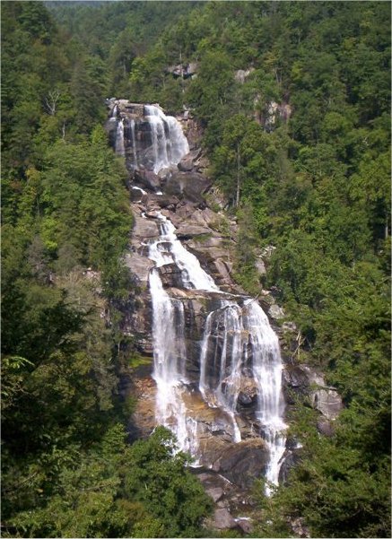
Whitewater's spectacular 411-foot plunge. Photo by JP Bode, over at WNCHiker. Check him out!
This is one of my favorite waterfalls of all that I have visited, over the years, anywhere in the US. It is absolutely beautiful!
Upper Whitewater Falls is the highest waterfall east of the Rockies. The falls plunge an amazing 411 feet! South Carolina's Lower Whitewater Falls drops another 400 feet. Because of the escarpment's difficult access and rugged terrain, much of the area receives few visitors and has remained wild and undeveloped over the years. In the cool, moist shade of steep slopes and rock cliffs, wildflowers and salamanders abound. This wild land is also a perfect haven for a rich array of ferns, mosses, and fungi. Enjoy the beauty of berries and blooms throughout the seasons.
Hours: Dawn until dusk, year-round.
Picnic tables: Yes
Restrooms: Yes
Fee: $2 for vehicles with seven passengers or less; $1 per person for more than seven people traveling together in a vehicle. Annual pass available for $15; One-day or season permits are also valid at Whiteside Mountain and at Dry Falls.
Camping: No
Where to find the best views: For an excellent view of Whitewater Falls, follow the paved walkway to the upper overlook. The walkway begins at the end of the parking lot and is accessible to wheelchairs. A lower overlook is located at the bottom of 154 wooden steps. More energetic hikers can continue down the half-mile spur trail that drops 600 feet in elevation to the Whitewater River and Foothills Trail. With the exception of the two overlooks near the top, no other views of the falls are offered.The best views of the falls are from the two overlooks. However, some people venture off the trail to try for better views. Tragically, several of these people fell to their deaths or suffered serious injuries at Whitewater Falls. Please stay on the trails.
The Foothills Trail stretches along the Blue Ridge Escarpment in North Carolina and South Carolina for 85 miles. After descending the spur trail, hikers may head east on the Foothills Trail to South Carolina, the Lower Whitewater Falls, and other eastward points. The majority of trail maintenance is provided by volunteers with the Foothills Trail Conference, whose board includes representatives of managing agencies and landowners. The Highlands Ranger district of the Nantahala National Forest manages a 4.5-mile segment of the Foothills Trail from the NC-SC State line east of Whitewater Falls to the NC-SC State line, west of the falls.
How to Get There
From Cashiers: Drive south on NC 107 for 9.3 miles. Shortly after crossing the State line, turn left at the sign for Whitewater Falls. Continue 2.3 miles to the intersection with SC 130, which becomes NC 281 at the North Carolina State line. Just beyond this point is a sign for the entrance to Whitewater Falls.
From Brevard: Drive west on U.S. 64. At Sapphire, turn left on NC 281 and go south to the Whitewater Falls entrance.
From South Carolina: Drive north on SC 130, which becomes NC 281. The Whitewater Falls entrance is on the right after driving into North Carolina.
From Walhalla, SC: Use SC 107 and cross over to SC 130 and NC 281.
From Asheville: Take 240-West to I26-West. Go to the Asheville Airport/Brevard Exit (exit 9) and take a right onto U.S. 64. Drive to Brevard and follow above directions.
Technorati Tags: [Blue Ridge][Whitewater Falls][North Carolina][South Carolina][Whiteside Mountain][Dry Falls][Nantahala][National Forest][Highlands][Cashiers][Brevard][Walhalla][Asheville][Trails][Hiking]
posted by D L Ennis @ 11:07 PM
![]()


3 Comments:
At Tuesday, 31 January, 2006, The MacBean Gene said…
Had to let you know how much I'm enjoying your site, E. L. Wish I had found it sooner.
At Tuesday, 31 January, 2006, Anonymous said…
I've passed your link onto a hiking friend. I hope she visits today to see this post.
At Tuesday, 31 January, 2006, D L Ennis said…
Thank you Macbean, I am equally enjoying yours I assure you!
Thanks Colleen! I can use all the help I can get.
DL
Post a Comment
<< Home