The Photography of D L Ennis, and more!


Tuesday, February 28, 2006

Spring? Sometimes You Just Need a Break!


Candy, last summer, on a blanket in the shade where I do my morning reading on hot summer days.

I was sitting here in my home office this morning, pouring over some research for a project I’m working on, when my constant companion “Candy”—the smallest of our five dogs—starts fussing for me to take her outside; I finally gave in!

So, we went out back to our full-sun garden and I laid down on the bench-swing watching the fluffy-pillows of clouds drift by while Candy did her thing.

The longer I lay there the more my senses came to life and I suddenly noticed that a Carolina Wren was serenading me from a near by holly. I sat up and let the warm morning sun bathe my face for a moment then opened my eyes and began looking around. The first thing my eyes noticed was the swelling buds on the Hickory and Bradford Pear trees.


Image left: Japanese quince; an early bloomer.

As I looked around the garden a beam of yellow dashed into my eyes and them pink; A Forsythia and Japanese quince was in bloom. I turned to look at the Dogwoods and the buds, sat last autumn, were still tightly wrapped, perched on the tips of their bare winter branches; ah, a false spring; it happens every year; I’m always trying to rush spring on during the waning days of winter!

But take heart, for there are only twenty days left until the first day of spring when the earth springs to life. So, if you can, do yourself a favor and take a few moments to enjoy a beautiful late winter day like today, here at my Blue Ridge Mountain home, where the temperature is sixty-something, it’s mostly sunny, and the birds are singing!

Monday, February 27, 2006

A Typical Mountain Woman

Part One: Rock Castle Gorge

Image: Edith Underwood and Ruby Underwood in Rock Castle

Ruby Underwood was born in 1913 in a little hollow of the Blue Ridge Mountains known as Rock Castle. She was the sixth of eight children born in a time of large families and small communities of subsistence farms. Her life spanned seventy-nine years of great change in the mountains that she called home.

Ruby's father, Samuel Henry Underwood, descended from Pennsylvania Quaker stock, independent thinkers that were churched for various reasons and left Pennsylvania for the freedom of the mountain frontier. Her mother, Addie Belcher, was of solid German descent. The Belchers were some of the first settlers in the Rock Castle community, with early deeds showing their presence shortly after Patrick County was formed.

Rock Castle, now known as Rock Castle Gorge and National Park Service property, possibly was named after the quartz rocks that are found in the area. Some think that "Rock Castle" is a corruption of "Rock Crystal". Others think that the name came from the bare rock cliffs that show in the side of the mountain; looking up at them a fanciful nature might think that they looked like stone castles. The community was large enough in 1861 to appear on a railroad map printed at the time, while other communities, including Meadows of Dan, were left off. Oddly enough, there was no railroad through the area, but the 'main road' on that side of the mountain, a steep wagon trail winding up the mountain, went through Rock Castle.

Ruby grew up in a community of farmers that were nearly all related to her; those families not related had lived side by side for generations. Stories of life down in Rock Castle reveal a close-knit community. Gatherings at the Bear (or Bare) Rocks, a large tumble of huge boulders that thrust out of the mountains, included picnics for the entire community, singing, exploring of caves and a little courting while children scrambled over stones and into crevices with an abandon unknown in today's world. There was a cave somewhere in the rocks, or nearby in the mountains, where the local explorers wrote or carved names and quotations. There was the "Potato Hill" named for its shape or the fact that potatoes grew well there. Rock Castle Creek tumbled down the mountain, usually in sight of the main road.

Sam Underwood's two story frame house stood above Rock Castle Creek, surrounded by gardens, pastures and outbuildings. A Delco plant provided electricity for lights in the house and a large stone chimney with fireplaces and cookstoves provided warmth. Ruby and her sisters helped with the cooking, tending the chickens and gardening, while her older brothers got out early to tackle heavier chores. All of the children helped with getting in the hay, and Ruby, as the smallest, was sent atop the haystack to stamp the hay down as it was pitchforked up. The hay had to be stacked with particular care, and Ruby remembered how itchy and hot the job was, clinging to the pole in the middle and marching around on top of the slippery hay as the stack rose higher beneath her bare feet.

Apple orchards also surrounded the houses and apples were stored in cellars, along with potatoes and onions, or dried for the winter. Before the chestnut blight devastated the mountains and robbed the settlers of the rich bounty of the chestnut tree, the children were sent out to gather the chestnuts to be sold for cash money for necessities that couldn't be obtained on the farm. The money for Chestnuts provided sugar, coffee, and shoes for the children to wear to school in the winter. Thousands of pounds of chestnuts were shipped from Patrick County each year to markets in the Northern states.

Family was important to the people in the mountains, who still count kin as far away as fifth or sixth cousins. Ruby's large extended family included uncles and cousins that lived down in the mountain as well as more distant kin in the surrounding hills. Ruby's grandfather, Reed Belcher, was a Civil War veteran. When she was small Addie and her sister took turns caring for the old man, bringing him up and down the mountain with the seasons. Ruby remembered them sitting him up in his rocking chair in the farm wagon to transport him from house to house.

Reed Belcher's story was one that is remembered by the family. He and at least one of his brothers went into service with the Confederate army, but their father kept one or two of the boys at home, either because he needed the help or he felt that he had risked enough with sending the boys that had gone. There are conflicting versions of this tale, but Ruby's story is partly supported by documentation. A Confederate conscription force came through Rock Castle "hunting for Belchers", according to the Confederate captain's diary. They found the old man at home but the boys had fled into the rhododendron thickets and were well hidden. One version of the tale has the mother of the children flinging a dipper of water in the captain's face when he demanded refreshment for his troops. Most versions agree that when the troops couldn't locate the elusive Belcher boys, they 'strung up' the old man from a tree in the yard by his neck. Apparently they just pulled him up in the tree to strangle, rather than actually hanging him and breaking his neck. The boys were nearby and with their mother were able to rescue their father.

Image: Alfred Underwood family, including Sam Underwood

When Reed heard the story, he was so disgusted he quit the Confederate army and went to Ohio, joining up with the Union force. It's said that there was some family feeling about the situation. Reed received a small pension, while other members of the family that had fought for the Confederate forces didn't qualify. Ruby said that to tease the old man the older boys would sing "Dixie" to infuriate him.

Henry Dillon was a neighbor who taught a school in the area and acted as an unofficial doctor during emergencies. He said he obtained his education from reading whatever books he could get his hands on. He and Sam Underwood had a good bit in common; Sam was a reader and subscribed to the Atlanta Constitution, which couldn't be touched by anyone else until he read it. His children were all great readers, especially Ruby, who read the heavy newspaper even when she was too small to understand the stories. There were a few treasured books in the house, read over and over and shared with the children.

Another neighbor was a woman farmer who raised her children and kept the farm alone, with only the help that the neighborhood folks could spare her. She was well-respected as a hard worker and self-sufficient woman, and was called "Mrs." although she never married, as far as can be discovered. One of her sons stayed with her and took over the farm as she grew older, staying there with her until the Park Service purchased the land.

Ruby's early childhood years were spent deep in Rock Castle, where she was surrounded by family and friends and wealth in the form of a large and loving family to protect and provide for her. Necessary chores were done, even by small children, but there was plenty of time to play with cousins from up and down the mountain and to explore the creek and surrounding hills. Children invented their own games, toys were few and treasured but imagination was boundless.

To Be continued....


Technorati Tags:

Black Bear in the Blue Ridge Mountains


Image: Black Bear (Ursus americanus) courtesy of the National Park Service


With spring on its way bringing more people to our beautiful Blue Ridge Mountains to camp and hike, I thought that I would do a series on the black bear and how to camp and hike safely in black bear country.

This first segment is meant to familiarize you with the black bear; a little history, their look, range, and habits.

The North American black bear (Ursus americanus) is the best known and most widespread of North American bears. It is of medium size among bears, averaging 135 to 350 pounds, although individuals over 600 pounds have been found. Adult black bears, standing slightly over three feet at the shoulders, have a predominately black coat which is smooth and short haired, compared to the brown bears. However, there are also a number of well defined color variants: chocolate-brown, cinnamon and a silver gray tending to off-white. Smaller than their cousins, the black bear is an agile climber, even in adulthood. Black bears are alert creatures, with a sense of smell more highly developed than other large animals, with exceptional hearing but apparently only average eyesight.

The black bear originally inhabited the vast majority of our North American forest. Their numbers are estimated to have been about two million in the 1500's, but the black bear has been eliminated from many areas of the eastern, southeastern and central United States, and now, less than 200,000 are estimated to exist. Much of the range of the black bears is shared with the grizzly in parts of the northern Rockies, western Canada and Alaska. Although somewhat similar in coloration, in much of its habitat, the black bear does not have the noticeable front shoulder hump of the grizzly. The black bear has not been eliminated to the extent that the majestic grizzly bear has and is still found in a majority of the states, as well as all of the Canadian provinces and territories. It is a typical woodland animal and prefers forests with abundant undergrowth.

The black bear has become known to the public at large through the enormous popularity of US National Parks. As they are protected within the boundaries of the parks, some bears have lost their fear of man and will even go so far as to beg for handouts at the roadside. Other bears congregate around trash dumps or campsites and seize available food. Scarcity or abundance of natural food has much to do with black bear behavior. Not only will a black bear eat almost anything, it will gorge itself until its stomach can hold no more, sleep it off, and start the process over again.

Black bears are solitary animals that wander all their lives in search of food. The black bear's diet is similar to that of the brown bears, omnivores who will eat almost anything, but it is more markedly herbivorous. Depending on the season and the environment, vegetative matter makes up between 80% and 95% of its diet. During the spring (April-May) black bears feed mainly on grasses. Appearing to wander aimlessly, black bears are always in search of a more plentiful source of food or a mate during breeding season. In June they add insects, grubs and ants to their diet and in the fall the main source of foods are berries, mushrooms and acorns with supplemental carrion when available. Fall is a critical period as far as nutrition is concerned, in that sufficient reserves of fat must be built up for the winter. This is particularly important for those females which are going to be suckling young during the winter retreat.

The next segment of this series will be online next Monday 03/06/ 2006.


Please, when you go into our forest and National Parks leave nothing but footprints and take nothing but photos and wonderful memories!

All of us here at the Blue Ridge Gazette appreciate all of our readers very much and we hope you continue to visit us and continue tell your friends…Thanks!


Technorati Tags:

Saturday, February 25, 2006

Out of the Blue Zone-Yellowstone & Grizzly Bears


Image: Yellowstone National Park Hayden Valley - Mt Washburn

Out of the Blue Zone is a new feature on the Blue Ridge Gazette. We will take a look at things going on in other regions of our natural world. Today, Yellowstone National Park, the grizzly bear and Congressional attacks on the Endangered Species Act.

We as citizens and guardians of our natural world must take issue with the Bush Administration's proposal to remove the grizzly bears, in and around Yellowstone National Park, from the list of endangered and threatened animals as well as recent Congressional attacks on the Endangered Species Act.

Now the U.S. Fish and Wildlife Service could be deciding the fate of the grizzly bear as soon as March 17 which we must act now!

The grizzly bear is an irreplaceable part of America's natural heritage, a symbol of the independence that defines the American character and an icon of all that is wild and free. Since 1975, the Endangered Species Act has worked to protect these magnificent animals.

For 30 years our country has invested tremendous time and energy into improving the chances of the grizzly bears' survival and that work has started to pay off, increasing the number of grizzlies in the U.S. from a meager 150 to about 600 today.

Delisting grizzly bears at a time when their population is still so small and their range is so limited could have devastating effects and we can't let that happen!

So Please, Act Now, Show Your Support for Delisting Yellowstone Grizzly Bears by Contacting Your Representatives in Washington DC. I have already sent my letter and the National Wildlife Federation has made it easy for you to also; just click here.

If you can make a donation, make it to the National Wildlife Federation or the Sierra Club to help protect the grizzly bear.


Technorati Tags:

The Elusive Morel Mushroom


Image left: by D L Ennis, Morel Mushroom found in the Blue Ridge Mountains of Virginia.

Morels grow in temperate latitudes around the world, in both conifer and hardwood forests. In North America they usually emerge first along the West coast in Early Spring and later in much of the forested East, from the Appalachians up through the Great Lakes region, with scattered harvests into Summer and Fall months.

Morels are among the most highly prized of all the wild mushrooms. The reason is plain; their taste is superb!

They evolved from a “yeast” so recently that they have not acquired a high degree of structural complexity. It is interesting that the morel is in the process of evolving from a single celled organism (a yeast) into a multicelled organism. This hasn't happened in hundreds of millions of years, and now the process is observable having begun about 50,000 years ago for the morel and continuing.

Morels grow primarily in sandy soil, never clay, unless there is a lot of organic matter near the surface. Therefore, they are usually found near rivers. They are also found scattered widely in mountain humus. They never grow in bog, because water seals out oxygen.

The habitat is usually tall trees in undisturbed environments, though morels are sometimes found in brush. In clean sand, they tend to wander some distance from trees. They sometimes come up in tall grass.

Timing is critical in finding morels. They come up about six weeks after the ground thaws. It might be eight weeks, if dry weather slows down their growth.

This means early April in the Blue Ridge Mountains, late April in Iowa and middle of May in northern Michigan. Experienced morel stalkers check an environment several times starting early and after every rain.

Morels usually come up after a rain. The day after a rain is the best time to look for them. They will still be in good shape for 3-5 days, if someone else doesn't get to them. In about a week, they start to break down, and bacteria grow on them, which will make a person sick. So don't eat morels which are old and starting to break down.

Sometimes, morels will come up in flushes each time a rain occurs. Sometimes, they will come up without a rain, but they will then be delayed a couple of weeks.

Morels are not found in the same place for more than one to three years, because they use up the type of nutrients that they require, which is a particular type of bacteria.

The best way to spread morel spores is to put the old ones on tree branches. Only the old ones have mature spores. The young ones will dry before spores are formed.


Image right: by George Barron, University of Guelph, Canada. Saddle-backed False Morel- Helvella crispa

Be careful of false morels, sometimes called brain mushrooms. They produce a toxin. It is usually not lethal in this country but should be avoided. False morels are rounder and lower to the ground, and the ridges are more rounded, like brains.

Be careful about storing morels a long time before eating, unless they are dried or precooked and frozen. Otherwise, bacteria grow on them, which can make a person sick, but not seriously ill. The bacteria are probably Psuedomonads. Store in paper bags, which absorb moisture, but avoid plastic, which causes moisture to accumulate.

Even when cooking kills bacteria, it leaves a moderately problematic endotoxin with gram negative bacteria, which grow on morels. Endotoxin is a lipid complex in the cell walls of all gram negative bacteria. It's the most common problem with food spoilage.

For recipes and more about the Morel Mushroom click here.

Technorati Tags:

Mountain Meadow Farm and Craft Market

Sammy and Sue
Sammy and Sue Shelor

Sue Shelor was born and raised in Connecticut, but her whole life changed when she met southern boy Sammy Shelor. Sue first met Sammy in 1997, in Connecticut, and a month later they saw each other again at a Pennsylvania bluegrass festival. Sammy Shelor is a well-known bluegrass musician, heading up the Lonesome River Band.

Single mom and Hunter
Sue and her young son, Hunter

Sue was a single mom with one son, Hunter, with family connections in Connecticut. She owned a business in Connecticut that was successful and enjoyed being independent. The long distance part of the relationship with Sammy, 600 miles from one driveway to the other, lasted two and a half years.

Sammy and his grandfather
Sammy Shelor and Cruise Howell, his grandfather

Sammy was born and raised in the Blue Ridge Mountains of Virginia, in a small community where his ancestors had settled for generations. From the time he was five years old he had been playing bluegrass banjo, with the encouragement and support of his family, especially his two grandfathers, William Cruise Howell and Sandy Samuel Shelor. Cruise Howell was a banjo player and had come from a family of mountain musicians. Sammy's career has spanned decades of success, with four consecutive International Bluegrass Musicians' Association Banjo Player of the year awards and numerous SPBGMA awards. The Lonesome River Band appears at festivals nationally and internationally, and the central location of Sammy's Meadows of Dan home, close to Nashville and his roots, prevented his considering a move to Connecticut when his relationship with Sue became more serious. After much discussion and persuasion on Sammy's part, Sue and her young son moved to Virginia. In a small country church near their new home, with family and friends and bluegrass music, Sammy and Sue were married in September of 2000.


The farm in Meadows of Dan

After the death of Sammy's paternal grandfather, Sandy Shelor, Sammy inherited the 22 acre farm where Sandy spent the largest portion of his 96 years. This lovely piece of property is located in the small community of Meadows of Dan, just off the Blue Ridge Parkway and at the intersection of Squirrel Spur Road and Highway 58. Sammy's career is demanding and he spends much of his time on the road and promoting LRB, as well as in the studio with other projects. Sammy and Sue both realized the potential of the family property as a means of improving the local economy and promoting Sue's business, Mountain Meadow Crafts. She opened the Mountain Meadow Farm and Craft Market in the summer of 2005, with a very successful craft and music festival. At the market local farmers and crafters have an opportunity to showcase their talents to the appreciative scores of tourists that come to Meadows of Dan from the Blue Ridge Parkway throughout the season.

Happy Crowd at the Chinquapin Festival
Chinquapin Festival

The Mountain Meadow Farm and Craft Market has been a great success, with monthly festivals that include music, crafts, fresh local produce and other activities. Sue is continually working on new ideas for her venture, adding activities and promotions that keep the tourists and the locals coming back for more. Her large tent will be replaced soon with a permanent pavilion, and eventually there are plans for a shop on the property for crafters to rent booth space for their quality hand crafted items. The Market is located on The Crooked Road, the music heritage trial through Southwestern Virginia. The first Meadows of Dan Corn Maze will showcase The Crooked Road logo.

Sue in her shop
Sue in her shop

Sue's business, Mountain Meadow Crafts, began when she became interested in crafting with gourds. While Sammy's gifts are musical, artistic talent runs in her family. Sue's mother is a fabulous painter, while she has a sister that's creative genius graces everything she touches. A brother is a talented woodworker and makes fine handmade furniture. Sue had dabbled with ceramics, batiking, and pencil drawing in her younger days, before the demands of motherhood and making a living took up her time.

Sue's artistic talents emerged with this new medium and she was on her way, using natural materials, woodburning, carving and other techniques to create beautiful gourd art. She has created over one hundred unique pieces, and she spends every hour she can manage in her shop, creating unusual one-of-a-kind items ranging from birdhouses to decorative items for the home.

Lucky Dog in the shop
Lucky in the studio

Cheerful dog Lucky often keeps Sue company in her studio, set up in a small building near the main house. Sue discovered that with a busy and active family, having her own space to create her specialty art was vital to her craft. Books on Tape are a favorite accompaniment to her work, or music as she assembles her pieces from an extensive collection of natural materials ranging from pine needles to shells. It's not uncommon for one of the family's three cats to wander in, stroll across the work table and then settle in to watch for a time.

Curious Kitty
Visitor to the shop

Sue finds her inspiration in the surrounding beauty of the beautiful Blue Ridge Mountains she now calls home. She and Hunter spend time wandering through the woods, searching for unique embellishments to enhance her lovely gourd creations. Sharing the unique heritage and natural beauty of Meadows of Dan is a goal that Sammy and Sue Shelor share, and they invite everyone to come and visit the beautiful and special little community, just off the Blue Ridge Parkway between milepost 178 and 177, right on U. S. Highway 58. Visitors will find scenic views, beautiful Bed and Breakfast homes, the well-known and beautiful rock churches of Robert Childress fame, historic sites such as Mabry's Mill, and wonderful trails to hike and explore.

The Mountain Meadow Farm and Craft Market is currently open on weekends from April to October. Located in Meadows of Dan, just off the Blue Ridge Parkway near the intersection with Highway 58, on Concord Road. Hours are 10 AM to 5 PM. Watch the Blue Ridge Gazette calendar for information about monthly festivals.

Technorati Tags:

Friday, February 24, 2006

On a Mid-Winters Eve


On a mid-winters eve, in the Blue Ridge Mountains of Virginia, I walk the dirt road that ends at my house, looking, listening, hearing and breathing in all that nature offers me. A dove in the distance coos as two lithely take to wing on a whistle from the tall burnt-gold grass that borders the road. Horses whinny as I pass the field where they feed, watching me like a dog guarding his food bowl.

On the northern wind blows a chill electrifying all living things, even I have more spring in my step.

The mountains in the distant blue; the darkened wood adorned in evergreen, bejeweled with pools of sun adrift on the winds tide as day flows west.

As I turn onto an adjoining road, the soiled gravel beneath my feet, harsh in contrast to all that my senses -now in full bloom- contemplate, a young whitetail doe, harmlessly feeding on grass along the edge of the coppice, flees into the wind crossing my path no more than twenty feet in front of me. Her eyes large and the deepest of brown, holding such beauty and the wisdom of nature’s ways with an instinct of survival handed down from antediluvian ancestors. I pause to admire her tracks along the roads edge, a ritual I have performed since childhood. I cannot help but to marvel at this sign of presence left by such an amazing animal, this gift given us, an endowment, as is all life on this extraordinary planet.

If man would slow down, take notice and ponder with reason, genuinely trying to see the singularity and splendor that all of life upon this breathing orb -that we call earth- offers, how much more congenial this world would be to live in.

Another hundred yards beyond this place there joins another road bordering the land of a friend forty years my senior, and I am not a young man. Charlie Floyd, a teller of tales, both temperate and callous, has lived in these mountains for eighty-nine years and has more stories to tell than time to tell them. When time does permit, we sit beneath the tall pines over looking the hollow behind Charlie's small mobile home. There is a pond in this hollow filled with fish and loved by the local beavers and otters, migrating ducks and geese make their presence known in spring and fall.

On this day, the pond - in spite of the brisk northern wind, is as smooth as silk but for an occasional ripple, as a wisp of wind steals down the ridge to intrude upon the serenity of the lakes surface. We sit in hush, there will be no story told today exclusive of the one unfolding before our eyes. One should pause and allow their senses to guide them through the oldest story told on this earth, a story understood by few--nature’s story.

The day ends as dusk drapes this mid-winters day and I say farewell to Charlie and take the shortcut through the woods, back to the warmth of my Blue Ridge Mountain home, on a mid-winters eve.

Technorati Tags:

Thursday, February 23, 2006

American Indian Influence in the Blue Ridge


Spring is on its way, and as you travel the Blue Ridge Parkway this spring and summer, look for the ruminants of our Native American friends. The Blue Ridge Parkway extends nearly 500 miles along the crest of the Blue Ridge Mountains through North Carolina and Virginia; it encompasses some of the oldest settlements of pre-historic Native Americans.

The Cherokee Indians of North Carolina, and the Monacan and the now extinct, Saponi, and Tutelo Indians of western Virginia, were among the earliest inhabitants of the Blue Ridge, leaving artifacts and changes in the landscape as evidence of their existence.

Many of the fields that are still visible at the base of the mountains date back centuries, to ancient American Indian agricultural methods of burning and deadening the trees and underbrush to provide needed grazing and crop land. Mountain and river names along the Parkway also reflect the American Indian influence.

One of the best places to learn about the pre-history of the Appalachian chain in Virginia, is at the Peaks of Otter Visitor Center museum (milepost 85.9). Arrowheads and early tools found in the Peaks area are exhibited.

In North Carolina, the Parkway enters the Cherokee Indian Reservation at milepost 457.7 and features an informational display on the reservation at the Lickstone Overlook (milepost 458.9).

Images: by D L Ennis, Dancers at a Monacan Powwow

Attend the 14th Annual Monacan Powwow May 20 & 21, 2006. Click the link for more information.


Technorati Tags:

Friends of National Parks Steps Up

I recently did a post about the vandalism at the Gettysburg National Battlefield entitled “New Battle at Gettysburg.” Now Friends of National Parks in Gettysburg has established a $30,000 reward for information leading to the arrest and conviction of the person or persons responsible for the recent monument vandalism at Gettysburg National Military Park. The Friends reward is being offered in addition to any money offered by Adams County Crime Stoppers.

To establish the reward, the Friends teamed with the Gettysburg National Battlefield Museum Foundation, the Association of Licensed Battlefield Guides and the Gettysburg Civil War Round Table.

”We are devastated by this vandalism, and we’ve heard from people all over the country who are eager to help find the people responsible,” said Friends, Chair of the Board Barbara J. Finfrock. “The monuments were placed on these fields” as testaments to bravery and sacrifice “by the soldiers who fought here, and we are honored to stand with our partners to seek justice.”

Three monuments were severely vandalized last week: the 11th Massachusetts Volunteer Infantry monument, the 114th Pennsylvania Volunteer Infantry monument and the 4th New York battery (Smith’s battery) monument.

Anyone with information should call Gettysburg National Military Park at 717-334-0909 or the Adams County Crime Stoppers at 1-800-869-8057. Callers may remain anonymous. It is the Friends “mission on behalf of all generations of Americans” to honor, support, protect and enhance the resources associated with the Gettysburg National Military Park, the Battle of Gettysburg and the Eisenhower National Historic Site.

For more information about the Friends, call 717-334-0772 or visit Friends of Gettysburg.


Technorati Tags:

Wednesday, February 22, 2006

Introductions

Hello, my name is John. Since June 2005 I have been writing and editing A DC Birding Blog, in which I narrate my birding adventures and comment on environmental issues that affect the Mid-Atlantic region and the world. If you would like to learn more about my interests, I suggest that you check out my archives, starting with the posts I have linked in the left sidebar.

Earlier this week, DL Ennis, the proprietor of the Blue Ridge Gazette, invited me to join the team of bloggers he is putting together here. After giving it some thought, I gladly accepted. I am looking forward to learning more about the region and its natural history as I blog here.

Tags:

The 34th National Storytelling Festival


Image: Last years NSF brochure cover.

Now is the time to make plans for the 34th National Storytelling Festival, October 6-8, 2006 in Jonesborough, Tennessee! The festival begins Friday morning and continues through Sunday afternoon.

I know that it may seem a little early to be telling you about an event that doesn’t take place until October but, if you want to go hear these fascinating tales unfold beneath big festival tents and nighttime stars, you need to purchase tickets and make hotel reservations early; this festival attracts the world's best raconteurs to regale crowds of some 10,000 people.

Over thirty years ago, a high school journalism teacher and a carload of students heard Grand Ole Opry regular Jerry Clower spin a tale over the radio about coon hunting in Mississippi. And the teacher—Jimmy Neil Smith—had a sudden inspiration: “Why not have a storytelling festival right here in Northeast Tennessee?”

On a warm October weekend in 1973 in historic Jonesborough, the first National Storytelling Festival was held. Hay bales and wagons were the stages, and audience and tellers together didn't number more than 60. It was tiny, but something happened that weekend that changed forever our culture, this traditional art form, and the little Tennessee town.

The festival, now in its 34th year and acclaimed as one of the Top 100 Events in North America has sparked a renaissance of storytelling across the country. To spearhead that revival, Smith and a few other story lovers founded the National Storytelling Association. The founding organization became the center of an ever-widening movement that continues to gain momentum to this day. Storytelling organizations, festivals, and educational events have popped up all over the world. Teachers, healthcare workers, therapists, corporate executives, librarians, spiritual leaders, parents, and others regularly make storytelling a vibrant part of their everyday lives and work.

For more information and too purchase tickets, visit the National Storytelling website.

For an interesting read and an interview with Jimmy Neil Smith click here.

And, to read, or listen to, a couple such stories written by yours truly click here.


Technorati Tags:

Tuesday, February 21, 2006

Hiking Cold Mountain


View of Cold Mountain, Shining Rock Wilderness Pisgah National Forest, North Carolina


On bookshelves around the world you will find Cold Mountain, a best-selling novel by Charles Frazier, whose lyrical prose makes you feel as if you have been to the summit. In the book, Inman, a wounded Confederate solider, leaves his hospital bed and heads home, on foot, to Cold Mountain.


An excerpt from Cold Mountain--

Inman can see west for scores of miles. Crests and scarp and crags stacked and grey to the long horizon. Catalucci, the Cherokee word was, meaning waves and mountains and fading roads, this day the waves could hardly be different from the raw winter sky that were barred and marbled and same-shades of gray only. The outlook stretched high and low like a great slab of streaked meat…it was to Cold Mountain he looked. He had achieved a vista of what for him was homeland.


You can find the real Cold Mountain in North Carolina’s Shining Rock Wilderness, which was originally part of the Cherokee Nation until white settlers with a land grant from the state began migrating here in 1796. At 6,030 feet, it is the tallest peak in the wilderness area. Located in the Pisgah National Forest, Cold Mountain hasn’t changed much since the Civil War in which the book is set.

At milepost 412.2 on the parkway, about 30 miles from Asheville, is where you’ll get your first glimpse of the peak. The best views of the mountain’s south face are from the Wagon Gap Road parking area. Thousands of travelers have had their pictures taken beside the Cold Mountain sign with the peak in the background.

If you want an up-close and personal encounter with Cold Mountain, strap on your best hiking boots and pack and plenty of food and water for the invigorating 10.6-mile hike. Hikers gain 2,800 feet in altitude as they leave the Art Loeb trailhead at the Daniel Boone Scout Camp, heading for Cold Mountain’s summit. You’ll reach plummeting Sorrell Creek about two miles into the hike, a cold, clear mountain stream that passes by some excellent campsites.

The trail ascends to marvelously forested Shining Rock Ledge, past Deep Gap and up the final 1.5 miles to the summit. A tangle of rhododendron can make reaching the top a challenge. Only experienced hikers who have maps and a compass should try this hike since this is a wilderness area with no signs or trail markers.

There is no town named Cold Mountain here at the peak, only the wildlife, the forest, the coves and creeks that Frazier described so vividly in his novel. But on a clear, cool North Carolina autumn afternoon, what could be better than this place of quiet contemplation?

Directions too reach the trailhead to the Cold Mountain summit, drive through the Scout Camp. It begins on the left, just past the last building.

Directions from Asheville via I-40: (Approximately 35 miles) Take I-40 West to exit 33. Turn left on Newfound Road toward Canton. Go 1.6 miles, turn left at the stoplight in front of the big paper plant. Go a short distance and turn right on Church Street. Follow 19/23 south through downtown and turn left onto NC Highway 110. Go 5.3 miles, and Highway 110 will turn into NC Highway 215. Continue for 5 miles. Turn left onto Little East Fork Road. Go 3.8 miles to the Scout Camp.

Directions from Asheville via the Blue Ridge Parkway: (Approximately 53 miles) At Milepost 423.2, take NC Highway 215 and go 13 miles north. Turn right onto Little East Fork Road. Go 3.8 miles to the Scout Camp.
There is also a Scenic Driving Loop

This approximately 85-mile loop drive combines the two below routes for the beginning of the Cold Mountain hiking trail. It is a beautiful, hilly, curvy drive through a very rural mountain area. Allow 3-4 hours. This section of the Blue Ridge Parkway is closed for much of the winter.

*Travel south on the Blue Ridge Parkway. For the best view of Cold Mountain, stop to hike Mt. Pisgah at Milepost 407. Continue south on the Blue Ridge Parkway, stopping at Cold Mountain overlook at Milepost 411.9. (See above "Best Places to View.")
*At Milepost 423.2, take NC Highway 215 north for 13 miles.
*If you want to drive an extra 8 miles roundtrip to go to the base of the hiking trail, turn right onto Little East Fork Road. Views of the mountain are limited.
*Continue for 5 miles. NC Highway 215 will turn into Highway 110. Continue 5.3 miles.
*In Canton, turn right onto Highway 19/23 north.
*Turn left onto Church Street, and right on Newfound Road.
*Go 1.6 miles to I-40 East to return to Asheville.


Technorati Tags:

Farming as My Way of Life


Farming as My Way of Life

The first half of the 20th century found people leaving the family farm in droves. This was due, in part, to the heavy physical labor required and the perception that life would be easier and more (financially) rewarding off the farm.

Ironically, the second half of that same century found people leaving their city jobs and returning to the farm for exactly the same reasons as their parents had left. People have found out for themselves, as well as finding out the hard way, that work accomplished with their own hands and heart is more rewarding than the work accomplished simply for a paycheck. That honest work contributes to an honorable way of life and when we are worthy stewards over God's gift of creation, we reap rewards and benefits only dreamt of in office cubicles.

The back to the land movement of the 1960's continues into the twenty-first century with the numbers of family, small, hobby and female farmers comprising the majority of new farmers. Women, especially, have become the new pioneers in the farming movement and sheep, goats, rabbits and other small livestock make up their new farms. In the Commonwealth of Virginia alone, women farmers number 19,500 and, as a population, are growing faster than the decline of the traditional male farmer. Yet, overall, in the USA farmers are fewer than 2% of the population.

We would do well to remember Maslow's Heirarchy of Needs...food, shelter and clothing are *needs*, everything else is a want.

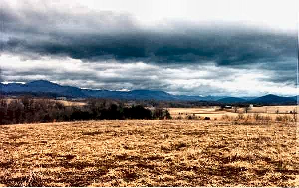
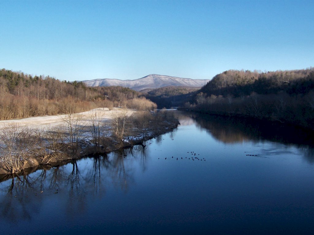
My kith and kin first settled the Appalachian Mountains in the mid-1700's and became farmers and shepherds. Both sides of my family have always had a milk cow or two, chickens for both eggs and pot, hogs, sheep, beehives and gardens. In Les Hamrick's book, 
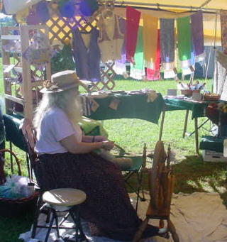
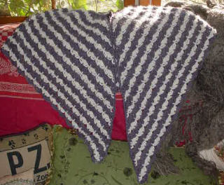
Roots & Wings - The Family Record of Benjamin Hamrick, one of the cover photos is of my female relative, Jane Hamrick. She's in what might be her best dress, seated in her garden spinning a long draw at her Saxony spinning wheel. What's remarkable is her Saxony spinning wheel could be the twin of the Reeves Saxony wheel on which I spin while seated in my sunroom, overlooking the horses, sheep and cattle grazing the Appalachian mountain pastures.

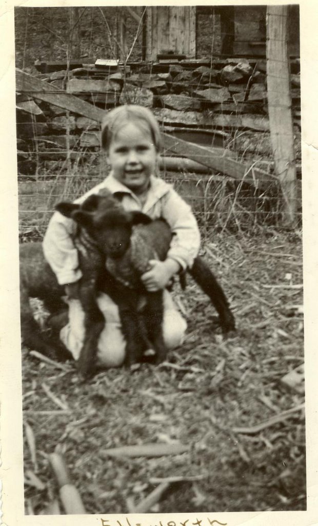
My logo is a 1934 photo of my Daddy, Ellsworth James Bennett. He's kneeling on the ground with his arms encircling twin black lambs. Twin black lambs were a rarity because, at birth, they would usually be killed, stripped of their pelts and then sold to Miss Viola. She would turn those pelts into a French Mouton Fur Coat and then sell the coats to rich New York City women. Daddy was the baby boy and allowed to keep those twin lambs...at least for a time.

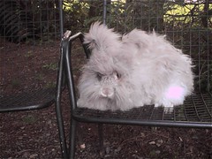
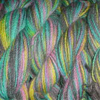
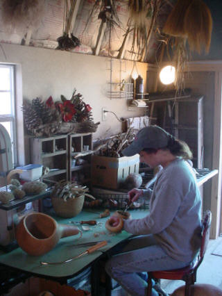
Appalachian Wool Works - Happy Sheep Make Beautiful Wool is my nod of the head to my kith and kin. Of course they would have eaten their sheep as well as used their fleeces and sold both to market but my darlings have no such worries. My sheep are fleece providers only and are well known for their fleece luxuriousness, length, strength and beauty. Like people, when sheep have low stress, the right food and nutrients and drink from crystal clear mountain rivers, they respond by giving their absolute best.

When a woman becomes a first time farmer, rancher or shepherd, she finds out she's, generally, considered to be an anomaly. She has to prove herself in the areas of livestock whereas with crops it's usually a different story. Crops are somehow equated to gardens and gardens to herb gardens and kitchens where, traditionally, women have reigned. Crops in the field and livestock have been a man's domain and he's sometimes a bit reluctant to relinquish his ground...no pun intended.

I've found younger men to be more accepting of me as a farmer and shepherd. Perhaps this is because they see me as a Grandmother figure and they want to lend a helping hand more? I don't know and it really doesn't matter just as long as they keep coming 'round to help out. One young man, James, is very protective and is always calling to ask, "what'cha need help with this week?" He's helped with my sheep by de-worming, feet trimming, shearing and is going to help with fencing and barn repair this spring. A young couple, Danny and Tammy, share both the work and the reward when it's time to cut, kick, bale and put up hay. Ken and Joey have also pitched in when I’ve been in desperate need.

Whoever is here at mealtime puts their feet under my table. It’s the way I was raised and I see no need to change. Millionaires and farm hands have sit down to a table groaning with food and, hopefully, the experience has made us all better. Perhaps that’s one reason why I’ve almost never been without help - people know they will eat and eat well thorough out the day.

The Internet has increased my market from locally (where I struggled to sell anything) to worldwide where I'm known for the quality of my fleeces and my rare breed American Curly horses. The horses number around 4,000 in the world and are known for being hypoallergenic and calm with exceptionally gentle dispositions and temperaments. People from Norway, Japan, Canada and all over the US have visited Thistle Cove Farm because they are interested in a horse that doesn't disturb their allergies.

The Internet has also allowed me to enlarge my personal world as well as my worldview and, I hope, has made me a better person. It has allowed me to sell fiber, goods and horses all over the world and has given me many friendships and has taken me to places I never dreamed of visiting. It’s helped many of my dreams come true.

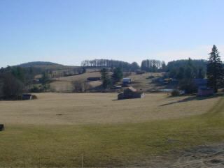
Since I was six years old I've known I wanted to farm and that dream came true when we bought Thistle Cove Farm in the Appalachian Mountains of southwestern Virginia. It took more than four decades but God gave me the desire of my young heart. The lesson of tightly holding onto hope continues to serve me well as farmer and shepherd.

Monday, February 20, 2006

Greenberry House

Greenberry House at Chinquapin Festival
Greenberry House at Chinquapin Festival,
Meadows of Dan, Virginia


The story of Greenberry House, my little business, begins with my great-grandmother's spinning wheel. It sat in a corner of my grandparents' house and survived a couple of generations of playful children who had no real idea of its use or real meaning. I shudder to think these days how often we played with it, turning the wheel by hand at speeds it was never meant to attain. Somehow it survived intact, and as we grew up it stood quiet, treasured by my grandfather because it had belonged to his mother. Eventually it wound up in the attic, and I grew up and went away, forgetting it.

Even though the spinning wheel was forgotten, I was always involved with some sort of craft. As a child I was surrounded by talented people that created beautiful work. My mother's mother was a talented seamstress and quilter, while her father was a woodworker that made beautiful musical instruments. My father's mother was an artist, and so was his sister. Many cousins possessed creative talents as well. I grew up thinking that creating was a natural part of life. Many of the family items in the homes around me were hand made, with purpose, skill and beauty. Quilts, tables, beds, chairs, rugs, tools and other necessities were crafted to last by necessity and with beauty out of the pleasure of creation.

I spent a few years wandering the East Coast, but the call of home was always there, and soon I traveled back to the Blue Ridge Mountains where I was raised, determined to stay and make a place for myself, and a living. While I was away I learned to spin on a drop spindle, with the dog hair I harvested from a cheerful Samoyed dog that was my constant companion during long Maine winters. When I came home I started working at Poor Farmer's Market, a unique country store in Meadows of Dan. I became the gift buyer for the shop and thoroughly enjoyed the work, which was creative and demanding. I put aside my spindle for a time, concentrating on the shop and enjoying the success of a small country store that has grown to be a tourist attraction.

Greenberry House and Iris Garden
Homeplace, Meadows of Dan, Virginia

I moved into my Grandfather Shelor's house in Meadows of Dan in 1994, and in 1999 my mother gave me my great-grandmother's spinning wheel. I learned to spin, teaching myself with some wool I found at a farm in West Virginia. Great-grandma Loucinda's wheel was a little fussy; age had taken a toll but with care and coaxing I could make yarn and I was hooked. I fell in love with angora wool when I tried it on my spindle and soon I had three wonderful German Angora rabbits to start my rabbitry.

GH502
Greenberry House Bunny

The name "Greenberry House" was suggested by a cousin for my rabbitry. Greenberry Steadham was a great-grandfather on my father's side. At first I only planned to keep a few rabbits for myself, but first the bunnies sold well and then the fiber. Right after I bought the angoras I started looking after my grandfather Shelor full-time, working a few hours at night and staying with him during the day and through many nights. My income dropped drastically during this time, and in casting about for ways to make ends meet I found success selling books, bunnies and fiber on my web site. I was able to get away occasionally to deliver bunnies, when my brother's busy family had a few days to spare.

Sweet Faced Autumn Joy
Greenberry's Autumn Joy

By the time my grandfather died after a long decline, the bunnies and books were of necessity supporting most of my needs. I was limited as to what I could do while I stayed with him, but as the business grew I realized I would need to put more time and effort into it. I began working full time with the Internet business, shearing bunnies and designing original pieces that I hand crochet from fibers grown here on the farm, or at nearby farms by other fiber artists. Several times a year I vend at craft shows, and the Mountain Meadow Farm and Craft Market has opened here on the farm, with festivals throughout the summer. I now spin on a modern Reeves wheel, a beautiful hand crafted piece, when I go to shows and for fine fibers. But great-grandma's wheel is still operating well, especially if I want to spin a bulkier yarn that really looks handspun. I also have an antique walking wheel and use some other antique tools to create my hand spun yarns.

Rainbow Shadow
Hand Painted Merino/Angora Yarn

The next step for my business is opening a shop here next to the Parkway, with books, crafts and collectibles as part of my stock. I plan to move my studio from my house into the shop building, where visitors can see my work. Perhaps a friendly bunny will live there as well. My brother, who owns the family farm now, and his wife have plans for a craft shop, a corn maze and other projects here that will benefit the community and my little venture as well. I hope to have my shop open by May 1, 2006.

Winter Shadows
Hand Dyed Alpaca and Natural Angora
Hand Crocheted Cape

The traditional ways of making a living in Meadows of Dan for countless generations have been subsistence farming, shopkeeping and milling, while a few individuals used their talents as carpenters or blacksmiths to support themselves and their families. Just a few generations ago flocks of sheep grazed on the hills in the Busted Rock section of Meadows of Dan, and the wool was used for necessary clothing, rugs, coverlets, and other textiles. My generation and the generation before mine mostly left the farm, turning to factories or leaving the area for higher paying positions in many fields. Those that remain, and have come back, are discovering that factory jobs are few, and that in many cases we have to make our own opportunities for supporting ourselves. For me to be able to make a living here, using the skills of my forefathers, is an opportunity I treasure.

Technorati Tags:

The Southern Appalachian Mountains


Image by, D L Ennis, The James River in the Blue Ridge Mountains of Virginia.

The forests of the Southern Appalachian Mountains are among the oldest and most biologically diverse forests in the world. Sheathing some of the most ancient mountain ranges on earth, the forests of the Southern Appalachian Mountains have served as the heart of evolution for many of North America’s plant and animal species. The geologic and climatic stability of the region over the past 65 million years has afforded sanctuary during extraordinary climate changes, permitting species to weather ice ages and then repopulate in the wake of receding glaciers. The forests of the Southern Appalachian Mountains are currently home to more than 20,000 species of plants and animals.

There are 4.6 million acres of National Forests in the Southern Appalachian Mountains ranging from Virginia to northwest Alabama, offering recreational opportunities, within a day’s drive, to over half of the population of the United States. The wild and magnificent mountainous Monongahela National Forest in West Virginia adds another 900,000 acres of public lands to the network. Southern Appalachian National Forests also include the Thomas Jefferson and George Washington National Forests in Virginia, Pisgah and Nantahala National Forests in North Carolina, the Cherokee National Forest in Tennessee, the Francis Marion and Sumter National Forest in South Carolina, Chattahoochee-Oconee National Forest in Georgia and the Bankhead and Talladega National Forests in Alabama.

The Southern Appalachian National Forests contain 728,487 acres of road-less wilderness which provides refuge to an extraordinary natural legacy: more tree species than in all of Europe; hundreds of native vertebrates, from the mighty black bear to the petite, endangered blue shiner; over half the flowering plants and ferns in North America; abundant migratory songbirds; numerous salamanders; and, one of the greatest intensity of aquatic diversity in the world.

However, as stunning, rare and valuable as the Southern Appalachian National Forests are they still face numerous threats from the Bush Administration’s corporate welfare policies, including increased commercial logging, continued conversion of native forest to pine plantation, oil and gas development, and the negative impacts of illegal motorized vehicle recreation on the forests.


Technorati Tags:

Sunday, February 19, 2006

Bird Watching in the Blue Ridge


Image by, D L Ennis, an immature Cedar Waxwing not long out of the nest.

Bird watching is a fascinating pastime and hobby as well as an entertaining and educational way to spend time with your children. Too many young people are completely out of touch with nature these days, and this needs to change if our wild lands and wildlife are to be preserved for future generations.

In the Blue Ridge Mountains we have an incredible array of birds; some are year round residents, like the Chickadee and the Carolina Wren while others are seasonal residents like the Ruby-throated Hummingbird and Wood Thrush.

There is a wonderful loop trail in the Blue Ridge Highlands that affords an opportunity to see many of our wild birds as well as wildlife and historical sites.

Most of the sites on this loop are in and around Carroll County in the Blue Ridge Highlands. Loop sites span from the New River along the Blue Ridge Parkway to Major J.E.B. Stuart’s Birthplace, and end at two wildlife management areas near the City of Galax. The drive between each site is scenic and can provide extensive wildlife watching opportunities from the road (be careful, drivers!). White-tailed deer are abundant throughout this area, as are woodchuck and eastern chipmunk. Some of these sites, such as Major J.E.B. Stuart’s Birthplace and the Shot Tower Historical State Park, offer a rich historical experience as well. Other sites, such as Devil’s Den Nature Preserve, relay their ancient histories through their fascinating geological characteristics.

Click here for an enlarged, print-quality map (PDF)
NOTE: This file is very large and may take several minutes to download, depending on your connection.

For an interesting site on Bird Watching, I recommend A DC Birding Blog.


Technorati Tags:

Saturday, February 18, 2006

Making a Living in Southwestern Virginia


Family farm, Meadows of Dan

For as long as I can remember, tourism has been a major influence on the area where I grew up. The Blue Ridge Parkway, built along the high ridge in sight of my house, was one of three major construction projects during the 1920s and 1930s that opened a once isolated region to the world. Men came in with the builders, married local girls, and some stayed, while some moved on with their new families. They left behind a community that was changed. With incomes affected by chestnut blight and with an easier way to travel, people began to find other ways of making a living that took them off the small family farm. Some people traveled to the textile mills, while others ventured into the coal fields. The Depression made little difference to the small communities that depended on subsistence farming, but World War II drew even more farm boys away from the mountains.

While natives were leaving the area, tourism began to build on the Blue Ridge Parkway. Travelers passed through, attracted particularly by Mabry's Mill, a unique attraction just a mile from Meadows of Dan. For many years tourists were not a part of the local economy. Eventually as land became available from fading family farms, visitors bought property and built vacation homes in the hills that they had been admiring from the Parkway. A few local entrepreneurs noticed the flow of money that was cruising past, and set up shop at the crossroads to serve the tourists and support themselves. A once sleepy village is now a booming tourist center, especially in the beautiful months of fall.

The modern traveler wants more than pretty scenery. She's looking for an experience and the communities along the Parkway that offer unique shops, music and other entertainment are making a success of tourism. But the shops can only do so much. With family farms in trouble and making a living growing more and more difficult in Southwestern Virginia, a changing landscape may drive the tourists away. Urban sprawl is affecting tourism in more traditional historic areas. While Southwestern Virginia isn't affected to those extents, the loss of the family farm as well as the loss of the local people will leave very little for tourists to enjoy.

Mountain Meadow Crafts Studio
Sue Shelor, Gourd Artist, Mountain Meadow Crafts

There are no easy answers to the problems facing any economy with limited resources. But tourism has become a way for this little community to survive. New inititives like Round the Mountain, an artisan's guild, and The Crooked Road, a traditional music trail, are beginning to offer means to promote artisans and musicians so that they can make a living doing what they love, and benefit their communities with tourist dollars. It's an exciting time for a community that was once made up of farmers, millers and shopkeepers. Traditional arts and farming are once again becoming a possible means of making a living in Meadows of Dan.

Technorati Tags:

Friday, February 17, 2006

Congress May Expand Trail of Tears


Painting by Robert Lindneux (Woolaroc Museum)

The Trail of Tears National Historic Trail commemorates the removal of the Cherokee and the paths that 17 Cherokee detachments followed westward. Today the trail encompasses about 2,200 miles of land and water routes, and traverses portions of nine states.


The National Park Service Thursday endorsed a proposed study of adding perhaps 2,000 miles of land and water routes to the current Trail of Tears National Historic Trail through nine states.

The agency already works to preserve 2,200 miles of federally designated trails to educate the country about the tragic relocation of 16,000 Cherokee Indians from homes mostly in Tennessee, North Carolina and Georgia. They were forced in the winter of 1838-39 to march about 800 miles to newly designated Indian Territory in what became Oklahoma, and more than 4,000 reportedly died.

"The Department (of the Interior) recognizes the importance of telling the complete story of the Trail of Tears," John Parsons, associate regional director of the Park Service, told the Senate Subcommittee on National Parks.

You can read the rest of the story here.


The Legend of the Cherokee Rose

No better symbol exists of the pain and suffering of the Trail Where They Cried than the Cherokee Rose. The mothers of the Cherokee grieved so much that the chiefs prayed for a sign to lift the mother's spirits and give them strength to care for their children. From that day forward, a beautiful new flower, a rose, grew wherever a mother's tear fell to the ground. The rose is white, for the mother's tears. It has a gold center, for the gold taken from the Cherokee lands, and seven leaves on each stem that represent the seven Cherokee clans that made the journey. To this day, the Cherokee Rose prospers along the route of the "Trail of Tears".

"I would sooner be honestly damned than hypocritically immortalized"
--Davy Crockett

His political career destroyed because he supported the Cherokee, he left Washington D. C. and headed west to Texas.


Technorati Tags:

Out of the Blue Zone

Out of the Blue Zone is a new feature on the Blue Ridge Gazette. We will take a look at things going on in other regions of our natural world. Today, Queensland, Australian and Virginia Beach, Virginia, USA.

Fooling with Mother Nature

What happens when we fool with Mother Nature can be devastating to our environment; and usually is! First, Bufo marinus (cane toad) in Queensland, Australia. Then, the nutria, (Myocastor coypus) and the gaffe in the Back Bay National Wildlife Refuge in Virginia Beach, Virginia.


A poisonous cane toad sits on a keeper's hand at the Taronga Zoo in Sydney. The cane toad (Bufo marinus).

”Darwin's nightmare: Toxic toad evolves to secure supremacy”

PARIS (AFP) - He's fat, ugly and poisonous -- and he's mutating. He's the cane toad (Bufo marinus), a species which was introduced into the Australian state of Queensland 70 years ago to tackle insect pests in canefields and has since become an ecological catastrophe.

Weighing in at to up two kilos (4.4 pounds), the unwanted anuran has extended its range to more than a million square kilometers (386,000 square miles) in tropical and sub-tropical Australia, crushing native species in its relentless advance.

A team of University of Sydney toad watchers positioned themselves on the front line of the invasion, 60 kilometers (35 miles) east of the city of Darwin, and for 10 months caught toads, some of which they radiotagged and let loose again.

They were astonished to find that the creatures can hop up to 1.8 kms (1.1 miles) a night during wet weather, a record for any frog or toad.

To read the rest of this story click here.


Back Bay National Wildlife Refuge

I grew up primarily in Virginia Beach, Virginia and spent a great amount of time at the Back Bay National Wildlife Refuge, fishing, hunting and trapping.

Back Bay Refuge contains over 8,000 acres, situated on and around a thin strip of coastline typical of barrier islands found along the Atlantic and Gulf coasts. Habitats include beach, dunes, woodland, farm fields, and marsh. The majority of refuge marshlands are on islands contained within the waters of Back Bay.

The varied habitats at Back Bay Refuge provide food and cover for mammals such as river otters, white-tailed deer, mink, opossums, raccoons, and the red fox Nutria, introduced to the United States from South America in the early 1900's are common in refuge marshlands. Other non-native species include feral horses and pigs. These animals compete with native species for food and cover, and are responsible for negative impacts to the managed environment. Nutria damage dikes through burrowing activity; pigs uproot valuable marsh vegetation; and horses trample plants and litter the area with their droppings.

In the 1960’s a bounty was put on the nutria, (Myocastor coypus), is a large semi-aquatic rodent. They were brought in from South America for two reasons, the fur trade and in hopes of controlling the Muskrat, which was doing a lot of damage to marshlands through their burrowing. Nutria nest and were thought to nest above ground and not to be burrowing. Instead they used the tunnels that the Muskrats created only, because of the nutria’s size, the tunnels grew larger; result, even more damage. (Nutria weigh an average of 12.0 pounds (5.4 kg).

In addition to their size, adding to the damage problems, nutria are prolific breeders.

They breed year round and are extremely prolific. Males reach sexual maturity between 4 and 9 months, whereas, females reach sexual maturity between 3 and 9 months. Sexual maturity may vary with habitat quality. With a gestation period of only 130 days, in one year, an adult nutria can produce two litters and be pregnant for a third. The number of young in a litter ranges from 1-13 with an average of 4.5 young. Females can breed within a day of having a litter. Litter size can vary with age of female, habitat quality and time of year. The young nutria at birth are fully furred and the eyes are open. Newborn nutria feed on vegetation within hours and will nurse for 7-8 weeks.

Also, nutria predominately feed on the base of plant stems and dig for roots and rhizomes in the winter. They often construct circular platforms of compacted, coarse emergent vegetation, which they use for feeding, birthing, resting and grooming. Nutria may also construct burrows in levees, dikes and embankments.

Will we ever learn to leave Mother Nature alone?

Note: I no longer hunt or trap, and rarely go fishing; usually for native trout.

Technorati Tags:

Thursday, February 16, 2006

New Battle at Gettysburg

There is a new battle being fought at Gettysburg, a battle against vandals. What makes people do these things? It is repugnant and disgraceful!


Vandals damaged monuments and removed parts of sculpture at the Gettysburg National Military Park in the third such incident in a little over a year.

Two bronze sculptures honoring New York and Pennsylvania soldiers were dragged from their places, and a sword is missing from a sculpture honoring Massachusetts infantry, park spokeswoman Katie Lawhon said Thursday.

The bronze head of an artilleryman figure was removed at the New York monument, she said. The vandalism occurred late Wednesday or early Thursday.

You can read the rest of the story here.


Gettysburg National Military Park:

Gettysburg National Military Park is located 50 miles northwest of Baltimore, the small town of Gettysburg, Pennsylvania was the site of the largest battle ever waged during the American Civil War. Fought in the first three days of July 1863, the Battle of Gettysburg resulted in a hallmark victory for the Union "Army of the Potomac" and successfully ended the second invasion of the North by General Robert E. Lee's "Army of Northern Virginia". Historians have referred to the battle as a major turning point in the war, the "High Water Mark of the Confederacy". It was also the bloodiest single battle of the war, resulting in over 51,000 soldiers killed, wounded, captured or missing.


Image: Enlisted Men's Tent

These items in the tent were typically used by two enlisted Union soldiers in a field camp. The enlisted men's tent depicts food and cooking utensils, cards, pipe, rubber blanket, and other items.

The rubber blanket spread on the ground was a prized piece of equipment for G.F. Wiltshire, 4th New Jersey Volunteer Infantry. He used it as a waterproof ground cloth or poncho.
The hook lying on the large cooking pot is a ramrod bent to serve as a pot hook. It was found in a Civil War fire pit near Harpers Ferry, West Virginia.

Near the front of the tent is a package of hardtack in its original heavy waxpaper wrapping.

Technorati Tags:

Backyard Bird Count for 2006

I was just viviting a wonderful birding blog, "A DC Birding Blog" and John over there has a great article called "The Great Backyard Bird Count for 2006." Check it out and while you are there look around, if you are into birds you will love this blog!

Here is an excerpt from "The Great Backyard Bird Count for 2006":

The Great Backyard Bird Count for 2006 is coming up this weekend, February 17-20. The GBBC is one of several "citizen science" projects that are coordinated by the National Audubon Society and the Cornell Lab of Ornithology. Like the Christmas Bird Count and mid-winter counts run by local birding clubs, the GBBC aims to establish bird population and distribution. What sets the GBBC apart is that this count provides a nationwide picture of bird populations over a single weekend, rather than the two-week period of the CBCs or the local picture of the mid-winter counts. The late February date places the GBBC at a time when most birds are on their wintering ground - after fall migration is done and before spring migration is taking off.


Technorati Tags:

Wednesday, February 15, 2006

Federal Threatened and (or) State Endangered Turtles of Virginia’ Blue Ridge Mountains


We have two turtles (Order: Testudines) in The Blue Ridge Mountains of Virginia that are Federal Threatened and (or) State Endangered. One is the bog turtle (Clemmys muhlenbergii) which lives in bogs, swamps and wet meadows in the southern Blue Ridge Mountains; primarily the Blue Ridge Plateau. It is Federal Threatened & State Endangered. The other Blue Ridge endangered turtle is the wood turtle (Clemmys insculpta) and is found in the northern portion of the state and is listed as State Threatened.

The bog turtle, Clemmys muhlenbergii, is a small turtle that prefers high elevation, mountain wetlands. With a maximum carapace length of approximately four inches, this little turtle was once thought to be common. It is extremely habitat-specific, requiring an open bog with freshwater seepage. Speculation as to how these bogs were once maintained is that bison, elk, and beaver played a major role grazing them clear. The eradication of many of these large mammals and the encroachment of man combined to spell disaster for this diminutive species.

Presently, the bog turtle is being assaulted on two fronts. First, its size and temperament make it attractive to the pet trade and collection, both private and commercial, has reduced the wild population. Secondly, and perhaps most devastating, is habitat destruction. Many wetland sites have been drained for agriculture, business, and roadways. Because of these factors, the bog turtle was placed on the federal endangered species list. The northern population's status is threatened, and receives full protection under the U.S. Endangered Species Act. The southern population is protected due to similarity of appearance only, pending the results of ongoing survey work.

This is a small freshwater turtle that has a maximum carapace length of 4.5 inches. The carapace is roughened with growth rings that are dark brown to black, sometimes with irregular radiations or markings, and has a smooth posterior rim. This species is not sexually mature until 6 years of age. It breeds from late April to early June, in shallow water and on land, and eggs hatch in the Fall. There may be two clutches/year and it takes from 50-59 days for the eggs to hatch. The eggs are laid in shallow nests in grass tussocks, moss, or soft soils. This species is active only during April, May, June and September and aestivates during high temperatures. It is usually seen only during the early spring and during the nesting season because the dead and matted grasses and sedges form a dense ground cover during late spring and summer. During the winter this turtle hibernates below the frost depth in holes, muskrat burrows, in sedge clumps, or in the mud of waterways. The mean home range is 3.2 acres. Bog turtles bask during midday on grass mats or in shallow rivulets.

This species is found in Virginia only in the southern Blue Ridge Plateau above 610 meters elevation. It inhabits sphagnum bogs or wet sedge meadows in or near slow moving streams with a muddy bottom. The highest populations occur in the shrub stage of forest succession. Alder, skunk cabbage, and sedges are common plant associations.

The bog turtle eats berries, insects and dead animals. Known prey includes a variety of insects, earthworms, slugs, snails, millipedes, crayfish, tadpoles, duckweed, seeds of pondweed (Potamogeton) and sedges (Carex), blackberries and strawberries.


The medium sized wood turtle (Clemmys insculpta) is found in the northern portion of the state and is listed as threatened. Whereas many people think of turtles as simple, the wood turtle exhibits an interesting and complex behavior know as "worm stomping." Wood turtles in other states have been observed to stomp their legs on the ground for at least 15 minutes, waiting for earthworms. It is thought that the stomping resembles falling rain vibrations, and the earthworms come to the surface as a result.

This is a medium-sized turtle, up to 9 inches in length, with a keeled, sculptured carapace. The broad, low carapace is rough, and each large scute supports an irregular pyramid formed by a series of concentric growth ridges. The skin is dark brown to black, often with some orange or red pigment on the forelegs and neck. The tail is rather long. Wood turtles lack the bright orange patch on the side of the head found in the bog turtle. Hatchling wood turtles are gray to brown and lack red or orange pigment on the head and legs. Known hatchling emergence dates in Virginia are from June to August. Clutches of 7-14 eggs are most common. Wood turtles emit a courting whistle sounding like a tea kettle. This species is usually found roaming alone except when mating. It is a very good climber. It has a rather restricted home range and some individuals turn up year after year in the same place. This species is generally terrestrial during the warm part of the year, and aquatic during cool spells and hibernation. It hibernates in deep pools or under the mud or sand bottom of its waterway, or just sits on the bottom or crawls up under the overhanging roots of trees along the bank. Virginia specimens observed in the winter were under submerged logs, in beaver lodges, and in muskrat burrows. Although highly terrestrial, wood turtles must remain in moist habitats as they experience a greater evaporative water loss than the more terrestrial box turtles. Populations have declined due to degradation of aquatic habitats, loss of wetlands, fragmentation of habitats, urbanization, being killed by vehicular traffic, and from the collection of adults and juveniles for the pet trade.

In Virginia, this species has a restricted range extending from Arlington and northern Fairfax counties westward through Loudoun and Clarke counties to Frederick, Warren and Shenandoah counties. It has recently been found in northwestern Rockingham County. It inhabits a variety of habitats, such as forested floodplains, fields, wet meadows, and farmland, as long as there is a creek or stream nearby.

The wood turtle eats both animal and plant food items, including berries, herbs, algae, moss, fungi, grass, insects, mollusks, earthworms, dead fish, tadpoles, newborn mice and other turtles' eggs. It will forage on the ground, in the water, in herbaceous vegetation, and on logs.


Please, if you come across either of these turtles, let them live and leave them to go on their way!


Technorati Tags:

Trail of the Trees; and Bird Watching


Winter is a great time for studying tree identification. The mountains look steel-gray from a distance. The forest, up close, is a study in muted earth tones. There’s smooth gray bark, scaly, nearly black bark, fissured gray bark and papery yellow bark to name a few. There are terminal buds, auxiliary buds and lateral buds. Twigs may be hairy (pubescent) or smooth (glabrous). By learning these characters and characteristics, you can turn a winter forest of cold gray and brown timbers into a living forest of black cherry, red maple, basswood, mockernut hickory, Southern red oak, Northern red oak, etc.
The Trail of the Trees can be accessed from the James River Visitor’s Center on the Blue Ridge Parkway at milepost 63.8. Elevation: 731 ft.


Image right: Canada Geese on the James River. Click image to enlarge.

This short 0.5-mile loop trail offers hikers river bottomland habitats, upland hardwood-hemlock forests, and several overlooks with views of the James River. This short self-guided tour can be productive for birders during spring and fall migration. On the river, one may find waterfowl such as blue-winged teal in the spring. Fall migration is more likely to bring fly-over migrants, such as broad-winged hawk, osprey, and common nighthawk. Nesting avian species include scarlet tanager, wood thrush, Baltimore oriole, and warbling vireo. Cliff swallows build their nests beneath the bridge, but patrol the river along with barn and tree swallows. In the winter, the river holds bufflehead, hooded merganser, and American black duck. However, during inclement weather, the Blue Ridge Parkway may be closed, so you may want to call ahead.

Images by D L Ennis

Technorati Tags:

A Call for Writers

If you are interested in eenvironmental issues, nature, wildlife, wildflowers, camping, hiking, rockclimbing, great places to visit in the mountains of the Blue Ridge, traditional music ( Celtic, Folk, and Blue Grass) or any number of other related items, then why not join me. I would love to expand the Blue Ridge Gazette but I need help!

If you are worried about the time involved in working on this project, don’t. You can post as often or as little as you like.

So, if you are interested in working with me please drop me, D L Ennis, a line at, blueridgegazette@gmail.com.


Technorati Tags:

Tuesday, February 14, 2006

Wine and Dine at Château Morrisette


Nestled in the Blue Ridge Mountains and open year round, Château Morrisette welcomes visitors to tour their facilities, experience their wines and savor their American cuisine while enjoying such events as Black Dog & Our Dog Blues Concerts all in an elegant old world atmosphere. A comfortable drive from the Piedmont Triad, Charlotte, Roanoke and Martinsville, Château Morrisette is both a relaxing and exciting experience for anyone who enjoys fine wine, good food and natural surroundings.

Château Morrisette is located in a spectacular mountain setting in Floyd County off the scenic Blue Ridge Parkway between mileposts 171 and 172. The winery and gift shop are open seven days, Monday-Thursday 10:00 a.m.-5:00 p.m., Friday-Saturday 10:00 a.m.-6:00 p.m. and Sunday 11:00 a.m.-5:00 p.m.

The restaurant at Château Morrisette serves lunch Wednesday-Saturday 11:00 a.m.-2:00 p.m., Sunday lunch/brunch from 11:00 a.m.-3:00 p.m. and dinner Friday-Saturday 6:00-9:00 p.m.
Make plans to visit their restaurant, gift shop and gardens, the winery for a tour and wine tasting, or stop by for one of their special events.

I have only tried two of their wines and I love them both! One of them is “Our Dog Blue:”

A popular white wine, Our Dog Blue is a semi-sweet blend of Riesling with a small amount of Vidal. Aromas of mint, honeydew and apricot highlight the soft finish of this soothing wine. Serve chilled with fruits and cheeses or with spicy Chinese food.

The other Château Morrisette wine I have tried and love is “Sweet Mountain Laurel:”

A unique and refreshingly sweet dessert style wine made from Native American grape varieties. A firm acidity balances the natural sugars, producing a crisp finish with aromas of freshly picked grapes. Pour over fresh berries and sponge cake or blend with vanilla ice cream and fruit for a creamy dessert smoothie.

For more information visit the Château Morrisette website.


Technorati Tags:

Monday, February 13, 2006

Abbreviated Blue Ridge Geology

I received an email today from a young reader asking about the basic geology of this region so I thought I would post this here. As a rule, something like this might be found on another one of my pages, Blue Ridge Reflections. I may go farther in-depth on this subject later and repost it to BRR.


The Blue Ridge is composed of complexly folded and faulted igneous (granitic) and metamorphic rocks. These rocks date to the Precambrian and Paleozoic and represent parts of the basement rock of the North American continent. (See geologic cross-section below.)


When Africa and North America converged during the Paleozoic, these rocks were thrust upward and many miles westward over younger rock materials. Today the general surface of the Blue Ridge lies at about 3000 feet above sea level, with many peaks reaching another 1000 to 2000 feet higher. Elevations increase toward the southwest and culminate in Virginia's two highest peaks, Mt Rogers (5,729') and Whitetop Mt. (5,520'), located near the state's southern border. The Blue Ridge physiographic province is subdivided at Roanoke Gap into two distinct subregions.

Physiographic Subregions of the Blue Ridge

Image above: Blue Ridge geologic cross-section

The area in black is the Blue Ridge Plateau

Blue Ridge Mountains
North of Roanoke Gap, the Blue Ridge occurs as a narrow chain of mountain peaks. Shenandoah National Park lies atop the northern part of the Blue Ridge Mountains. When first set aside in the 1930s, the parkland was deforested and deeply eroded; much of its natural vegetation and wildlife has since been restored to make Shenandoah one of Virginia's main tourist attractions.

Blue Ridge Plateau
South of Roanoke Gap, the Blue Ridge widens into a high plateau. Scattered monadnocks -- A mountain or rocky mass that has resisted erosion and stands isolated in an essentially level area. Also called inselberg.--rise above the general surface level. Mt. Rogers and Whitetop Mt. are on the Blue Ridge Plateau, but geologically, are not part of it. They are composed of volcanic rocks, the origins of which have yet to be fully understood.

Technorati Tags:

Sunday, February 12, 2006

Bush Administration Proposes Selling National Forest Land


Image: by D L Ennis, Autumn in the Blue Ridge.

Even though the proposal is to sell "isolated parcels," it could be a devastating move in that it may open the door to the loss of larger and more important segments of our National Forest through future sales. This is the biggest worry I have about this issue. I mean, once they start selling off public land to use the money elsewhere where will it end. The next thing you know, it turns into another social security debacle! I would be interested in knowing what you think.


The Bush administration will unveil a proposal Friday to sell up to 200,000 acres of national forest land in "isolated parcels" ranging from a quarter of an acre to 200 acres, much of it in California.

The sale is part of a National Forest Service plan to raise $800 million over the next five years to pay for rural schools in 41 states, offsetting shrinking revenues from sale of timber from national forests. The Bureau of Land Management also plans to sell federal lands to raise an estimated $182 million over five years.

Environmentalists charge that the short-term gain would be more than offset by the loss of public land. Congress would have to approve the land sales, but it has rejected similar recent proposals.

"I am outraged, and I don't think the public is going to stand for it for one minute," said Wilderness Society policy analyst Mike Anderson. "It's a scheme to raise money at the expense of the national forests, the wildlife, recreation and all the other values that Americans hold dear. It's the ultimate threat to the national forest."

Jerry Taylor of the Cato Institute, a libertarian think tank, said the proposed land sales make sense.

"Private property will end up in the possession of those who value it the most," Taylor said. "That is an iron law of economics."

Details about what plots of land would be put up for sale are expected to be revealed at a noon press conference by Undersecretary of Agriculture Mark Rey, a former timber industry lobbyist. The Forest Service owns 193 million acres of land and plans to sell about 175,000 to 200,000 acres, according to Forest Service spokeswoman Heidi Valetkevitch.

"They could be theoretically from every national forest," Valetkevitch said. "California has a lot on the list, I understand."

The lands in question aren't environmentally sensitive wilderness or protected scenic areas, Valetkevitch said. "It could be something that's in a neighborhood that people don't even know is forest land," she said.

Sen. Dianne Feinstein, D-Calif., attacked the plan as "crazy," saying: "Here the administration wants to pass more tax cuts for the rich, and to pay the bill, they want to sell off public land _ our nation's natural heritage."

The Forest Service owns 20 percent of California, including much of the Sierra Nevada, Lake Tahoe, Big Sur and dense forests along the Oregon border. The Bureau of Land Management owns 15 percent of the Golden State.

Rural schools get 25 percent of federal forest timber sale proceeds, but those revenues have fallen, so the idea is to sell forest land to make up for that, Valetkevitch said.

Anderson of the Wilderness Society argued that money for rural schools could come from many sources and that the land sales are being proposed "so the budget deficit doesn't get worse." He noted that if forests are sold, future federal timber sales likely would yield even less money for rural schools.

The president's new fiscal 2007 federal budget calls for the bureau to raise $1 million in 2007 land sales, $28 million in 2008, $40 million in 2009, $42 million in 2010 and $71 million in 2011.
Dave Alberswerth, a Wilderness Society senior policy adviser, said that would be "way more than they have been selling in recent years." From 2000 to 2004, the bureau sold 13,160 acres for an average price of $320 an acre, he said. At that rate, the government would have to sell more than half a million acres to garner $182 million.

For more information: http://www.krtdirect.com/


Technorati Tags:

Saturday, February 11, 2006

John Muir: Father of the Ecology Movement


In God's wildness lies the hope of the world - the great fresh unblighted, unredeemed wilderness. The galling harness of civilization drops off, and wounds heal ere we are aware. –John Muir (1838-1914)

In1892, John Muir wrote to the editor of Century Magazine, "Let us do something to make the mountains glad." So they founded the Sierra Club, the first major organization in the world dedicated to using and "preserving" wild nature. It is from this act that the modern Ecology Movement was born.

Throughout his life, Muir was concerned with the protection of nature both for the spiritual advancement of humans and, as he said so often, for Nature itself. This dual vision still informs the ecology movement and inspires millions to reform their thought and minds, to orient themselves as part of nature. Though the arguments in favor of ecological thinking are often couched in scientific terms, the basic impetus remains as Muir stated it: "When we try to pick out anything by itself, we find it hitched to everything in the universe."

John Muir- A Brief Biography.


Technorati Tags:

Help Your National Parks


Image: Shenandoah National Park

The national parks belong to everyone and there are many ways you can help your parks. You can leave no trace when you visit the parks. You can also become more actively involved in the stewardship of these national treasures.

For example, you can:

Volunteer in a National Park... Help preserve and protect America's natural and cultural heritage for the enjoyment of this and future generations. At the same time enjoy volunteering in a park performing rewarding projects. Volunteer opportunities abound for groups and organizations such as Scouts, Student Conservation Association crews, the local community. They also abound for individuals.

Work in a National Park... The opportunity to work in the National Park Service can be the chance of a lifetime. There are over 380 national parks in the United States. Each can be a place in which to gain experience and help develop a career. A career in the NPS may lead you through some of our nation's crown jewels and to discover some of its less-known natural wonders. It may bring you to a new perspective on our heritage, an enhanced respect for our people and their history, as well as an appreciation of the complexities of managing our natural resources. It is challenging and rewarding. We invite you to apply.

Internship in a National Park... We invite you to internship in some of the most beautiful areas of the country. Many parks and central offices offer opportunities for interesting and educational Internships.

For more information visit the National Park Service Website.

Technorati Tags:

Friday, February 10, 2006

Through Today’s Children a Better World Can Evolve


Image: Catelyn Penrod and Sammy May visit with ‘Babe.’ The students are trying to raise money to buy goats for the Zulu people of South Africa.

This is way out of our region, White Mountains of Arizona, but I had to report it. This is the kind of thing that most of our youngsters are not being exposed to enough. If we are ever to get along in this world we need to understand and be willing to help other cultures. The way to this understanding is through our children.

I encourage all educators to get the children they teach involved in this kind of program. Through today’s children a better world can evolve, but they need our help!


'Heroes' to buy goats for South Africans

PINETOP-LAKESIDE — The “Raskimuk Heroes” want to make a difference in South Africa. The students in Laurie Rask and Donna Maksimuk’s fifth grade class at Blue Ridge Middle School are raising money to buy goats for South African families.

The goats will be “loaned” to families, supplying them with much-needed healthy milk for babies and children. Because of the AIDS epidemic in Africa, mothers often can’t breast-feed their own children. In such cases, goat’s milk is a lifesaver.

The families can also earn income by producing and selling cheese and milk.

Read the rest of the story here at "The White Mountain Independent's Online."


Technorati Tags:

Tonight: Celtic Music Jam at Givens


Come on out to Givens Books tonight for the Celtic Music Jam!

Givens Books and Little Dickens, Lynchburg's largest and oldest independent bookstore and finest toy and teacher supply store. Established in 1976, it continues to be run by the Givens family.

Both stores merged in 1999 and built a 16,000 square foot facility, which now houses Virginia's largest collection of new and used books, toys and educational supplies under one roof.

· FREE FRIDAY CONCERT - Every 1st Friday of the month from 7:30 - 9:30 PM. Enjoy the delicious food at the Drowsy Poet, browse through the books while you listen or just have a seat and enjoy the show!
· CELTIC MUSIC JAM - Every 2nd Friday from 7 - 9 PM.

Both events are free and open to the public!

Technorati Tags:

Thursday, February 09, 2006

Mill Mountain Zoo Gets New Director: Seeking Accreditation


The Mill Mountain Zoo in Roanoke, Virginia has hired a new Director, Sean Greene, whose initial priority is to gain accreditation from the American Zoo Association (AZA).

This from the Roanoke Times:


When he comes to the Roanoke Valley, Greene said a top priority will be to get the zoo accredited by the American Zoo and Aquarium Association. The AZA gave Mill Mountain a year's extension after former director Beth Poff resigned last year to take a job as director of the Jackson Zoo in Mississippi.

"The Mill Mountain Zoo is only going to be as successful as the community that embraces it," Greene said. "Right now our most critical thing is our AZA accreditation. It's extremely important. That's going to be my top priority."

Sara Brooks, vice president of the Blue Ridge Zoological Society, said, "Sean was really the best for us and our community and our zoo. He's just very outgoing, dynamic. He arrived for his interview incredibly well prepared. He's already taking charge of our AZA accreditation. He was very well thought of by the AZA."


You can read the rest of the story here.


One of my favorite animals at Mill Mountain Zoo is the Red Panda; pictured right.

Habitat: Bamboo forest of Nepal, Burma and South Central China
Diet: Bamboo sprouts, grasses, roots, acorns, occasional small animals
Zoo Diet: Bamboo, gorilla biscuits, apples, and bananas

Red Pandas, also known as Lesser Pandas are not as well known as the larger, black and white, Giant Panda although they share similar habitat and habits. At only 10-15 pounds Red Pandas are agile climbers and spend much of the time in treetops. Red Pandas are part of the Species Survival Plan and are bred in captivity to help ensure the future of the species. Mill Mountain Zoo has had several successful births of panda cubs. Zookeepers hold daily training sessions with our Red Pandas in order to make it less stressful for the animals to be weighed and given medication or placed in travel crates.

Prices and Hours at Mill Mountain

Mill Mountain Zoo is open daily, year round, seven days a week. (Closed Dec. 25th)

Hours: 10:00 a.m. to 4:30 p.m. Grounds close at 5:00 p.m.
Admission: $4.75 for adults, $3.50 for children 11 and under, $4.28 for seniors (all plus tax), children two and under are free.

Memberships are available for $15 Individual, $40 Grandparents, $45 Family. If you would like membership information email info@mmzoo.org. AAA, Group and School Discounts are also available. Visa and MasterCard, Discover accepted.

Zoo Choo: Closed for winter will re-open weekends in March.

Handicap Accessibility: We are handicap accessible with paved pathways for your convenience. Handicap parking and drop-off available near front gate.

Picnic facilities are located within the Zoo for your convenience.


Technorati Tags:

Wednesday, February 08, 2006

Peregrine Monitoring Begins


NPS photo, Peregrine Falcon

The National Park Service is again monitoring for Peregrine Falcons at the Endless Wall and Beauty Mountain areas within the New River Gorge National River. The park is asking the public to assist them by using other sites within New River Gorge for climbing, hiking and other outdoor uses starting in mid-February and ending in late-April.

The National Park Service has conducted limited monitoring every year since peregrines were reintroduced to the park in 1987-1990, but no nesting pairs have been found. The NPS believes human activity during the bird’s critical “courtship” period may be one of the key reasons that no nesting activity has been observed in New River Gorge.

Because of the peregrine’s sensitivity to human activities when seeking suitable nesting sites, NPS is asking the public to limit their use of the area located between Diamond Point on Endless Wall and Keeney's Creek drainage for a period of ten weeks - between February 13 and April 29, 2006.

If you plan to hike or climb near the Endless Wall, please consider alternative locations to ensure the effectiveness of this monitoring program. Sites offering similar recreational opportunities are listed below. Additional information can be obtained at the Canyon Rim Visitor Center. If you have specific questions or concerns please call (304) 465-6542 or 465-6531.

The NPS is also asking for the public’s help. If you observe Peregrine Falcons near New River Gorge, or would like to participate in the monitoring program, please call the NPS at 304-465-6542.

Contact Information
Ken Stephens 304 465-6531

About the Park

A rugged, white water river, flowing northward through deep canyons, the New River is among the oldest rivers on the continent. Located in southern West Virginia, New River Gorge National River was established in 1978 to preserve and protect 53 miles of the New River as a free-flowing waterway. This unit of the National Park System encompasses over 70,000 acres of land along the New River between the towns of Hinton and Fayetteville. The park and the surrounding area are rich in cultural and natural history, and contain an abundance of scenic and recreational opportunities.


Technorati Tags:

Hiking Looking Glass Rock


Image: by Wayne Busch- View of Looking Glass Rock from the Blue Ridge Parkway

You may have seen this view of Looking Glass Rock from the Blue Ridge Parkway at Milepost 417, south of Mount Pisgah and near Graveyard Fields. The stone face looks impossible to hike, and you sometimes see professional rock climbers on this impressive peak.

Good news! If you drive around to the other side of Looking Glass Rock in the Brevard area, you will find a very walkable trail to the top to enjoy the great views, looking back toward the Blue Ridge Parkway. The Looking Glass Rock Trail is extremely popular and can be a bit crowded on warm weather weekends. It's perfect for a winter hike. (Be careful of ice on the rock face at the top in cold weather.) It's only about 45 minutes from downtown Asheville.

The Looking Glass Rock Trail climbs about 1,700 feet in just over three miles (6.5 miles roundtrip, allow 4-5 hours). The many switchbacks along the way help make for a long, but only moderately difficult climb. The views from the top are well worth the effort. The trail is well blazed in yellow and easy to follow.

The trail starts off following a stream with some small cascades along the way, before beginning a series of switchbacks up the mountain. Sections of the trail takes you through tunnels of rhododendron and mountain laurel.

After about two miles, the trail reaches a flat rock area, which is used as a helicopter pad by the local rescue squad for injured rock climbers. This is a good resting spot. A spur trail heads off to the left past the helipad, which leads to some nice views from Lower Looking Glass Cliffs.

At the helipad, the main trail heads off to the right (follow yellow blazes) and continues its climb to the summit. There are a couple of nice campsites, but you can't see much from the actual summit. The trail continues past the summit and after a short descent you will arrive at Upper Looking Glass Cliffs where you will be treated to some spectacular views. Do not get too close to the edge! It is very easy to slip, and a fall from here would most certainly be fatal.


Image below: The start of the 3.2 mile climb to the top

Directions from Downtown Asheville (about 36 miles):

Take I-240 West / I-26 East. Continue on I-26 East to Exit 40 for Highway 280 (and the Asheville Airport). Take a right onto Highway 280 West and go 16 miles toward Brevard. As you enter the Brevard area, you will see a big shopping center on the right (with Wal-Mart). Just past the center, turn right onto US Highway 276 North to enter the Pisgah National Forest. Go 5.3 miles and turn left at the sign for Pisgah Center for Wildlife Education and the State Fish Hatchery. Go 4/10 of a mile and look for the parking area on the right for Looking Glass Rock Trail Head. For more information about the many hiking trails in Pisgah National Forest, stop at their Visitors Center on US 276 on the way to the Trail Head.


Technorati Tags:

Hampshire County Arts Council, Presents


Cabin Fever in Concert

This Celtic music ensemble consists of Jo and her husband, Wayne, who joins Jo on shuttle pipes and vocals. This unusual combination of harp, pipes, and vocals makes for a varied and unique Celtic program.

Cabin Fever Concert Port Righ The Celtic duo, of Jo Morrison on harp and Wayne Morrison on the shuttle pipe is an instrumental pairing rarely seen in Celtic music. Specializing in traditional Scottish music, from lively marches to wistful, expressive airs, they broaden their repertoire with traditional Irish music, vocal pieces and original works.

Saturday, February 18, 7:30 PM
(snow date: Friday, February 24)
Admission $7 (HCAC members $5) 16 & under free.
The Bottling Works
Main Street
Romney, West Virginia

Visit the Hampshire County Arts Council events calendar here.

Visit Jo Morrison' web site.


Technorati Tags:

Tuesday, February 07, 2006

Visit Harpers Ferry National Historical Park


Click on the map for a larger view.

Harpers Ferry National Historical Park is located at the confluence of the Potomac and Shenandoah rivers in the states of West Virginia, Virginia, and Maryland. George Washington, Thomas Jefferson, Meriwether Lewis, John Brown, "Stonewall" Jackson, and Frederick Douglass are just a few of the prominent individuals who left their mark on this place.

The story of Harpers Ferry is more than one event, one date, or one individual. It involves a diverse number of people and events that influenced the course of our nation's history. Harpers Ferry witnessed the first successful application of interchangeable manufacture, the arrival of the first successful American railroad, John Brown's attack on slavery, the largest surrender of Federal troops during the Civil War, and the education of former slaves in one of the earliest integrated schools in the United States.

Start your visit at the Visitor Center, located on Cavalier Heights about one mile west of the Shenandoah River bridge just off U.S. Route 340. The Visitor Center is open every day except Thanksgiving, Christmas, and New Year's Day. Hours of operation are from 8:00 a.m. to 5:00 p.m.

Entrance Fees

Your park entrance fees support park preservation, education, and maintenance. They are valid for three consecutive days, beginning on date of purchase, at Harpers Ferry National Historical Park.

Entrance passes are required in all park areas and fees are payable at Cavalier Heights Entrance Station, Bolivar Heights, Maryland Heights, Harpers Ferry Train Station, and River Access Parking Lot. Credit cards are accepted only at Cavalier Heights.

Vehicle Pass - $6.00 per single, private vehicle (excludes group tours and 7+ passenger vans –group fees

Individual Pass - $4.00 per person arriving on foot, bicycle, or motorcycle (or $5.00 per immediate family).


Technorati Tags:

The Seminole Trail—Connections Made


Image: by D L Ennis, Mother and Daughter dance at a Monacan Powwow in Amherst County, Virginia.

How did the “Seminole Trail" along US Route 29 in Virginia, get its name? Good question and it will likely remain a mystery forever. We know that in 1928, Virginia's General Assembly voted to name route 29 the Seminole Trail. “Ann L. Miller, a Virginia Department of Transportation historian, said the act -- Senate Bill 64 -- gives no clue why they picked that name or who initiated the proposal.”

The Answer Man, as he’s called, of the Washington Post says,


Many early roads followed old Indian trails, so you might expect that to be the case here. There's just one hitch: The Seminoles aren't a Virginia tribe. They never have been. They're mostly connected to Florida, where they were born from the fragments of earlier tribes that had sparred with colonists as well as runaway slaves who were looking for freedom.


He’s right that, “Many early roads followed old Indian trails…” He is also right that, “The Seminoles aren't a Virginia tribe.” However, is has been argued by, Joseph Opala, an anthropologist at James Madison University in Virginia, (who has studied the Seminole since the 1970s) that the Seminoles were a multiethnic tribe from their beginning. This is to say that the Seminoles are a permutation of various tribes as well as runaway slaves.

The Seminole were originally part of the Creek, and they began to migrate from Southern Georgia to Northern Florida in the later half of the eighteenth century. Other tribes that mixed with the Seminole were the Timuquan, Calusan, and Muskhogean. Other tribes in the area were the Choctaw, Chickasaw, Cherokee, Yuchi, Yamassee and Apalachicola and it is likely that members of these tribes also came to be with the Seminole.

Now back to the fact that the Seminole were never a Virginia tribe and speculation as to why route 29 in Virginia would be named the Seminole Trail.

Though the Seminole were never a Virginia tribe there are some things that connect them to Virginia. The first, and probably most obvious, would be the Cherokee. The Cherokee originally inhabited most of the southeast of the United States, including Virginia, Georgia, and Florida.

The next connecting factor would be the runaway slaves who runaway and took shelter with people who accepted them, the Seminole. It is known to be fact that slaves from as far north as Virginia fled and joined the Seminole some even intermarried with the Seminole. There is some speculation that the Seminole actually enslaved the runaway black slaves themselves at first, but I could not find enough proof in my research to see this as fact.

The most important connection between Virginia Indian tribes and the Seminole, I found very interesting and to me shows an element of proof that there was a definite substantial connection at some point in their history. This all important connection is language.

The Monacan tribe of Amherst County, Virginia spoke a form of Siouan. The Seminole spoke Hokan-Siouan. The fact that a Virginia tribe, the Monacan, and tribes from Georgia who we know became part of the Seminole, such as the Muskogean, both spoke a form of the Siouan language is an unarguable connection.

The Answer Man, of the Washington Post says,


So why name a Virginia road after them? Though historians aren't certain, it appears it was an act of 1920s boosterism. Officials wanted to remind people that Route 29 wasn't just for getting from Culpeper to Ruckersville -- it was also the road that leads all the way to the sun and fun of Florida, the Seminole state.
I don’t think that the Answer Mans theory of boosterism carries as much weight as the other connections that I have shown here. During the 1920’s roads were few and of low quality, not to mention that travel was still relatively slow, so people would not likely travel far out of their way to use one road as opposed to another. I think that boosterism in this case would have been a ridiculous reason for naming route 29 The Seminole Trail. Instead, I think that the most reasonable reason for the name would be the fact that Indians, runaway slaves and others used the same trail for ease of travel and that The Seminole Trail earned its name long before the need for modern numbered roads.

The Seminole Trail was a road to some semblance of a free life for many, through the turbulent times of America’s the 18th and 19th centuries, leading to the Seminole. Let’s give credit to those who forged the trail in question for the suffering they endured in doing so.


Technorati Tags:

Monday, February 06, 2006

Black History Museum & Harriet Tubman

I am extremely happy that this museum is finally going to be a reality! I am including, in this post, an essay I wrote a few years ago about one of my favorite people in American history. What Harriet Tubman did is nothing short of amazing!

A museum that supporters say will feature the achievements of African-Americans as well as painful moments in their history will be built on the National Mall not far from the Washington Monument.

The Smithsonian Institution will operate the National Museum of African American History and Culture. The prominent location, announced Monday, promotes the concept that African-American life is a part of mainstream American life, said Rep. John Lewis (news, bio, voting record), D-Ga., who has been pushing for the museum for about 20 years.

You can read the rest of the story here from Yahoo News and USA TODAY.


Harriet Tubman-The Moses of Her People

One of the best known conductors of the infamous Underground Railroad of the Civil War era would have to be Harriet Tubman. Born into slavery in Dorchester County, Maryland and originally named Araminta Ross, she was one of the eleven children of Harriet and Benjamin Ross. Tubman would learn early in life what it was to be a slave. By age five, she would become a nursemaid to a baby and a house servant to those who leased her from her master. She would endure many whippings among other humiliations at a tender age.

By her early teens she was working in the fields. One day, while defending a young man from an angry boss, she suffered an injury that would haunt her the rest of her life. It's said that the boss picked-up a heavy weight and, intending to hit a young man who out of fear was trying to move away from the angry man, and instead hit young Araminta in the head. For the rest of her life she would suffer seizures rendering her unconscious for a time.

It was in 1844 that she met a free black man named of John Tubman. They would soon marry, and she would take his last name. Around the same time she would change her first name to Harriet, her mother’s name.

In 1849, Harriet Tubman, with the help of a friendly white woman, ran away from the plantation where she had been enslaved. Traveling north by night and on foot, she found her way to Philadelphia. Here she was able to find work and was even able to save some money. The plantation owner, from whom she had escaped, put up a $40,000 reward for her capture the following year.

Tubman would return to the south many times to help other slaves to escape. With a price on her head and in constant danger, she would lead more than three-hundred slaves to the freedom of the northern states and Canada. While leading a group to freedom, there would at times be those who wanted to return in fear of what would happen to them if they were caught. Tubman always had the same response: pulling a gun, she would say, "You'll be free or die as a slave!" She knew that if anyone were to return, it would endanger the other slaves she was helping as well as herself.

She was later called "The Moses of Her People," as they hoped that she would deliver them to freedom as Moses delivered the Israelites from slavery. She inspired the song "Go Down Moses" sung by slaves hoping to be freed.

Harriet Tubman was to become a supporter of John Brown, a militant American abolitionist who in 1859, after leading the raid on the federal arsenal at Harper's Ferry, Virginia (now, West Virginia), was caught and hung. She was so disappointed by the failure of the Harper's Ferry raid that she began a tour of the North speaking about ending slavery and about women's suffrage.

On April 12, 1861, the Civil War began when Confederate soldiers under the orders of General Pierre Beauregard opened fire with fifty cannons on Fort Sumter in Charleston, South Carolina. During the war, Harriet Tubman worked as a cook, a nurse and a spy for the Union army. Knowing the land so well from her many journeys between the north and south made Tubman an excellent choice as a spy. She recruited former slaves to locate Confederate camps and to report on the movements of their troops.

In 1863, with approximately 150 black soldiers, Tubman accompanied Colonel James Montgomery on an incursion by gunboat in South Carolina. The Union gunboats were able to surprise Confederate rebels, with information provided by her scouts. Many slaves came to realize that these gunboats could carry them to freedom, and when one would approach shore, slaves would come from every direction to board the boats. In an interview before her death, Tubman said, in reference to the slaves massing near the boats, "I never saw such a sight." During the course of the war, Harriet Tubman would also work as nurse and save many lives.

In 1869, with the help of Sarah Bradford she wrote her autobiography, "Harriet Tubman: The Moses of Her People." With a small pension from the United States Army and royalties from her book, she was able to purchase a house in Auburn, New York and turn it into a home for the elderly and disadvantaged. Harriet Tubman died on March 10th, 1913 in Auburn, New York at the age of 93. Her tombstone reads "Servant of God, Well Done."


Credits

The Library of Congress
Civil War.com
VMI Archives
Spartacus Education


Technorati Tags:

Henry Box Brown


Image: James McKim (right) receives Henry Box Brown in Pennsylvania

Henry Box Brown was born a slave Louisa County, Virginia, in 1815. He married a local slave but in 1849 his wife and children were sold to a plantation owner in North Carolina. Soon afterwards Brown decided to escape and with the help of a sympathetic tobacconist, he arranged to be sent in a box to James McKim, an anti-slavery campaigner in Pennsylvania and a member of the Underground Railroad. Brown survived the journey and as well as becoming a well-known speaker for the Anti-Slavery Society, he wrote his autobiography, Narrative of the Life of Henry Box Brown (1851).


WSET 13 has an interview with an actor who is doing a one man show about Henry Box Brown:


Lynchburg, VA - In the mid-1800s, he put himself in a wooden box and shipped himself from slavery to freedom. Henry Brown came to be known as 'Box.' Now, the story of Box Brown is coming back to life. In our Good News Friday report, we meet the actor with the one-man-show about that daring trip.

Mike Wiley, Actor - "Upon being transported to another mode of travel, again, I heard some workers say there was no more room -- for my package. So, you know what I did?"

From Performance Video - "I prayed. Oh Lawd. I prayed ‘til my knees went white and ashy."

Wiley - "I prayed and I prayed and I was placed aboard, upside down."

For us, and on stage, Roanoke's Mike Wiley portrays what it must have been like for the real Henry 'Box' Brown to send himself in a box from southern slavery to freedom in Philadelphia.

Wiley - "It's an experience for everyone."

That Wiley says applies today.
You can see "One Noble Journey" Friday night. It starts at 7:30 at Liberty University's Fine Arts Building. Tickets are $10.

You can read the rest of the interview here.


Technorati Tags:

Do Something Different for Valentines


Love at the Maier:
The Huntingtons: A Love Story
Friday, February 10, 5:30 to 7:00 p.m.


Learn about one of the most romantic couples in the history of American art:
Anna Vaughan Hyatt, an internationally successful sculptor, and Archer M. Huntington, a philanthropist, gentleman-scholar, and amateur poet.

Enjoy hors d’oeuvres and wine at a cash bar. Members $4.25; general public $5.

Family Program
Love at the Maier: 3D
Sunday, February 12, 2 to 4 p.m.

Children (ages 5 to 12 with an adult) are invited to create three-dimensional valentines,
using a variety of unusual material. Think outside the doily!
Refreshments and goodie bags for all.
Members $8.50/family; general public $10/family. Please pre-register:
call 947-8136 or e-mail museum@rmwc.edu.

Maier Museum of Art
Randolph-Macon Woman’s College
Lynchburg, Virginia
434-947-8136
http://maiermuseum.rmwc.edu


Technorati Tags:

No Helmets? Bad Idea!


I know that most motorcyclists are responsible people but riding without a helmet on is crazy. A lot of motorcycle accidents happen on the Parkway by hitting animals, swerving to avoid hitting animals, speeding, watching the scenery instead of the road. Some are alcohol related and some are just carelessness while others are caused by careless drivers of automobiles. What ever the reason, this new law could, and likely will, increase the number of fatalities involving motorcyclists.
"Motorcyclists could be closer to riding helmet-free. A House of Delegates committee has endorsed a measure that would lift Virginia's motorcycle helmet law for operators and passengers aged 21 years and older."

The bill -- sponsored by William Janis of Henrico – passed 13-to-7 vote in the Militia, Police and Public safety Committee on Friday. It now goes to the full house.

Janis says he thinks most motorcycle enthusiasts would continue to wear the helmets for protections -- but doesn't see why a motorcyclist would be prevented from removing his helmet while riding at 35 miles per hour on the Blue Ridge Parkway.

Opponents say the law would likely lead to more serious injuries.


Source: NBC 12


Technorati Tags:

Saturday, February 04, 2006

Silver Run Falls


Image: By, J P Bode at WNC Hiker.

Silver Run Falls, in the Nantahala National Forest, is a 25' waterfall just south of Cashiers. It's easy to get to, family friendly, and very popular. To get to this falls, head west on Hwy 64 from Lake Toxaway into Cashiers and take a left on Hwy 107. Parking is a little over 4 miles down on the left and is just a wide area on the shoulder with room enough for maybe 5 vehicles or so.

The trail head is obvious; the trail is less than 1/4 mile and easy. On the way to the waterfall you'll cross the Whitewater River. It's not very wide at this point. Crossing used to be on a log, but a bridge has recently been built for safety reasons. There's a nice swimming hole at the base of the falls and the area is usually crowded on a warm day. There used to be some logs at the left side of the falls, but the hurricanes of 2004 washed the logs down creek.

There's also an upper falls that's about 15' high, but more difficult to get to. You'll see the trail continuing from the base. It heads almost straight up a steep bank at one point, but if you continue past that and along the wall, then switch back and head up and back towards the creek.


Technorati Tags:

Friday, February 03, 2006

Do you like Bluegrass Music?


If you are a Bluegrass Music fan and don’t already know about WBRF (98.1 FM) in Galax, Virginia, you may be happy to learn about it. If you are already a listener to WBRF you may be pleased to know that WBRF in Galax, and one of its DJs, have been nominated for top national awards from the Society for the Preservation of Bluegrass Music in America.

WBRF covers more than 40 counties in four states - Virginia, North Carolina, West Virginia and Tennessee.

This from the Galaz Gazette:
Jay Allen and the station are among six nominees from all over the country in each category.

SPBGMA members and readers of “Bluegrass Unlimited” magazine voted on the nominees.
Debby Stringer, general manager of WBRF, said she is honored by the nominations.

“We're one of the few 100,000-watt stations that play that much bluegrass,” Stringer said. “And that's because we're in Galax.”


You can read the rest of the story here.

SPBGMA (Society for the Preservation of Bluegrass Music in America)


Technorati Tags:

Great Smoky Mountains National Park: More Elk?


Image: Healthy elk grazing in the Cataloochee Valley of the Great Smoky Mountains National Park.

Elk once roamed the southern Appalachian Mountains and elsewhere in the eastern United States. They were eliminated from the region by over-hunting and loss of habitat. The last elk in North Carolina was believed to have been killed in the late 1700's. In Tennessee, the last elk was killed in the mid-1800’s. By 1900, the population of elk in North America dropped to the point that hunting groups and conservation organizations became concerned that the species was headed for extinction.

The experimental release of elk into the Great Smoky Mountains National Park began in February, 2001 with the importation of 25 elk. In 2003, the Park Service imported another 17 animals. All elk are radio-collared and will be monitored during the five year experimental phase of the project.

Now, officials with the Great Smoky Mountains National Park want to import more elk, but because of a state rule prohibiting the import of deer, elk and related species, they have yet to be given the okay from the state agency that makes that decision.

This from WKYT in Kentucky:

The Great Smoky Mountains National Park has been thwarted in its attempt to import as many as 30 elk into the park from Kentucky because of a state rule prohibiting the import of deer, elk and related species. The N.C. Wildlife Commission adopted that rule in May 2002 to prevent the introduction of chronic wasting disease into North Carolina.

Chronic wasting disease, which is untreatable and always fatal, has infected animals in 14 states and two Canadian provinces. It has not been detected in North Carolina.

Image: Bull Elk with Chronic Wasting Disease.


To read the rest of the article that the above excerpts were taken from click here.

To learn about Chronic Wasting Disease click here.

You may also be interested in this article, "Chronic Wasting Disease and Potential Transmission to Humans," on the CDC website.


Technorati Tags:

Thursday, February 02, 2006

Happy Groundhog Day


I know it's kind of late in the day but I wanted to wish you all a Happy Groundhog day!

The photo you see was taken at Groundhog Mountain on the Blue Ridge Parkway. From Groundhog Mountain you can enjoy a beautiful scenic view. An observation tower that was used by the Virginia Forest Service offers amazing long-range views. The groundhog is one of many mammals you may see along the parkway. Farmers who moved into the highlands opened land that favored the habitat of the groundhog, including the south slope of Groundhog Mountain. There are also picnic tables and restrooms at this overlook.

Visit my Buddy, who lives close to Groundhog Mountain, on his blog, Here, there and back. He's a very interesting guy!


Technorati Tags:

Ground Broke for Twin Creeks Science and Education Center

A groundbreaking ceremony was held today for the construction of the Great Smoky Mountains National Park’s new science laboratory and education facility. The ceremony for the new Twin Creeks Science and Education Center was held on the building site located off Cherokee Orchard Road at the Twin Creeks Natural Resources Center, just south of Gatlinburg, Tenn.

The public was invited to hear officials speak from the National Park Service, City of Gatlinburg, Friends of the Smokies, Great Smoky Mountains Association, and Lord, Aeck & Sargent Architecture Firm from Atlanta, Ga., about the center, its planned use, and the innovative design strategies that will make this a model facility. Congressional representatives were also present.

The new 15,000-square-foot facility features a number of environmentally sustainable design attributes. The center is the first major new building constructed in the Park since the 1960s and will give Park staff the capacity to strengthen its natural resource management capabilities while serving as a model facility for innovative “green” technology.

Park Superintendent Dale Ditmanson said that “The long-planned center will allow us to more efficiently manage our research, science and monitoring activities, which have grown significantly over the years. The center will also become the focal point of the world’s first All Taxa Biodiversity Inventory; a project to identify the Park’s estimated 100,000 species of living organisms. The inventory, in itself, is a huge undertaking which brings hundreds of researchers each year from all over the world to the Smokies.” The ability to share the Park’s scientific information and work with students and teachers of neighboring communities through an array of educational opportunities at the center is a hallmark component.

You can read more about the new "Twin Creeks Science and Education Center" here.


Technorati Tags:

Wednesday, February 01, 2006

Hiking: Winter Preparedness


If you are into winter camping and hiking you need to have a good working knowledge of the area you’ll be hiking, and you need to be prepared for a number of possible life threatening contingencies; how to avoid and what to do in the event of an emergency.

Steve Bair, Backcountry, Wilderness and Trails Manager, of the Shenandoah National Park has some great advice for you in this article, “Your Winter Visit to Shenandoah National Park.”

Winter hiking and camping on regional public lands are increasingly popular activities as some visitors seek to enjoy the adventure, challenge, solitude, and special seasonal beauty of the Appalachian mountains. Your winter visit requires that you carefully plan ahead and prepare to assure a serene and safe trip.

Your trip expectations and knowledge of the specific area you will be visiting is of foremost importance. You need to obtain a good trail map to study and plan a hiking route in preparation for your visit. Consider the special travel problems created by snow cover or ice, forecasted harsh weather conditions, steepness of terrain, shortened daylight period, and particularly the physical abilities and expectations of your hiking group in those conditions. Visitors to mountainous areas often fail to consider that weather conditions may differ substantially from their home area, and winter environmental conditions are subject to rapid changes at higher elevations. Leave a detailed trip itinerary with someone at home, perhaps with officials at the park or forest you are visiting (especially if harsh weather conditions are forecasted for the area), and be sure not to deviate from that itinerary.

To read the rest of this article click here.


Technorati Tags:

The Walden Logging Bill


In 2006, the forest activist community is going to have to hold back forces in Congress and their timber industry allies from passing a bad "salvage" logging bill that will have devastating impacts on National Forests for generations.

Representative Walden (R-OR) and Representative Baird (D-OR) introduced the deceptively titled "Forest Emergency Recovery and Research Act" (HR 4200) in early November 2005. The bill sweeps aside protections for forests, fish and wildlife in order to rush logging and roadbuilding after natural events that occur in National Forests, such as fires, insect outbreaks and windstorms. The bill specifically waives the National Environmental Policy Act (NEPA) for logging and other potentially damaging actions, shortcuts the Endangered Species Act and cuts Americans out of decisions that would impact the public's forests.

The bill currently has 144 cosponsors and two Congressional hearings have been held. We have heard that the bill is expected to move as soon as Congress returns to D.C. in late January.

Walden Logging Bill Talking Points

1) The Walden logging bill sweeps aside protections for forests, fish and wildlife in order to rush logging after normal natural events (such as rainstorms, fires, and droughts) on National Forests.

2) The Walden logging bill eliminates meaningful environmental review and cuts the public out of decisions that would harm America’s public forests. The bill waives the National Environmental Policy Act for damaging logging activities after normal natural events on National Forests.

3) According to the best available science there is no ecological emergency to log forests after normal, natural events on National Forests.

4) Logging after natural disturbances is not restoration or recovery. Logging these sensitive recovering forests degrades aquatic habitat through sediment runoff into streams, spreads invasive weeds, causes the loss of biological legacies, which include large live and dead trees that are vital in the recovery process.

5) The Walden bill is not needed. After hurricane Katrina, one of the largest natural disturbance projects in forest service history, the Forest Service used existing authorities under the Healthy

6) Forest Restoration Act to quickly implement projects without controversy in 90 days.
Burned forests are not a “waste,” it is the US Forest Service’s “salvage” logging program that wastes tax dollars.

I encourage you to read this article “Keep Those District Phones Ringing: Walden Logging Bill Expected to Move in February” on the American Lands Alliance website asap!

It is urgent that Members of Congress hear at home that there is overwhelming opposition to Walden's attack on National Forests.

To find out how to contact your Members of Congress in their district/state and to find out town hall meeting schedules please go to their websites which can be found at:


HOUSE http://www.house.gov/, SENATE http://www.senate.gov/.


For a copy of the Walden/Baird logging bill go to: frwebgate.access.gpo.gov/cgi-bin/getdoc.cgi?dbname=109_cong_bills&docid=f:h4200ih.txt.pdf [.pdf]

Thank you American Lands Alliance for this information.


Tecnorati Tags: