The Photography of D L Ennis, and more!


Wednesday, May 31, 2006

Covered Bridges of Virginia’s Past and Present


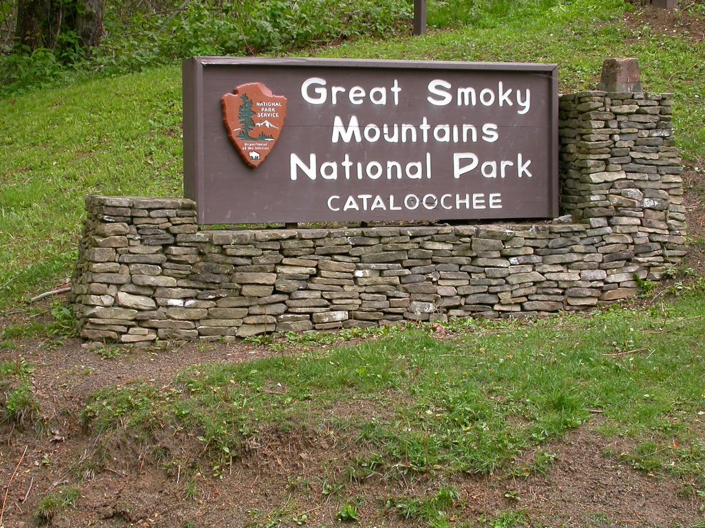
Bob White covered bridge, Patrick County, Virginia; 80', 1920, closed to motor traffic.

In my lifetime, covered bridges have been seen largely as romantic structures of a more quixotic time. However, nowadays I believe by all but the oldest third of our population they are thought of only as historical landmarks, but what was the original purpose of covering bridges? Many reasons have been suggested over the years for why bridges were covered, and even though most were practical or romantic, not all of these ideas were correct from a truly practical stand point. One explanation was that "the spans were built to resemble barns so farm animals would feel more at home and not stampede as they were driven across the rushing waters." Other explanations included: to keep snow off the bridge, "to keep the oiled planks of the roadbed from becoming dangerously slippery in the rain," to cover up the unsightly trusses, to provide shelter to travelers caught in a storm, and to provide a place to court your lady and secretly give her a kiss.

Covered bridges did serve many of these purposes other than simply providing a way to cross a river. Weddings, political rallies, National Guard drills, religious meetings, a night’s sleep for tramps, town meetings, poker parties, election headquarters, sweethearts’ rendezvous, drunken revels, bond rallies, fights and dances, and rainy-day luncheons took place in covered bridges. They also served as good landmarks and advertisement billboards.

However, one real reason for covering bridges was to protect the trusses from the weather because the environment caused bridges to fail sooner. Bridge engineers pointed out that a housed timber truss span has a life expectancy at least three times greater than one un-housed. Another important consideration was that the housing provided a kind of insulation for the timber, shading it from the sun and maintaining it under more uniform temperature conditions.

Covered bridges can be dated back two thousand years to a time when they were being built in China and even earlier in ancient Babylon (780 B.C.). But the first covered bridge built in America was built in 1804 by Theodore Burr of Connecticut. This bridge spanned the Hudson River in New York and was called the Waterford Bridge, lasting for 105 years.

In Virginia, covered bridges began to dot the countryside nearly two centuries ago. Spanning rivers and streams, their number grew to the hundreds. However, relatively few of Virginia’s covered bridges survived into the early years of the 20th century. Here are a few:

Bob White Bridge
The Bob White Bridge in Patrick County is an 80-foot truss over the Smith River near Route 8 south of Woolwine. Built in 1921, it served principally as a connection between Route 8 and a church on the south side of the river. Although it has been replaced with a modern bridge, visitors can still walk up to the Bob White Bridge, which was retained for its landmark value.
It can be reached from Woolwine by traveling 1.5 miles south on Route 8, east one mile on Route 618 to Route 869, then south one-tenth of a mile.

Jack's Creek Bridge
Jack's Creek Bridge crosses the Smith River in Patrick County on Route 615 just west of Route 8 about two miles south of Woolwine. The 48-foot span, built in 1914, has been replaced by a modern bridge but is being retained in the county.
It can be seen from Route 8 at its intersection with Route 615, or it can be reached by turning west two-tenths of a mile on Route 615.

Humpback Bridge
In terms of seniority, the venerable Humpback Bridge lays claim to being the oldest of Virginia's remaining covered bridges. Located in Alleghany County, just west of Covington, it was built in 1857. It was part of the James River & Kanawha Turnpike (JR&KT) and it succeeds three other bridges at the site. It stretches over Dunlap Creek, which is a tributary of the Jackson River that joins the Cowpasture River, near Iron Gate to form the James River. The first structure was built in the 1820s and was washed away by a flood on May 12, 1837. The second fell victim to the flood of July 13, 1842 and the third, as the annual report of the JR&KT company put it, "gave way" in 1856.

The 100-foot-long, single-span structure is four feet higher at its center than it is at either end, thus the name, "Humpback". Traffic across the bridge ceased in 1929 when it was replaced with a "modern" steel truss bridge. It stood derelict (and was even used by a nearby farmer to store hay) until 1954. That year, thanks to the fund-raising efforts of the Business and Professional Women's Club of Covington and the Covington Chamber of Commerce, it was restored and preserved as part of Alleghany County's history.
It can be reached from I-64 by taking exit 10 to Route 60 and traveling one-half mile east, or by taking Route 60 west from Covington.

Sinking Creek Bridge
In Giles County north of Route 460 are two circa 1916, modified Howe trusses built over Sinking Creek.

Sinking Creek Bridge (also known as Clover Hollow Bridge), a 70-foot span currently maintained by Giles County, was left in place for the property owner when a new bridge was built in 1949. It is located just off Route 601 between Route 42 and Route 700. A 55-foot span, known as Link's Farm (Bradley) Bridge, stands on private property nearby.
Also in Giles County is the C.K. Reynolds Covered Bridge, which still remains on private property. The Biedler Farm Bridge in Rockingham County, also remains on private property.

Meem's Bottom Bridge
One of the best-known covered bridges is the 204-foot single-span Burr arch truss known as Meem's Bottom in Shenandoah County. Here it is possible to step back into the past, while less than a half-mile away the hum of modern-day traffic can be heard on I-81.

The site takes its name from the Meem family that owned large landholdings in the area. This long span over the North Fork of the river carried traffic for more than 80 years before being burned by vandals on Halloween 1976.

After salvaging the original timbers, the bridge was reconstructed and eventually undergirded with steel beams and concrete piers.

Succeeding several earlier bridges, the Meem's Bottom Bridge was built in 1894 from materials cut and quarried nearby for the massive arch supports and stone abutments, which extended 10 feet below the riverbed. Records show that previous bridges were washed away in the floods of 1870 and 1877. The next bridge, built in 1878, stood until replaced by the present bridge.
The bridge is reached easily from I-81 at exit 269 between New Market and Mount Jackson, following Route 730 from the interchange four-tenths of a mile to Route 11, then north on Route 11 nine-tenths of a mile to Route 720 and west a short distance to the river. It also can be reached on Route 11 four miles north of New Market and about two miles south of Mount Jackson.

Today in Virginia, only eight covered bridges are known to still stand. Five have been preserved as landmarks and three are on private property.

C.K. Reynolds Covered Bridge, Giles County.
Biedler Farm Bridge, Rockingham County.
Links Farm Bridge, Giles County.

For more information on Virginia’s covered bridges click here.

Images: from, Virginia Department of Transportation

Technorati Tags:

A Lesson From Creation


It was a beautiful Saturday morning. Bright, clear skies with lots of sunshine. Quite warm in the sunlight, but with a persistent cool breeze blowing. It was a perfect morning for almost everything - everything but photography. The bright sunlight was way too contrasty for the waterfall I was trying to photograph, and the breeze was swaying all the wildflowers too much for a sharp capture. But as Thoreau once said, "The question is not what you look at, but what you see." Remembering that advice, I began to search for smaller details in more shelterd areas of open shade where the breeze was less, and the light more even. This tiny cascade might go unnoticed by many in the shadow of the great falls above it, but if we will just look, we will see it has it's own beauty. A lot of things in life are like that.

Tuesday, May 30, 2006

The Lowly Locust

Black Locust Tree on Blue Ridge Parkway, image by L. Shelor

Throughout the mountains there is a small tree that grows along the edges of fields, sometimes out in the open, in the woods and along the streams. It attracts little attention, except in the spring, when it puts forth lacy white blooms. Often these blooms are modest; green tinged and lost in the rich greens and silvers of spring's sudden new growth. But sometimes the trees are covered with lacy white blossoms, and a sweet scent hangs over the mountains, from the bloom of the locust tree.

Some years the locust bloom rivals the dogwood and serviceberry in abundance. The unsung beauty of the locust bloom supplies nectar for honeybees and hummingbirds. There are several varieties of locust in the Blue Ridge Mountains. The honey locust (Gleditsia triacanthos f. inermis) has large thorns and lacy foliage. Named for the sweetness of their foot long seed pods, the honey locust is a short-lived tree that grows quickly, reaching heights of 66 to 100 feet. Native Americans used the sweet pulp of this legume as a food, and it can be made into beer. Wealthy English landowners commissioned colonial plant hunters to find exotic species for their estates, and the honey locust was a favorite find. The long, hard thorns were used by early settlers as nails, and the wood from this tree is of high quality, durable and will polish well, although the tree is not common enough to sustain a large timber industry.

The clammy locust, discovered in South Carolina in 1776 by botantist William Bertram, also grows in some parts of the Blue Ridge. A small tree or shrub, the clammy locust can be recognized by a sticky or clammy secretion of the gland hairs. It also often has thorns, and showy pink flowers.

Black Locust Bloom, image by L. Shelor

The variety of locust in the middle part of the Blue Ridge Mountains is the Black Locust (Robinia pseudoacacia). A common tree in this part of the country, growing from seed and often sending up new sprouts from roots and stumps, the locust grows to 80 feet and is relatively short-lived, rarely making it to 100 years. It has compound leaves, with paired leaflets that are rounded and also has short thorns on the twigs near the leaves. Seed pods in the fall provide food for deer, squirrels and other animals. The seeds are toxic and children have reportedly been poisoned by chewing on the leaves or bark.

The black locust is considered invasive by some people, and it will send up hundreds of spreading shoots after being cut down. But it was a valuable tree to the early settlers. Locust wood provided wood heat for mountain cabins, and has long been the preferred wood for fence posts, especially since the loss of the American chestnut. A durable wood, it has been used for everything from mining timbers to railroad ties commercially, and provided the settlers of the Blue Ridge Mountains with lumber for wheels, wagon bottoms and gates, and was probably used anywhere that required a strong wood that would resist rot and decay. Although black locust has an attractive straight grain, it is far more valued as a utilitarian wood rather than as a decorative one. It has a greenish-yellow tint when first cut but deepens into a golden color.

Black locust in the Blue Ridge mountains is often infected with the locust borer. Depending on conditions, trees are either stunted or killed, and often large stands of locust will show signs of the infection, especially during drought and heat. The browned leaves of the locust attacked by the borer stand out in late summer against the green of other trees across the mountains.

Valued by some and regarded as a nuisance by others, attacked by pest and axe, the locust tree survives and often thrives under conditions that would discourage many dainty cultivars. Like the early settlers that used the wood, the locust tree is a symbol of tenacity under adversity.

Monday, May 29, 2006

In The Mountains, It's Barbeque!

I don’t know if anyone has ever compiled statistics on how many people commemorate summer holidays like Memorial Day with barbeque, but if the aromas wafting through my part of town are any indicator, it’s a bunch. In backyards, at parks, on lakeshores, and picnic grounds, grills are a-blazin’ and meat is a-sizzlin’. Summer is barbeque time in the mountains.

Although there are varied opinions on what constitutes real barbeque, the popularity of meat cooked with wood smoke as the main flavor ingredient continues to grow. And that’s the common ground of barbeque from any region: smoke. Smoke from smoldering wood. No smoke, no barbeque. Some use all wood for their fire, others use real charcoal made from charred wood. Most probably use charcoal briquettes with wood chips or chunks smoldering on top. Whatever the method, barbeque requires smoke.

I once ate a restaurant in Laredo, TX that was widely famous for it’s ribs. The ribs were tender, moist without being greasy, expertly seasoned, served with a delicious sauce, but didn’t have even a hint of the smoky flavor that marks true barbeque. I found out later that this restaurant used a specially made electric “barbeque” cooker. They were great ribs, but without smoke, it just wasn’t barbeque.

While smoke is the common denominator, there’s a lot of debate about which sauce is appropriate. Here in the mountains of western North Carolina, three regional preferences for sauce collide. In the eastern part of the state, a vinegar-based sauce is the norm, and many on this end of the state agree it’s the best. From nearby South Carolina, a mustard-based sauce has found its fans locally. And finally, a tomato-based sauce as is more common in Texas and Tennessee is also popular with folks around here. Many a good natured argument takes place around local grills when the subject of the best sauce comes up.

And then there’s the question of what kind of meat should be used. In Texas, barbeque means beef, and usually brisket. Memphis and Kansas City both claim their fame from pork ribs. Here in the Carolinas, pork shoulder, pulled and served on buns is what most people think of as barbeque. Why limit yourself to just one? In the mountains where I live, we enjoy them all, and also include chicken, sausage, and even fish as suitable fare for the grill.

Whatever your preference in meat may be, real barbeque involves cooking at relatively low temperatures (less than 300 degrees) for a long period of time. This “low and slow” method of cooking gives barbeque its unique flavor, and also tenderizes meats like brisket and ribs. Another benefit to this cooking method is that it provides plenty of time for folks to visit and enjoy each other’s company while the meat cooks. It affords a welcome break from the hurried and harried existence many of us live during the week. Not feeling up to having guests over? Then how about a nap, or that book you’ve been meaning to read? With barbeque, you’ve got time.

Memorial Day is about over as I write this, but it’s only the beginning of a long, summer barbeque season. Traditional holidays like July 4th, and Labor Day practically demand barbeque around here, but any weekend is a good time for some ‘que. So roll out that grill, slap on your preferred meat with your favorite sauce, and invite some friends over for a relaxing evening of food and fun. Because in the mountains, it’s barbeque!

Take a Ride on the Georgia Mountain Parkway


Wildflowers in bloom on the Georgia Mountain Parkway

You will enjoy the breathtaking scenic beauty along the Georgia Mountain Parkway as you travel along the Zell Miller Parkway (Hwy 515/76) north from Atlanta’s Highway 575, which becomes Highway 515 to the North Georgia Mountains. The Georgia Mountain Parkway begins in Pickens County, gently climbing up Highway 515/76 through Gilmer, Fannin, Union, and into Towns Counties. The Georgia Mountain Parkway travels through the Southern Appalachian towns of Jasper, Talking Rock, Ellijay, Blue Ridge, McCaysville, Blairsville, Young Harris and Hiawassee.

Mountains of outdoor activities in the Chattahoochee National Forest await you along the highway such as: hiking, biking, whitewater rafting, tubing, fishing, and swimming. Along with scenic mountain views, the Georgia Mountain Parkway provides local flavor at a variety of dining establishments; shopping in quaint mountain craft, antique and art galleries & shops; accommodations at luxurious mountain resorts, cozy cabins or bed & breakfasts; and a plethora of country festivals featuring Appalachian culture through products such as apples, crafts, marble, and bluegrass and country music.


Technorati Tags:

Drive the Hunter's Raid Civil War Trail


Click the map of the 'Hunter's Raid Civil War Trail' for a larger view.

On May 11, 1864, 257 Virginia Military Institute cadets marched 84 miles to New Market, VA to take part in the Battle of New Market. Their valiant efforts cost a dear price as 10 cadets lost their lives and another 45 were wounded. The corps, however, was instrumental in turning the battle to defeat Union General David Hunter’s regiment. In retaliation, General Hunter brought forces 18,000 strong into Lexington, home of VMI. The Institute was considered a legitimate military target, as it was both an arsenal and a military training school. On June 12, Hunter ordered VMI burned.

On May 26, 1864, Union Gen. David Hunter marched south from Cedar Creek near Winchester to drive out Confederate forces, lay waste to the Shenandoah Valley, and destroy the railroads at Lynchburg. His raid was part of Gen. Ulysses S. Grant's strategy to attack Confederates simultaneously throughout Virginia. After defeating Gen. William E. “Grumble” Jones at Piedmont on June 5, Hunter marched to Lexington, burned Virginia Military Institute, and headed to Lynchburg. There, on June 17–18, Gen. Jubal A. Early repulsed Hunter and pursued him to West Virginia. Early then turned north in July to threaten Washington.


Now you can drive at your leisure and visit all of the historic places that, "The Hunter’s Raid Civil War Trail" will take you.

The Hunter’s Raid Civil War Trail is a scenic driving tour of Union General David Hunter’s 1864 raid through the Shenandoah Valley. Detailed trail markers may be found along the way.

Technorati Tags:

Saturday, May 27, 2006

The National D-Day Memorial


Memorializing the Fallen of June 6, 1944

The National D-Day Memorial is a solemn yet powerful reminder that the freedoms we enjoy today were secured at a cost. Soldiers, sailors, and airmen embarking upon the "Great Crusade" realized the singular importance of their mission on D-Day. They also realized its many dangers. Nearly 4,500 Allied and American troops lost their lives on 6 June 1944. Their names, engraved on tablets encircling the middle plaza, remind visitors of the individual sacrifices troops made on that fateful day in Normandy. The National D-Day Memorial Foundation is dedicated to preserving their legacy.

* Soldiers & Sailors at Worship:
A Field Chapel Service, c. 1944 *May 28, 2006 - 9:00am

Even in combat, many troops made time for their faith. The 29th Living History Association will conduct a period church service as seen in the field during World War II. Bring your own chair and see how it was done. Regular fees apply.

* Uniting in Remembrance
* May 29, 2006 - 11am

To observe Memorial Day, the Memorial will have a wreath-laying ceremony to pay tribute to those who have given their lives in service to our nation. The ceremony includes music, special speakers, and the dedication of new plaques recognizing those who were killed during the Normandy invasion as well as new narrative plaques describing the contributions of others. The Memorial will also dedicate a full bronze statue of General Dwight D. Eisenhower. The statue is the latest addition to the Memorial. Free admission until noon.

* 62nd Anniversary of D-Day
* June 6, 2006 - 11am

Spend the 62nd anniversary of D-Day at the National D-Day Memorial where valor, fidelity, and sacrifice are honored everyday. Pay tribute to those soldiers who made the ultimate sacrifice in Normandy 62 years ago and honor those veterans who lived to fight another day. There will be a brief ceremony at the site. Selective members of the crew of the USS Normandy will be represented including Command Chaplain Lt. Robert N. Burns, Jr. The Enduring Freedom Honor Team will also perform while dressed in period attire. The Memorial will have tours throughout the day. Regular fees apply.

Hours of Operation:

Memorial Hours: Open from 10:00 AM through 5:00 PM daily. Closing at 3pm Christmas Eve, Closed on Christmas Day, New Year's Day, and Thanksgiving Day. Openings before or after normal operating hours by special arrangement for the additional fees listed below under Special Openings.

Memorial Store: Open from 10:00 AM through 5:00 PM daily. Closing at 3pm Christmas Eve, Closed on Christmas Day, New Year's Day, and Thanksgiving Day. Closed January 2 for inventory.

Foundation Office Hours: Open Monday through Friday from 9:00 AM through 5:00 PM. Closed on Christmas Day, New Year's Day, and Thanksgiving Day; other holiday closings may occur. When in doubt, telephone to confirm opening before visiting the Foundation Office.

Admission Fees: The National D-Day Memorial is a private, non-profit organization that receives no federal funding. All fees go toward the operation and security of the site so that it can be properly preserved and maintained for future generations.

Regular Entry Fee:
$5.00 per adult
$3.00 per child (ages 6-16)
Under 6 - free

Location:

The National D-Day Memorial is located at the interchange of Routes 460 Bypass and 122, in the city of Bedford, between Roanoke and Lynchburg, Virginia. Access to Interstate 81 and 29 from Route 460 are within 20 miles of the Memorial. You may view this location using the MapQuest map service.

Images and info from, The National D-Day Memorial online.


Technorati Tags:

A Painful Legacy “The Old City Cemetery”


When you first drive in to the Lynchburg, Virginia’s, Old City Cemetery you get the feeling that you have entered just another old graveyard. However, once you park and begin to explore you soon find out that this “old cemetery” is not just any old cemetery. Instead, it is engulfed in history, the history of a sad and painful time in American history; the Civil War era.

The Station House Museum tells the story of the railroad during the era and its importance to the areas economy, life and death of Lynchburg residents and the rails importance to the soldiers of WW 1 (1917-1919) that passed through Lynchburg on their way to the coast and the war. These soldiers dubbed Lynchburg, “Lunchburg”, because of the hospitality of the Red Cross Canteen service which provided these soldiers with food and drink on their stop in Lynchburg.

The three major railroads that ran through Lynchburg in1864, turned the city in to a regional hub of industry and tobacco and made it one of the wealthiest cities per capita in the United States. During the Civil War, the railroads made Lynchburg the second largest hospital center in Virginia.

The Hearse House tells another part of a devastating and sad time. Across the cobble stone road, resting on a hill is the Pest House Medical Museum, one look inside reveals the crudity of medicine during the time. One can only imagine the screams of pain of a recent amputee and impending infection which followed. You can sense the overwhelming adversity endured by not only the Pest House patients but of Dr. Terrell, Rev. Louis and the missionaries that ministered to the “spiritual and medical needs of patients. During the Smallpox epidemic of 1862-1864, it is said that no one but these brave and hardy souls were the only ones that would go near the place.

Entering the Confederate Cemetery and seeing the rows of markers, over 2200, a good number of which are unmarked, you can’t help but feel how painful it was for the families of these lost soldiers: not only eventually knowing that their loved one had likely died, but where they had died, and where there remains rested as well as never having any real closure.

In the Confederate Cemetery, soldiers from fourteen states rest there, from Virginia to Florida, west to Texas. One-hundred eighty-seven Union soldiers (prisoners) died in Lynchburg Hospitals and were buried in the cemetery until 1866 when they were removed by the Federal Government and ordered to a Federal Cemetery near Norfolk Virginia.

The gardens, selected trees and the old brick walls, among other things lend a rejuvenation of life that helps, if only briefly, relieve some of the pain of America’s reflective history.


Technorati Tags:

Friday, May 26, 2006

Roan Mountain

At an elevation of 6,285 feet on the Tennessee-North Carolina border, Roan Mountain has been a popular destination for explorers, botanists and naturalist for hundreds of years. Legend tells a story if Indians coming to the top of the Roan to wage a great battle and that so much blood was spilled that the rhododendron turned from pure white to a brilliant red. Spanish explorers came to the mountain looking for gold and world renowned botanists came looking for exotic species of plants. In the late 1800's the wealthy came to the magnificent Cloudland Hotel to take in the cool mountain air. Often the peak of the Roam will be above the clouds which gave rise to the the name of “Cloudland”.

Andre Michaux, the world famous botanist who documented plant species on Grandfather Mountain in 1794 while on an expedition for Louis XVI and Marie Antoinette of France also documented plant species on Roan Mountain. Michaux's expeditions to the mountains of the Carolinas were especially fruitful. In this remote region he ascended many of the highest peaks. To reach the summits of Grandfather Mountain, Roan Mountain, the Black Mountains, the unique peaks of Table Rock and Hawksbill, and many other mountains the indomitable explorer followed his local guides on routes traveled only by hunters.

The Roan is probably best know today for the rhododendron gardens that will soon be in full bloom. The Roan is considered to be in a “Canadian Zone” which basically for most of us means that blooming comes late in the season for native plants at this elevation. Usually mid to late June is the best time to plan a visit to the mountain to see the rhododendron display in all it's glory. The Roan has a special place in the hearts of many who visit and live here hence the popularity of the Rhododendron Festival being in the 60th year held on Sat. and Sun., June 17-18, 2006, from 10 a.m. till 5 p.m., outdoors at Roan Mountain State Park in the swimming pool and amphitheater area. Be prepared, I have been on top of the Roan in June and witnessed cross country skiers passing by on their way down the mountain. Needless to say, the weather is king when on the high exposed peaks in the Blue Ridge.

The Roan Mountain State Park is part of the Tennessee State Parks system and was created in the 1950s and developed in the 1970s. Boasting one of the finest campgrounds in the county and modern cabins available to rent, this campground is set against some of the most spectacular scenery in the Eastern U.S. With hiking trails, swimming, tennis, children's play areas and an amphitheater where several events and concerts are held throughout the season you will not find yourself trying to fill your free time with idle activities here. There is always something going on when you are in the mountains. This tends to be one of my biggest problems....so many mountains...so little time.

"It is the most beautiful of the high mountains... with Carolina at its feet on one side and Tennessee on the other, and a green ocean of mountains rising in tremendous billows around her."
-Dr. Elisha Mitchell,
(for whom Mt. Mitchell is named)

Thursday, May 25, 2006

We Must Protect Our Wild Areas!


Image: by D L Ennis, View from the Blue Ridge Parkway, looking on to Arnold Valley.

Virginia’s publicly owned national forests contain some of the state’s rarest, most valuable wild lands. From clear mountain streams and deep woods to breathtaking Blue Ridge views and abundant wildlife, the wilderness of the Old Dominion is priceless, and it’s there for us all to enjoy.

Most of us think of the benefits of wild places first in terms of recreation, of somewhere to get away from it all. Virginia’s wilderness offers ample opportunities to escape the pressures of daily life; it’s a great place for recreation, whether you are a hunter, an angler, a camper, kayaker, birder, rock climber or just looking for a walk in the woods. But not all of the places that Virginians love are protected; unless officially designated as wilderness, even those areas within national parks are vulnerable to logging, mining, and development.

Image: by D L Ennis, Waterfall in the George Washington National Forest.

But the value of wilderness goes beyond recreation. Wilderness areas protect the watersheds we rely on for clean drinking water. They prevent soil erosion, help clean the air, and preserve critical wildlife habitat. These areas also help vitalize local economies by attracting outdoor enthusiasts and protecting the scenic backdrop for many communities. Setting aside wild lands for permanent protection ensures a natural legacy for future generations.

Virginia, with its extensive national forests in the mountains and Shenandoah National Park, has much undeveloped federal land. Yet even these public lands, which are generally thought of as intended for wilderness, are increasingly and continually threatened with development of all kinds, whether logging, mining, road building, resort construction, or river damming. Many of these man-made industries are desirable in themselves (at the proper time and location), but they inevitably destroy the wild character of the area. It has become more and more apparent, as our population grows and our mechanical ability to alter the face of the earth becomes ever more powerful, that if we are to have any wild places left of significant size, we will deliberately have to plan and act with that objective.

For more information: http://VirginiaWilderness.org


Technorati Tags:

Apple Orchard Mountain and Falls


Rising almost 3000 feet above Arnold Valley, Apple Orchard Mountain is the highest point on the Blue Ridge Parkway in Virginia (4226'), as well as being the most topographically prominent mountain in the state.

Atop the summit is an FAA radar dome and as a result the mountain recognizable from miles away. There is an Air Force road to the summit which is strictly off limits, and the only access is via the Appalachian Trail. The easiest approach is to park alongside the Blue Ridge Parkway and hike along the A.T. to the summit. It is 2 miles round trip, with 300' of elevation gain.

Apple Orchard Mountain got its name from the red oak trees growing atop the peak, which look like an apple orchard from the distance. There are also no shrubs atop the peak, and that adds to the orchard appearance.

From Sunset Field overlook, at milepost 78.7 on the Blue Ridge Parkway you can access the Apple Orchard Falls trail. Here you will find a 200-foot-high waterfall that tumbles from the west side of Apple Orchard Mountain. The waterfall is accessible only by foot, and it's a strenuous hike via the Apple Orchard Falls Trail, a 1.4-mile hike one-way downhill. The trail starts at 3,500 feet elevation and loses 1,000 feet in elevation and crosses two old timber roads before reaching the falls.

There is a footbridge at the upper edge of the falls, but you have to continue to the bottom to fully appreciate Apple Orchard Falls. The stream, on the headwaters of North Creek, drops over several rocky steps and through several log jams before free-falling from an overhang. At the base, the water squeezes between giant boulders before flowing off into an isolated mountain valley.

The hiker may begin either at Sunset Field Overlook on the Parkway or at the end of FR 59, but the recommended hike begins at the end of FR 59 on Cornelius Creek Trail. This trail offers a gentler ascent than the Apple Orchard Falls Trail. The loop may be joined by using the Appalachian Trail (about 6 to 7 hrs) or Apple Orchard Spur, an old road (about 5 hrs.).


Images: courtesy of the National Forest Service


Technorati Tags:

Wednesday, May 24, 2006

Hot Dog Lunch


Road Log Excerpt
Yancey County, NC
Friday 10 July

"…turn west on Cr1340. A one-track tan dirt road, thru a gate next to a barn and up a residential hollow. This road looks more like a private lane. I'm watched suspiciously by front porch sitters. Climbing along the stony track, bob wire fence on the right, snakeroot on the left standing tall. Hardscrabble thickets and brush. Huge Christmas trees overgrown, never harvested for market. Abandoned pickups, covered with honeysuckle, rusting beside the road. Down a steep decline framed by ridges in front, wild potato vine blossoms dangle from a rusty wire. A narrow hollow compresses to a tight squeeze. A hairpin around a tarpaper shack. Juvenile rabbits zigzag madly scrambling for the nearest ditch. It's 10 mph, bounce and rumble over the roughened stones. My eyes water, my nose drips rudely. Beagle's back glass is covered with a thick layer of dust. Stop. I stroll across a one-lane bridge and photograph an old sawmill; another shot down the railroad tracks. Then pause before a handwritten notice - a single sheet of erasable typing paper thumb-tacked to a wooden sign post…"

Bradshaw Fire & Rescue
Will be Hosting an Attic

Sale and Hot Dog Lunch
Sat. July 4th at the
Fire Dept. Site
Enjoy the Day with Us

Hit and Miss in the Mountains

Hit and Miss in the Mountains
Antique Engine Show
May 27, 28, 29, 2006
Come join us in beautiful Meadows of Dan for a Memorial Day Festival of special events and activities. Over 24 antique engines displayed, including and antique ice cream maker, grist mill, restored trucks and tractors, and many more. 16 craft vendors and craft demonstrations, food vendors and music. For more information visit Mountain Meadows Farm and Craft Market.

From "Warm Springs" to "Hot Springs"

Hot Springs, North Carolina, has been a resort destination since the early 1800's and has long been renowned for its healing mineral springs and scenic mountain setting. Nestled on the banks of the French Broad River, Hot Springs has a lot to offer the outdoorsy minded types like myself. The Cherokee and Catawba Indians were the first to discover the 100-plus degree mineral water from which the Town of Hot Springs got its name. Colony traders came next, and by 1778 word was spreading that the mineral water from this area was healing the lame and sick. Travelers began climbing over the mountains to the hot springs to be healed of various illnesses. On March 19, 1791, William Nelson bought the hot springs property for "two hundred pounds in Virginia currency" and then began the commercial operation of charging a fee for a sitting in the mineral baths.

In 1828 the Buncombe Turnpike was completed through the town of “Warm Springs” thereby connecting Tennessee and Kentucky to the East Coast. This narrow winding mountain road was considered to be a super highway in it's day and was use by farmers who drove thousands of horses, cattle and hogs to market in Charleston South Carolina. and Augusta Georgia stopping to take in the waters along the way.

In 1831 James Patton saw the potential for a resort location and bought the property and by 1837 had completed the “Warm Springs Hotel” with 350 rooms and thirteen columns on the outside commemorating the thirteen colonies. It was soon given the nickname of “Patton's Whitehouse” due to it's enormous size and grandeur. The dining room was able to hold 600 people in comfort and the ballroom was then the second largest in the state.

The property was again sold in 1862 and purchased by James H. Rumbough, a wealthy stage coach operator. It was during the ownership of Rumbough that the son of then president Andrew Johnson (Frank Johnson) met his bride Bessie Rumbough (daughter of he owner).

The railroad came to town in 1882 and Rumbough then saw an opportunity for enlarging his hotel. Two years later the hotel burned and much of the town, springs and resort property were sold to the Southern Improvement Company which was owned by a northern interests. In 1886 the Mountain Park Hotel was built and a spring with a higher temperature was discovered which prompted the residents to decide to change the name from Warm Springs to Hot Springs.

The Mountain Park Hotel was one of the most elegant resorts in the country during it's operational lifetime. The hotel consisted of 200 rooms, barn and stables, springhouse and a bathhouse consisting of sixteen marble tubs surrounded by landscaped lawns with tennis and croquet courts. The hotel was home to the first organized golfing club ion the Southeast with a nine hole course.

By 1917 the resort was being used less and less by visitors and profits were down which brought about the decision to lease the property to the government to house German merchant sailors captured in U.S harbors when war was declared. Once the war was over, several of the prisoners returned to Hot Springs to visit due the the hospitality of the townspeople while they were held there. After the war the Mountain Park Hotel never was able to regain the popularity it once had before the war. In 1920 yet another fire claimed this glorious resort hotel and was never rebuilt. Over the next forty years two other hotels were built on the resort property and they both fell victim to the flame. Now the town of Hot Springs is all but forgotten as a resort community and tourism destination for travelers.

Today the mineral hot springs are enjoyed by locals, hikers, campers and travelers who seek adventure on the road less traveled. The Appalachian Trail runs through the heart of Hot Springs before it then sneaks back into the mountains and climbs to the ridge tops and continues on. Hot Springs hosts several festivals throughout the year that do attract many visitors and trail hikers who find Hot Springs a quite place to stop and rest and gather supplies before moving on. Trail Fest has been held for eleven years in Hot Springs and has been heralded as one of the top outdoor related festivals in the country. The Bluff Mountain Music Festival is held on the grounds of the resort property and also is in it's eleventh year. The French Broad River Festival has been on the must do list of many paddlers for nine years.

It only stands to reason that Hot Springs would be situated near some sort of geological activity giving rise to the warm water that makes the area so famous. In 2005 an earthquake measuring 3.8 on the Richter scales struck on the Tennessee\North Carolina border centered near Hot Springs. The quake was felt as far away as Atlanta, Georgia, about 170 miles away. Although this may seem like an unusual location for earthquakes, minor quakes in this area are not uncommon. The largest earthquake in the area (magnitude 5.1) occurred in 1916 . Since 1971 This 100 mile area has seen 77 earthquakes at or above 2.0. A dozen of these quakes were 3.0 or larger. This most recent quake has been the largest telling me that we are leading up to something pretty big in the future.

The hey day of this little diamond of a town may be over in the eyes of historians, but in my eyes and heart Hot Springs is definitely one of the most exciting places I have ever been to sit back and do nothing other than let the mountains surround me in peace and quite. The wife and I love to jump over the mountain several times throughout the year to have a soak in the crystal clear naturally carbonated water on the very same grounds that once attracted the most elite and well-to-do citizens of our country.

Time travel back to the 1700’s


Time travel back to the 1700’s to see what life was really like for working farmers. Visit the Claude Moore Colonial Farm at Turkey Run in Northern Virginia where you will step into a living history museum that portrays family life on a small, low-income farm just prior to the Revolutionary War.

This from the National Park Service:


Claude Moore Colonial Farm is a living history site that demonstrates the life of a poor farm family living on a small farm in northern Virginia just prior to the American Revolutionary War. Today, agricultural and household activities seen on the Farm represent an earlier era when small farms were dispersed throughout the countryside; and, most Americans engaged in activities of an agricultural nature.

The farmer's property includes twelve acres planted with corn, tobacco, wheat, flax, rye, barley, a kitchen garden and an orchard. The fields are tilled, planted and cultivated by hand, applying basic principles of hoe agriculture. The farmer allows his livestock to roam freely, protecting valuable crops with split rail fencing. The small log house is used as the family dwelling, where meals are prepared over the hearth fire using food raised on the Farm. Clothing, furniture, tools, and equipment used by the Farm family are reproductions of 18th-century artifacts.

Staff and volunteers dressed in reproduction period clothes, work the farm, and answer your questions about the farm, livestock, and family, as if you were actually an 18th century visitor. The Farm is managed and operated by the Friends of Claude Moore Colonial Farm, at Turkey Run, Inc. through a cooperative agreement with the National Park Service, George Washington Memorial Parkway.


The Claude Moore Colonial Farm
6310 Georgetown Pike
McLean, VA 22101
703-442-7557

Park Open April through mid-December

Farm Hours: Wednesday - Sunday10:00 a.m. - 4:30 p.m
GateHouse Shop Hours: Wednesday - Sunday10:00 a.m. - 5 p.m.
(Farm and Shop both closed Monday and Tuesday)

Regular Admission:$3 for adults;
$2.00 for children (3-12 years old) and senior citizens

No pets are allowed on the Farm property.

Directions:
Just off the Capital Beltway (I-495) at the intersection of
Georgetown Pike (Rte. 193) and Dolly Madison Blvd. (Rte. 123).
About 20 minutes from Washington, D.C. or downtown Alexandria.

For more information click here.

Images from: http://www.1771.org/


Technorati Tags:

Tuesday, May 23, 2006

Birds of the Mid-Atlantic #11: Bobolink

A flock of small dark birds suddenly rises out of a field with a chirping, bubbling call. Just as quickly, the flock settles back down in a different part of the field. What were they?

In my city of Washington, DC, a flock matching this description is most likely to be starlings, or perhaps one of the common species from the blackbird family. At this time of year, however, it is good to check such a flock for bobolinks. This species now occurs in DC only during migration. In the ridge and valley province of western Maryland and Virginia, bobolinks breed in hay fields.

Bobolinks are members of the icterids, the diverse family that includes blackbirds and grackles, meadowlarks, and orioles. A male bobolink is mostly black, but has a cream-colored patch on the back of its head, a large white rump, and broad white stripes where its wings meet its body (i.e., white scapulars). Females are sparrow-like in coloration, with dark brown wings, buffy bodies, and dark brown cap and eyestripe.

Bobolink / Photo by S. Maslowski (USFWS)

The distinctive appearance of this species has given rise to colorful nicknames. "Butter-bird" and "skunk blackbird" came about because of the white and cream-colored patches on its back and head. The appellation "ricebird" notes bobolinks' affection for grassy meadows and wild rice patches.

Since bobolinks spend much of their time foraging on the ground, one needs to be ready to spot them in flight. Luckily, several factors make this easier, if you know to look for them. Bobolinks are a highly social species, and travel in flocks, like cedar waxwings and some blackbirds. Such a flock is itself a clue that bobolinks may be present. In flight, the contrast in coloration between males and females is quite striking; look for flocks that include both black and light brown birds. The white patches on the otherwise black makes stand out quite readily if you see the birds from the side or rear. In addition, the song of the bobolink, frequently is helpful if you recognize it. Unfortunately I do not, but you can listen to samples here and here, as well as at the CLO site.

Like other grassland species, bobolinks have declined due to loss of habitat. This can be attributed to changes in agricultural practices, development of former farmland into suburban housing, and former fields being overtaken by woody vegetation. One solution that individual farmers can implement is to delay summer mowing from June until late July, after most nestlings have fledged. Such action would benefit not only bobolinks, but also other grassland species such as grasshopper sparrows and eastern meadowlarks. Grasslands managed for bobolinks should be mowed or burned at least every two years to reduce woody plants.

Tags:

Labels:

We are looking for writers!

We are looking for writers! The Blue Ridge Gazette blog is a not for profit venture so currently we can't pay for articles that appear on the blog. However, we have put together an online magazine (zine) and our readership continues to grow, both on the blog and the zine!

Here is what we want: We want writers who are able and willing to post at least once a week, on the blog, on the subject of the Blue Ridge Mountains; the best articles from the blog are selected each month to appear in the following month's zine. If you are able to do this and stay with it long enough for the zine to start producing some income then you will be paid, in accordance with that income, for your articles which appear in the zine.

We are trying to build something and it takes time and dedicated people to make it work!

If you would be interested in getting in on the ground floor of this project and are able to help by working hard, within reason, and can be patient you could and hopefully will start earning an income from your writing!

If interested, you can email us here.

Let me just add: Each contributor retains all rights to what they write; we have no desire to copyright your material!

Monday, May 22, 2006

The Wild Man of Cataloochee

This story has become my family's personal ghost tale of sorts, told around a campfire (or, when I was still a kid, at my friend, Laura's request for her slumber parties). My brothers, being older than I, may have a different take, but, with a little bit of added information from my parents, this is how I remember meeting...The Wild Man of Cataloochee.

When we were kids, my family spent a great deal of time in the woods, on hikes, camping trips, picnics, fishing, etc. One of my dad's favorite places to camp was in the Great Smokies National Park, in the Cataloochee Valley (I've written previously of this beautiful place here). So it was really no surprise that one summer in the early seventies, we found ourselves in Cataloochee again. I was 6 or 7 years old, my brother Stephen was 7 or 8, and my brother, David, four years older, at 11 or 12.

It was the last day of our trip. We had been camping for a day or two and had visited all of the historic homes and barns we cared for. Dad stopped the station wagon at the bottom of an old dirt road, closed by the Park Service with a barrier. A ranger--a tall, red-headed man--stopped as we were piling out of the car. Dad asked him where the road went.

"Oh, it goes up there about a half-mile or so and there's an old cemetery you can visit," he said. "It's a nice walk through the woods." Dad chatted with him a while longer, then he tipped his hat at us, got into his truck, and left.

We started on our walk. My brothers, as they always did, ran ahead, joshing and shoving one another. I dawdled, as I often did, looking up into the trees or scoping the ground for just the right stick or stone or other treasure. My parents strolled easily along with us, talking lightly, or pointing out wildflowers, trees, and other objects of interest.

It was a lovely day and we were on a typical family walk in the woods.

Then my brothers decided to leave the trail. I don't know why (maybe to be goof-offs, maybe to water the trees). Looking ahead at them, I saw David stop and stare into a thicket of trees. Stephen nearly stumbled into him. They called to Dad, who joined them.

Suddenly Dad's demeanor changed. He turned and herded my brothers back toward where my mom and I stood, waiting, curious. His face was serious. I don't know if Mom saw whatever it was or she was struck by the tone in his voice as he said "Get the children to the car. Now." She responded with haste. We turned and half-ran down back down the path. Dad followed cautiously behind us, as a bodyguard.

"Did you see him?" David asked.

"Yeah, he was all pale and dirty," Stephen said.

"Who? What was it?" I asked, breathless, my heart pounding.

"He looked like he was crouching down to go to the bathroom," Stephen said.

"He was definitely watching us."

"Who was watching us?" I said, alarmed.

"Stop you two." My mom said, scolding. "Let's just get to the car."

We fell silent then, each imagining we heard heavy footsteps following in the woods beside and behind us.

We made it to the car, jumped in, and pressed our faces to the window, looking for Dad. He was quick behind us, sauntering boldly, carrying a huge limb on his shoulder. As he came out of the woods, he glanced behind him, shrugged the limb aside and climbed into the driver's seat. He exchanged a look with my mom, started the car, and drove away, three young faces watching out the back window for...someone to appear from the dark edge of the forest.

We talked about it for days, of course. Finally I was able to piece together the story.

David had seen him first--a face, watching us from the rhododendron thicket. He was grubby, his face dirty and clothes like rags hanging from his thin frame. He was crouching, as if hiding, and he was definitely watching us. To Dad and Mom, he was menacing.

They thought we must have stumbled upon some moonshine still, and they weren't about to stick around and learn what a mountain man might do to scare us away from such an operation. Dad had lagged behind in case anyone followed, and he had picked up the limb to use as a weapon, if necessary. He had a young family to protect, and the movie Deliverance had only recently premiered.

A few months later, we learned more when an interesting article appeared in the Asheville newspaper. On the front page there was a photo of the nice red-headed ranger we had spoken with, posing before an impromptu lean-to in the woods around Cataloochee. Someone had been living there--perhaps for years.

Turns out the man was "simple-minded," as the old folks say, and had left his family, who lived in the nearby Cove Creek community, to live off the land in the region settled by his ancestors. People of the community often left food out for him, and supplies. Once the story broke, visitors at the Cataloochee campground left him food, as well, until rangers put a stop to it because of bear activity.

As for my family, we were to encounter him again, a couple of years later.

This time, we had stopped along the barricaded road to pick wild strawberries which grew in abundance on the banks. As we worked our way along, eating as many as we saved, we noticed someone in the ditch a ways down and across the road.

He was grubby, his face dirty, and his clothes ragged and hanging on him. He was picking strawberries into a cloth sack.

This time, he wasn't menacing at all. In fact, he seemed nervous, casting furtive glances at us over his shoulder. He appeared to shrink smaller and smaller into his body as if trying to make himself disappear.

My brothers, full of the bravado of young boys, kept trying to get closer and closer. The man kept inching away.

"Boys!" my dad called, "Come on, now." He figured the man was better left without harassment from some city kids.

We tumbled into the station wagon, the three of us pressed to the back window for our last glimpse of The Wild Man of Cataloochee. Watching us over his stooped shoulder, he moved to the other side of the road where we had been picking berries only moments before.

It was the last time we ever saw him.

Sunday, May 21, 2006

Raccoon Branch


Raccoon Branch and this old barn remind me of pork tenderloin. The tastiest sizzling pork tenderloin scrambled eggs and crispy hash browns ever, served up with good cheer by Peggy Sexton proprietor of the Sugar Grove Diner a pleasant walk from here.


Sugar Grove, Virginia
Smyth County

Legend of the Cherokee Rose


Image: Cherokee Rose, Georgia State Flower

When gold was found in Georgia, the government forgot its treaties and drove the Cherokees to Oklahoma. One fourth of them died on the journey west. When the Trail of Tears started in 1838, the mothers of the Cherokee were grieving and crying so much, they were unable to help their children survive the journey. The elders prayed for a sign that would lift the mother’s spirits to give them strength. God, looking down from heaven, decided to commemorate the brave Cherokees and so, as the blood of the braves and the tears of the maidens dropped to the ground, he turned them into stone in the shape of a Cherokee Rose. The next day a beautiful rose began to grow where each of the mother’s tears fell. The rose is white for their tears; a gold center represents the gold taken from Cherokee lands, and seven leaves on each stem for the seven Cherokee clans. No better symbol exists of the pain and suffering of the "Trail Where They Cried" than the Cherokee Rose The wild Cherokee Rose grows along the route of the Trail of Tears into eastern Oklahoma today.


The Legend of the Cherokee Rose

More than 100 years ago, the Cherokee people were driven from their home mountains when the white men discovered gold in the mountains of North Carolina and Georgia. Their journey is remembered as the Trail of Tears. Some of the people came across Marengo County in West Alabama. It seems that after they had left the mountains, they came this far south so not have to climb more mountains.

It was early summer and very hot, and most of the time the people had to walk. Tempers were short and many times the soldiers were more like animal drivers than guides for the people. The men were so frustrated with the treatment of their women and children, and the soldiers were so harsh and frustrated that bad things often happened. When two men get angry they fight and once in a while men were killed on the trip. Many people died of much hardship. Much of the time the trip was hard and sad and the women wept for losing their homes and their dignity.
The old men knew that they must do something to help the women not to lose their strength in weeping. They knew the women would have to be very strong if they were to help the children survive.

So one night after they had made camp along the Trail of Tears, the old men sitting around the dying campfire called up to the Great One in Galunati (heaven) to help the people in their trouble. They told Him that the people were suffering and feared that the little ones would not survive to rebuild the Cherokee Nation.

The Great One said, "Yes, I have seen the sorrows of the women and I can help them to keep their strength to help the children. Tell the women in the morning to look back where their tears have fallen to the ground. I will cause to grow quickly a plant. They will see a little green plant at first with a stem growing up. It will grow up and up and fall back down to touch the ground where another stem will begin to grow. I’ll make the plant grow so fast at first that by afternoon they’ll see a white rose, a beautiful blossom with five petals. In the center of the rose, I will put a pile of gold to remind them of the gold which the white man wanted when his greed drove the Cherokee from their ancestral home."

The Great One said that the green leaves will have seven leaflets, one for each of the seven clans of the Cherokee. The plant will begin to spread out all over, a very strong plant, a plant which will grow in large, strong clumps and it will take back some of the land they had lost. It will have stickers on every stem to protect it from anything that tries to move it away.

The next morning the old men told the women to look back for the sign from the Great One. The women saw the plant beginning as a tiny shoot and growing up and up until it spread out over the land. They watched as a blossom formed, so beautiful they forgot to weep and they felt beautiful and strong. By the afternoon they saw many white blossoms as far as they could see. The women began to think about their strength given them to bring up their children as the new Cherokee Nation. They knew the plant marked the path of the brutal Trail of Tears. The Cherokee women saw that the Cherokee Rose was strong enough to take back much of the land of their people.


From the book, "Aunt Mary, Tell Me A Story" A Collection of Cherokee Legends & Tales by Mary U. Chiltosky

Saturday, May 20, 2006

Blow Up Your TV


Image: John Prine

In accordance with immortal words of the great John Prine, “Blow Up Your TV” my wife and I took it to heart a couple of years ago and have had no regrets! Well, we didn’t actually didn’t blow up our TV but we did take the antenna—which never gave us any reception anyway—off the roof and canceled our satellite service.

We had over 150 channels with the service we had and it got to the point that there was never anything on we wanted to see. Then we remembered why we moved to the Blue Ridge Mountains in the first place, and realized that we were not getting out as much as we should be to enjoy our beautiful surroundings. In 22 years of living here there are still many interesting places and sights that we haven’t experienced yet, but we are working on it.

Image right: by D L Ennis, View of Arnold Valley from the Blue Ridge Parkway; it’s here for all of us so get out and see it for yourself!

Now, with that said, I have to admit that we do cheat a little. When we got rid of our satellite television service we decided that what we would do with some of the money we were saving is buy one or two DVD’s each month, that way, we could watch what we want when we want. Most evenings we watch a movie or read a book but on the weekends we try to get out and enjoy the beauty that is, the Blue Ridge Mountains.

So, not to be all preachy and all I’ll just say, heed the words of the great John Prine and;

"Blow up your TV throw away your paper
Go to the country, build you a home
Plant a little garden, eat a lot of peaches
Try an find Jesus on your own"

The above lyric is the chorus of, Spanish Pipedream (AKA Blow Up Your TV) by John Prine.

Oh, we cancelled the newspaper too!

Visit the John Prine Shrine!

You can find the lyrics to Spanish Pipedream here.


Technorati Tags:

Pulling dandelions


May has been a soggy month. I am not sure if it is a record, but in northern Vermont, we are all beginning to feel mildewed as well as cranky. But yesterday, there was a gap between thunderclouds, and we had a few brief hours of sunshine. Lawnmowers whirred, sneakers were donned, and I went home to pull dandelions.

Unexpected pleasure! Deeply wet, the earth gives them up without a sigh, right down to the end of their rope-like roots. Do you know how long a dandelion root is? I had been told that they were very long, but I had no idea. Some I pulled were three feet long or more. Ha! Gotcha! Out of my herb garden!

Pulling dandelions, then curling up to comfort a big dog afraid of thunder. Seeing that the crabapple did bloom after this mild winter. It bloomed and bloomed—an explosion of pink. Perhaps it knew that I almost had it cut down in April. These are the joys of May in a land where spring runs long.

Friday, May 19, 2006

Blue Ridge Glory: Deciduous Azalea

Azalea
Deep orange tones and large flowers characteristic of deciduous azalea

In the fall people flock to the Blue Ridge Mountains to admire the beauty of the changing autumn leaves. The fall foliage is lovely, and well worth the trip, but don't ignore the beauties of an early spring in the mountains. Depending on conditions, the bloom of spring flowers, shrubs and trees along the Blue Ridge Parkway and across the mountains is well worth a trip in late April, through May and into June.

Light Colored Deciduous Azalea
A lighter colored deciduous azalea

The changing shades of the mountains in early spring spread across the mountain, as trees bud out in cool mountain breezes and cast a green, gold, red and blue haze across the mountains. Intermingled with the new leaves blooming trees stand out. Sarvis or serviceberry (Amelanchier arborea) and flowering dogwood (Cornus florida) shimmer white in the spring sunshine, followed by Tulip Poplar (Liriodendron tulipifera), mountain magnolia (Magnolia fraseri) and Princess Tree (Paulownia tomentosa). Dozens of wildflowers bloom in the spring, painting the fields and forests with a special beauty only seen at this time of the year.

Dark Deciduous Azalea
Dark orange flame azalea at the edge of a woods

For me the most stunning native wildflower of the Blue Ridge Mountains is a small shrub that spends a few spring weeks covered with a brilliant orange, yellow or even pink bloom. Deciduous azalea, sometimes called flame azalea, is a member of the rhododendron family (Rhododendron calendulaceum) and, unlike some other rhododendrons, loses its leaves for the winter. The shrub can grow 4 to 8 feet in height, and grows at the shady edge of a woods, in acid soil. They are well adapted to the harsh weather of a mountain winter and often seem to bloom better after a cold winter.

Deciduous Azalea
Flame azalea

When I was a child the local people called flame azalea "honeysuckle", probably because of the shape and color of the flowers. There are many variations of this native species, with different colors and patterns of the flowers according to variety and perhaps location. This article at the Potomac Valley Chapter of the American Rhododendron Society web site explains many of the varieties of native flame azalea that have been found in the Blue Ridge Mountains and offers some reasons for the variation in color. Although native flame azalea is sensitive and grows best in conditions present in the mountains, there are many hybrid varieties that are adaptable to more varied environments.

Unlike the larger rhododendron that grows abundantly along the Blue Ridge Parkway and other mountain roads, flame azalea is a little less common, sheltering in the under story of a mostly hardwood forest in our region. The sight of this glorious yellow or orange blooming shrub, standing eight feet tall against the soft greens of a spring forest, is a special treasure to enjoy along with the other wonders of the Blue Ridge Mountains.

Technorati Tags:

Cataloochee Valley


(Image, left, 2006 by Wesley J. Satterwhite)

One of the best kept secrets of the Great Smoky Mountains National Park has got to be Cataloochee Valley. This stunning, oval-shaped swath of land lies nestled among some of the prettiest and most rugged mountains in the Southeastern US, ranging from 3,000 to 6,000 feet in elevation.

For a hundred years, this idyllic valley was home to the largest and most prosperous settlement in the region that was to become the National Park (larger by almost half than its more famous cousin on the Tennessee side of the Park, Cades Cove).

For may years before it was settled, this land had been used by the people of Western North Carolina for seasonal hunting, fishing, and grazing cattle and hogs. The Cherokee hunted buffalo and elk in the valley, naming the area Gad-a-lu-tsi, which has been translated as "fringe standing erect" or "standing in ranks", most likely referring to the way the trees appear to stand in line along the ridges.

(Above Right: View from Cataloochee Overlook, 2003. Image by Wesley J. Satterwhite)

John Asbury, a Methodist bishop and circuit preacher, rode through this area as he traveled the southern Appalachians in the early 1800s (one can roughly follow his route on the Asbury Trail, marked by the Park Service).

In 1814, Henry Colwell purchased 100 acres here, but it wasn't until twenty years later, in 1834-36, that his son, James, grandson, Levi, and another man, Young Bennett, built cabins and settled on the land. Others followed, building homesteads, farms, orchards, and eventually churches and a school.

The community spread over Noland Mountain to what was then called Little Cataloochee (the oringinal community, then, dubbed Big Cataloochee). The Colwells (later called Caldwell), Bennetts, Palmers, Messers, Cooks, Woodys, and other families thrived until the valley was purchased by the Park in the early 1930's. Most of the homes and structures were razed or allowed to ruin, with a few preserved as historical exhibits.

(Left: Beech Grove School, 2006. Below, right: Beech Grove School Classroom, 2006. Images by Wesley J. Satterwhite)

Still remaining are: the Palmer House, originally built as a two-room cabin with a dogtrot between, but later expanded and modernized by the next generation; the Woody Place, a white clapboard house on Rough Fork; the Caldwell
House, a rambling white frame house completed in 1906 by Hiram Caldwell, grandson of James and son of Levi; several barn structures; The Beech Grove School, built in 1901; and Palmer Chapel, built in 1902 on land donated by Mary Ann Palmer.


(Left: Palmer Chapel Methodist Church, 2003. Image by Wesley J. Satterwhite)

The picturesque little chapel faces away from the current road because it faces a lane that runs along Palmer Creek. One can easily imagine the early settlers here walking along this lovely creek wearing their Sunday best, in no hurry to get home after meetin'.

Several historic cemeteries dot the valley, giving witness to the difficulties of a life isolated in the mountains (there are many graves of children and young adults).

Still, traveling through the valley, it is easy to imagine why these families where drawn to make a life here. It is breathtaking in its beauty.

(Right: Cataloochee Valley, Caldwell Barn, 2006. Below left: Cataloochee Valley Morning, 2003. Images by Wesley J. Satterwhite)


Access to the valley is from Cove Creek Road near Jonathan Valley, NC or via a long, winding, dirt road from the Big Creek area. Camping is available at Cataloochee Campground or at designated backcountry sites. Other amenities include a group campground and horse camp.

Many of the historic buildings can be reached from a paved road into the valley. Visiting the cemeteries requires short, steep hikes from this road.

Hiking trails are plentiful. The ambitious can explore longer trails, such as the Cataloochee Divide Trail, Asbury Trail, and others. Moderate Trails include the Pretty Hollow Gap trail, which takes you over and into the Little Cataloochee Community, where the Cataloochee Baptist Church stands.

(Above right: Footbridge, Rough Fork Trail, 2003. Image by Wesley J. Satterwhite)

The Rough Fork Trail provides an easy walk along the creek, with several log footbridges, and takes you, after about a mile, past the Woody Place, a white frame house enclosing a log cabin built sometime before the Civil War.

Wildflowers are abundant. I noted as many as 25 different species of wildflower blooming on a recent visit, including pink ladyslipper, Indian cucumber root, Clinton's lily, and Canada mayflower (aka false lily of the valley), as well as several flowering tress, such as black locust, black cherry, and mountain magnolia.

For more information, visit the website of The Great Smoky Mountains National Park.

(Above: Cataloochee Valley, 2006. Image by Wesley J. Satterwhite)

14th Annual Monacan Powwow


Image: by D L Ennis, taken at the first Monacan Powwow

The Monacan Indian Nation of Virginia is a small tribe today, composed of about 1,400 people, located in the Amherst County area near Lynchburg and recognized as a tribe by the State of Virginia. Their culture in this region dates back 10,000 years, and the original territory of the tribe comprised roughly half of the state of Virginia, including most of the Piedmont region. They are one of the oldest groups of indigenous people still existing in their ancestral homeland, and the Monacan’s are the only group of Eastern Sioux in the state.

This weekend in Amherst County, Virginia is the 14th Annual Monacan Powwow.

Spend the weekend visiting with some of the finest NATIVE AMERICAN CRAFTS PEOPLE AND ARTISTS FROM THE UNITED STATES AND CANADA. All art and crafts are for sale. A time filled with native drums and dancers in full regalia.


Image: by D L Ennis, taken at the first Monacan Powwow

SHARE A SPIRIT OF COMMUNITY NOT OFTEN FOUND. TREAT YOURSELF AND YOUR FAMILY TO A UNIQUE OPPORTUNITY TO HEAR AND SEE:

STORYTELLING - TO ENTERTAIN AND EDUCATE PEOPLEWITH THE STORIES THAT HAVE BEEN PASSED DOWNBY ANCESTORS FOR GENERATIONS.

BIRDS OF PREY - SEE LIVE EAGLES, HAWKS, FALCONS AND OWLS. LEARN AND LAUGH WITH EARL SCHRIVER,WILDLIFE REHABILITATION EXPERT.

PAINTERS, CARVERS, BASKETMAKERS & OF COURSEGREAT FOOD!!

ADMISSION:
Adults $7.00Seniors $5.00
Children12 and under $5.00
5 and under FREE

For more information click here.

Thursday, May 18, 2006

Birds of the Mid-Atlantic #10: Prothonotary Warbler

Spring migration brings many beautiful birds into our region, but none are as emblematic of the changing seasons as the wood warblers. Among the wood warblers there are few as boldly colored and as striking as the Prothonotary Warbler.

A prothonotary warbler is bright yellow, with the yellow appearing to intensify around its head almost to the point of becoming orange. It is a bird of contrasts. Its jet black eye and bill appear ready to pop off as if they do not belong on such a bright head. Their song is also distinctive in its simplicity: a loud single note repeated about five or six times per phrase. Sweet! Sweet! Sweet! Sweet! Sweet! Sweet! (Examples: here and here) Prothonotary warblers are not subtle, either by sight or sound.

Prothonotary Warbler / Photo by Harold Lindstrom (NPS)

Unlike most other warblers, prothonotaries build their nests in cavities rather than hanging a small cup nest from a branch. They may use natural cavities or nest boxes; many times they take over cavities previously used by chickadees since the two species have similar space needs. Prothonotaries show a strong preference for cavities directly over water. The two requirements limit these warblers to flooded bottomland forests. Despite the habitat limitations, their population appears to be stable, and may even be expanding northward.

This warbler's name derives from a title for papal officials in the Roman Catholic Church, protonotarius apostolicus. Like the name for the Northern Cardinal, also derived from an ecclesiastical title, this name was probably first applied by French settlers in Louisiana. A protonotarius is responsible for registering official acts and canonizations. The connection with the warbler is that protonotarii may wear golden yellow ceremonial vestments. (A sixteenth-century portrait of a protonotarius is here; I cannot quite tell whether he is dressed in yellow or red.) Some U.S. states, such as Pennsylvania, retain the title "prothonotary" to designate clerks in the civil court system.

Crossposted at the A DC Birding Blog.

Labels: