
Appalachian Trail: the Southern Terminus
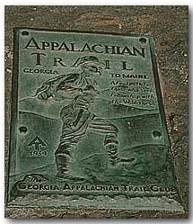
Image: One of the plaques on Springer Mountain Marking the beginning or end of the Appalachian Trail
Springer Mountain marks either the beginning or the end of a hiker’s journey on the Appalachian Trail. It is the southern most point on the trail; though the Appalachian Mountain Chain extends from Cape Gaspe, Canada to Alabama, in the US. Springer Mountain is known best as the southern terminus of the world famous Appalachian Trail which, because of the AT, makes this otherwise unremarkable mountain a world destination.
How Springer Mountain came by its name is unsure. It is thought to be named in honor of William G. Springer, an early settler appointed in 1833 by Governor Lumpkin to implement legislation that would improve conditions for the Indians. Another possibility is that Springer was named for the first Presbyterian minister to be ordained in Georgia, John Springer, ordained in 1790. According to Victoria Logue, “As recent as 1959, some residents of Gilmer County were still calling Springer, Penitentiary Mountain. According to the Gilmer County Historical Society, the name was officially changed by the Georgia Appalachian Trail Club. Nobody seems to know why it was called Penitentiary--the origin of the name having been lost over time."
When north to south hikers have reached the AT terminus they still have an additional 8-mile hike.
Beginning the hike south to north there are two trails that will take you up Springer Mountain where the two plaques reside, that marks the beginning (or end) of the AT. Amicalola Falls State Park (Amicalola is a Cherokee word meaning "tumbling waters) is one popular trailhead and at the visitor center you can weigh your backpack out front and continue to the back of the building where the East Ridge Trail (Springer/AT approach trail) begins.
Most who start the hike, from Amicalola Falls State Park stay overnight in the Black Gap shelter a mile south of Springer Mountain. However, there is an excellent shelter with privy shortly after the start of the AT.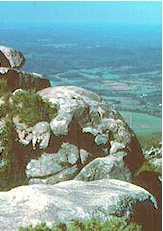
Image right: View from the Appalachian Trail on Springer Mountain
There are some exceptional views from the top of Springer Mountain, especially to the west. Approximately an eighth of a mile north of the start is the Springer Mountain Shelter with a dependable spring. A few steps north of that the Benton MacKaye parts the AT to the right, following the original route of the AT in this area. From here the trail slopes down to Forest Service Road 42 at Big Stamp Gap, where many people park and walk to the top of Springer Mountain. Passed the parking area the trail is level, and the Benton MacKaye rejoins the AT. At mile 2.5 is the Stover Creek Shelter, to the left down an old logging road. The AT follows this logging road to the right as it parallels Stover Creek for the next mile or so.
Technorati Tags: [Blue Ridge][Springer Mountain][Appalachian Mountain Chain][Appalachian Trail][Cape Gaspe, Canada][Alabama][Georgia][Hiking]
posted by D L Ennis @ 11:17 AM
![]()


1 Comments:
At Monday, 10 April, 2006, Karen said…
If you have done the Springer Mountain hike, you were within a few miles of where I grew up and went to high school. If you drove up Georgia route 52, you passed the house where I lived. Now you know my Appalachian roots...
Post a Comment
<< Home