The Photography of D L Ennis, and more!


Tuesday, January 31, 2006

Uncertainty over Future of Aldie Mill


Loudoun County Officials and the Virginia Outdoors Foundation (VOF) are at odds over the terms of Loudoun County taking ownership of the historic Aldie Mill in Aldie, Virginia.

The Virginia Outdoors Foundation, which has owned the mill since 1981, has been in negotiation with the county for more than two years with a view to transferring ownership to Loudoun. The county, in turn, has arranged to lease the building to the Virginia Organic Consumers and Producers Association, owned by Upperville businesswoman and philanthropist Sandy Lerner.

The county was expecting a deed similar to the 1981 transfer to VOF from the mill’s then owners, the Douglass family. That document is drawn up in very general terms and does not refer to specific restoration requirements or provide any protection clauses for the mill, which is listed on the Virginia and National Registers of Historic Places and is located in the county’s Aldie Historic District.

However, what the county got from the Virginia Attorney General’s Office late last November was a shock, officials said, noting the 2005 draft deed contained a number of “restrictions” and requirements that would require Department of Historic Resources oversight.
The deed clauses that appear to have incurred the county’s objection concern preservation and maintenance, all of which must be state approved.
Loudoun County officials voted unanimously last month to reject the deed as proposed; County officials feel that the VOF framework of the agreement would be to onerous for the county. But, the VOF, the state attorney general’s office and the Virginia Department of Historic Resources say “…they have a fiduciary duty to the commonwealth and a number of private donors who contributed to the restoration of the building to a working mill to ensure that it is protected in perpetuity.”

It’s easy to see both sides of the argument as reasonable actually. To sum it up, the County feels that they can’t be expected, or afford, to sign a blank check to ensure the protection and continued maintenance and upkeep for future generations to enjoy. On the other hand, the VOF maintains that the policies are meant to ensure good stewardship in keeping with the donor’s wishes and intent and as a conservation organization; VOF should not let the property go without providing for its future protection.

You can read the article that the above excerpts were taken from here in Leesburg Today Online.


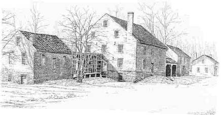
The Aldie Mill Today

Gristmills once dotted the landscape of Virginia and rural America, but most of them have now vanished or stand abandoned as silent witnesses of the past. At Aldie Mill, a working mill owned and operated by the Virginia Outdoors Foundation, the unique heritage of water-powered gristmills is remembered and preserved. The restored Aldie Mill, an imposing four-story brick structure with tandem metal waterwheels, offers visitors and students a glimpse of how life was lived in the rural South during a time when the Mill served as a vital center of the community.

Demonstration grinding and tours of the site take place on weekend afternoons. Historic research, archaeological investigations, historic preservation and restoration work, and educational programs form the core of the Mill’s mission.

An annual Art Show & Sale, held every June, is a major community event involving artists from around the region and as far away as Richmond and New York. Aldie Mill also participates in the Aldie Harvest Festival every October, when arts and crafts displays fill the village and crowds of spectators come to Aldie for a day of fun and celebration. The Mill is open from late April to late October: Saturdays, 12 – 5 P.M., and Sundays, 1 – 5 P.M. Special tours can be arranged by appointment during the week. Aldie Mill is located on U.S. Route 50, 1 mile west of the intersection of U.S. Routes 50 and 15.

Aldie Mill Historic Site
39401 John Mosby Highway,
P.O. Box 322
Aldie, Virginia 20105

You can read more about the Aldie Mill here including the history of the Mill.


Technorati Tags:

Monday, January 30, 2006

Whitewater Falls


Whitewater's spectacular 411-foot plunge. Photo by JP Bode, over at WNCHiker. Check him out!


This is one of my favorite waterfalls of all that I have visited, over the years, anywhere in the US. It is absolutely beautiful!
Upper Whitewater Falls is the highest waterfall east of the Rockies. The falls plunge an amazing 411 feet! South Carolina's Lower Whitewater Falls drops another 400 feet. Because of the escarpment's difficult access and rugged terrain, much of the area receives few visitors and has remained wild and undeveloped over the years. In the cool, moist shade of steep slopes and rock cliffs, wildflowers and salamanders abound. This wild land is also a perfect haven for a rich array of ferns, mosses, and fungi. Enjoy the beauty of berries and blooms throughout the seasons.

Hours: Dawn until dusk, year-round.
Picnic tables: Yes
Restrooms: Yes
Fee: $2 for vehicles with seven passengers or less; $1 per person for more than seven people traveling together in a vehicle. Annual pass available for $15; One-day or season permits are also valid at Whiteside Mountain and at Dry Falls.
Camping: No
Where to find the best views: For an excellent view of Whitewater Falls, follow the paved walkway to the upper overlook. The walkway begins at the end of the parking lot and is accessible to wheelchairs. A lower overlook is located at the bottom of 154 wooden steps. More energetic hikers can continue down the half-mile spur trail that drops 600 feet in elevation to the Whitewater River and Foothills Trail. With the exception of the two overlooks near the top, no other views of the falls are offered.The best views of the falls are from the two overlooks. However, some people venture off the trail to try for better views. Tragically, several of these people fell to their deaths or suffered serious injuries at Whitewater Falls. Please stay on the trails.

The Foothills Trail stretches along the Blue Ridge Escarpment in North Carolina and South Carolina for 85 miles. After descending the spur trail, hikers may head east on the Foothills Trail to South Carolina, the Lower Whitewater Falls, and other eastward points. The majority of trail maintenance is provided by volunteers with the Foothills Trail Conference, whose board includes representatives of managing agencies and landowners. The Highlands Ranger district of the Nantahala National Forest manages a 4.5-mile segment of the Foothills Trail from the NC-SC State line east of Whitewater Falls to the NC-SC State line, west of the falls.

How to Get There

From Cashiers: Drive south on NC 107 for 9.3 miles. Shortly after crossing the State line, turn left at the sign for Whitewater Falls. Continue 2.3 miles to the intersection with SC 130, which becomes NC 281 at the North Carolina State line. Just beyond this point is a sign for the entrance to Whitewater Falls.

From Brevard: Drive west on U.S. 64. At Sapphire, turn left on NC 281 and go south to the Whitewater Falls entrance.

From South Carolina: Drive north on SC 130, which becomes NC 281. The Whitewater Falls entrance is on the right after driving into North Carolina.

From Walhalla, SC: Use SC 107 and cross over to SC 130 and NC 281.

From Asheville: Take 240-West to I26-West. Go to the Asheville Airport/Brevard Exit (exit 9) and take a right onto U.S. 64. Drive to Brevard and follow above directions.


Technorati Tags:

Looting at Big South Fork National River and Recreation Area


Image: Rock Shelters or Rock Houses as they are sometimes called were at different times used as shelter by Native Americans, as homes, schools or animal pens by early settlers and even as sites for moonshine stills by later entrepreneurs.

The Big South Fork National River and Recreation Area is located in north central Tennessee and southeastern Kentucky in some of the most rugged terrain of the Cumberland Plateau. Big South Fork encompasses approximately 125,000 acres of both rugged forested gorge and adjacent forested plateaus. State and federal lands share the north and western boundary, offering a variety of habitats for both plants and animals. Within the Area many pristine streams, both in Tennessee and Kentucky flow into the free-flowing Big South Fork of the Cumberland River. Deep gorges carved by eons of erosion have created impressive cliffs and arches throughout the National Area.


To the trained eyes of the archaeological team, evidence of their occupation was everywhere. Scattered on the ground were the remains of spear and arrow points, a baseball-size rock the prehistoric hunters and gatherers had used as a hammer stone, and pieces of flint used to scrape animal hides.

As Tom Des Jean, an archaeologist for the Big South Fork National River and Recreation Area, explained, the team was picking through artifacts looters had left behind.

"Probably 40 percent of the rock shelters that are archaeological sites in this park have experienced looting from people looking for Native American relics," Des Jean said. "Most people don't comprehend the loss of information when you dig up one of these sites. They are an irreplaceable part of our American heritage."


While looting and gratuitous damage is executed in too many of our National parks across the country, perhaps no where is of greater importance than in the Big South Fork simply because of the latitude of archaeological sites, Native American artifacts, historical and cultural significance of the area.


Located on the Cumberland Plateau in Tennessee and Kentucky, the park contains 1,338 documented archaeological sites -- more than in any other national park in the Southeast. By comparison, the Great Smoky Mountains National Park, which is almost five times bigger than Big South Fork, includes 450 known archaeological sites.

What are these looters getting for their trouble? Well if caught this is what they get:


Archaeological resources on public lands are protected under federal law. In the summer of 2004, backcountry rangers with the Big South Fork caught two men red-handed while they were digging and removing artifacts from one of the park's rock shelters. The men, both from Pulaski County, were arrested and fined $3,198.09 under the Archaeological Resources Protection Act.

"All they got was a few points worth $5 or $6 apiece," Des Jean said. "Their entire take was only $120."

And, you can see what they would have made off with if they hadn’t got caught; $120.00 total.

When you go into our National Parks, National Forest and other public lands PLEASE, leave nothing but footprints and take nothing but pictures and wonderful memories!

You can read the article that the excerpts quoted above were taken from here.


Technorati Tags:

Sunday, January 29, 2006

National Park Service; Changes in Management Policies


In Asheville, on Monday January 23, more than a dozen people questioned Blue Ridge Parkway Superintendent Phil Francis about proposed policy changes that could affect the parkway, Smokies, and Carl Sandburg Home National Historic Site.

“What I worry about is the use of public lands for short-term exploitation at the expense of longer term resource protection and conservation,” said Walter Burnett of Whittier.


Some critics worry the changes in the language of the policy shift the park service focus from resource protection to recreation and visitor use.

“What these management policy changes appear to do is to provide greater wiggle room for park managers to allow the kind of uses that have historically been recognized as having negative impacts on the park,” said Greg Kidd with the National Parks Conservation Association.


“Greater wiggle room” has already been provided to those who manage our National Forest apparently. Where I live, my land borders the George Washington National Forest, and hunting out of season, cutting of standing timber for fire wood, desecration of old home sites, and the illegal use of OHV’s (Off Highway Vehicles) happens seven days a week. It doesn’t matter how often that you report these abuses; nothing is ever done about it.

Can we afford to let the same things happen to our National Parks?


You can read the article that I have taken the above excerpts from here.

There is more interesting reading on the lax rules and damage being done to our National Forests here and here. Not that these lax rules are being enforced or anything!


Technorati Tags:

Blue Ridge Parkway Trails: Near rt. 60


Image: by D L Ennis, taken near the entrance of the Whetstone Ridge Trail.

These trails are a short drive from Lexington, Buena Vista and the Rockbridge area, Amherst and Lynchburg.

· Whetstone Ridge Trail - Milepost 29 on the Parkway. A 12 mile US Forest Service managed trail starting at Whetstone Ridge Visitor Center. Trail runs directly along the spine of the ridge for 8 miles of breathtaking views. Moderate.

· Boston Knob - Milepost 38.8 on the Parkway. A leg stretching walk only .10 mile in length. Easy.

· Otter Creek - Milepost 63.1 on the Parkway. A pleasant 0.8 mile loop trail through the forest overlooking Otter Lake. Easy.

· Yankee Horse Trail - Milepost 34.4 on the Parkway. A short 0.2 mile walk to a small waterfall overlooking a reconstructed logging railroad from the early 1900's. Moderate.

· Indian Rocks - Milepost 47.5 on the Parkway. A 0.3 mile walk through the woods to spectacular rock formations. Good choice for children because of the short walk and rocks to climb on. Moderate.

· White Oak Flats - Milepost 55.2 on the Parkway. Length is 0.1 mile. Easy.

Enjoy and remember; leave nothing but footprints and take nothing but pictures and memories.


Technorati Tags:

Saturday, January 28, 2006

Alabama’s Cathedral Caverns


Image left: Goliath Believed to be the world's largest stalagmite column inside a commercial cave, standing 45 ft. tall and 243 ft. around. Estimates make this formation billions of years old.

Experience the beauty of the stalagmite formations with special lighting that further enhances their natural beauty, all with names that fit their shapes and size. The cavern will carry you 3,559 feet from the time you enter the cave until reaching the end of the tour.

Alabama's newest state park! The first thing you notice about Cathedral Caverns is the massive entrance. The huge opening measures 126 feet wide and 25 feet high. And it gets even better. Inside the cavern, you will find Big Rock Canyon, Mystery River and some of the most beautiful formations Mother Nature has ever created. Among them, you will see Stalagmite Mountain, The Frozen Waterfall and Goliath, a huge stalagmite column that reaches the ceiling of the cave some 45 feet above!


Image right: Frozen Water Falls


Effective January 1, 2006

January 2 - March 14
December 1 - 24
Saturday & Sunday:10:00 a.m.; 12:00 p.m.; 2:00 p.m.; 4:00 p.m.

Monday - Friday:Groups of 10 or more by appointment

March 15 - August 31
Daily:10:15 a.m.; 11:15 a.m.; 12:15 p.m.;
1:15 p.m.;2:15 p.m.; 3:15 p.m.; 4:00 p.m.

September 1 - November 30
December 26 - 31
Daily:10:00 a.m.; 12:00 p.m.; 2:00 p.m.; 4:00 p.m.

Closed New Year's Day, Thanksgiving Day, Christmas Day

Adults: $8.00
Children under 12 years of age: $5.00
Children under 5 years of age: FREE
School Groups: Students, Teachers, and Chaperons $5.00 each
Groups of 25 or more $6.00 per person with reservation.

Cathedral Caverns
637 Cave Rd.
Woodville, AL 35776
256-728-8193
256-728-8193 (fax)
ccaverns@nehp.net

Note: Access to the cave is available only with a tour guide for your safety and convenience.

Click here to see additional images of the caverns, including some amazing images of parts of the caverns not open to the public; in the Crystal Room and the Second Forest.


Technorati Tags:

“The Old City Cemetery” A Painful Legacy


When you first drive in to the Lynchburg, Virginia’s, Old City Cemetery you get the feeling that you have entered just another old graveyard. However, once you park and begin to explore you soon find out that this “old cemetery” is not just any old cemetery. Instead, it is engulfed in history, the history of a sad and painful time in American history; the Civil War era.

The Station House Museum tells the story of the railroad during the era and its importance to the areas economy, life and death of Lynchburg residents and the rails importance to the soldiers of WW 1 (1917-1919) that passed through Lynchburg on their way to the coast and the war. These soldiers dubbed Lynchburg, “Lunchburg”, because of the hospitality of the Red Cross Canteen service which provided these soldiers with food and drink on their stop in Lynchburg.

The three major railroads that ran through Lynchburg in1864, turned the city in to a regional hub of industry and tobacco and made it one of the wealthiest cities per capita in the United States. During the Civil War, the railroads made Lynchburg the second largest hospital center in Virginia.

The Hearse House tells another part of a devastating and sad time. Across the cobble stone road, resting on a hill is the Pest House Medical Museum, one look inside reveals the crudity of medicine during the time. One can only imagine the screams of pain of a recent amputee and impending infection which followed. You can sense the overwhelming adversity endured by not only the Pest House patients but of Dr. Terrell, Rev. Louis and the missionaries that ministered to the “spiritual and medical needs of patients. During the Smallpox epidemic of 1862-1864, it is said that no one but these brave and hardy souls were the only ones that would go near the place.

Entering the Confederate Cemetery and seeing the rows of markers, over 2200, a good number of which are unmarked, you can’t help but feel how painful it was for the families of these lost soldiers: not only eventually knowing that their loved one had likely died, but where they had died, and where there remains rested as well as never having any real closure.

In the Confederate Cemetery, soldiers from fourteen states rest there, from Virginia to Florida, west to Texas. One-hundred eighty-seven Union soldiers (prisoners) died in Lynchburg Hospitals and were buried in the cemetery until 1866 when they were removed by the Federal Government and ordered to a Federal Cemetery near Norfolk Virginia.

The gardens, selected trees and the old brick walls, among other things lend a rejuvenation of life that helps, if only briefly, relieve some of the pain of America’s reflective history.


Technorati Tags:

Floyd Country Store Presents "Live from the Crooked Road"


Mark your calendar: On February 11th at 7:30 pm there will be a concert at the FloydCountry Store in Floyd, VA. It's called "Live from the Crooked Road"and will feature the following artists:

No Speed Limit

Wayne Henderson - National Heritage Award Recipient

Montana Young

Anderson Strickland

Admission is $8, and the proceeds from the concert will benefit musicians with Scotland Tour Expenses.

Thanks to Kristin at the Blue Ridge Writer for sending me the info on this!


Technorati Tags:

Cunningham Falls State Park


In the Blue Ridge Mountains of Maryland you’ll find Cunningham Falls State Park, located in the Catoctin Mountains, is known for its history and scenic beauty, as well as its 78-foot cascading waterfall. The Falls are located one half mile from the lake in the Houck Area via the Falls Trail.

Before the first Europeans arrived, many small Native American tribes farmed, hunted and fished the area. Tradition says the name Catoctin came from the tribe, the Kittoctons, who once lived at the foot of the mountains near the Potomac River. By the time the settlers began to arrive in the Monocacy River Valley, Native Americans were seldom seen.
Early settlers used timber from the forests to make charcoal to fuel the Catoctin Iron Furnace. Too many years of clear-cutting and unscientific farming practices contributed to the overuse and destruction of the land.

In 1954, the area was divided into two parks, divided by Maryland Route 77. The northern 5,000 acres is now Catoctin Mountain Park, a unit of the National Park Service. The remaining 5,000 acre parcel was named Cunningham Falls State Park.
There are two main developed areas in the park, the William Houck Area and the Manor Area. Check out a map of the area.


To learn more about Cunningham Falls State Park click here.


Technorati Tags:

Hunter's Raid Civil War Trail


Click the map of the 'Hunter's Raid Civil War Trail' for a larger view.

On May 11, 1864, 257 Virginia Military Institute cadets marched 84 miles to New Market, VA to take part in the Battle of New Market. Their valiant efforts cost a dear price as 10 cadets lost their lives and another 45 were wounded. The corps, however, was instrumental in turning the battle to defeat Union General David Hunter’s regiment. In retaliation, General Hunter brought forces 18,000 strong into Lexington, home of VMI. The Institute was considered a legitimate military target, as it was both an arsenal and a military training school. On June 12, Hunter ordered VMI burned.

On May 26, 1864, Union Gen. David Hunter marched south from Cedar Creek near Winchester to drive out Confederate forces, lay waste to the Shenandoah Valley, and destroy the railroads at Lynchburg. His raid was part of Gen. Ulysses S. Grant's strategy to attack Confederates simultaneously throughout Virginia. After defeating Gen. William E. “Grumble” Jones at Piedmont on June 5, Hunter marched to Lexington, burned Virginia Military Institute, and headed to Lynchburg. There, on June 17–18, Gen. Jubal A. Early repulsed Hunter and pursued him to West Virginia. Early then turned north in July to threaten Washington.


Now you can drive at your leisure and visit all of the historic places The Hunter’s Raid Civil War Trail will take you.

The Hunter’s Raid Civil War Trail is a scenic driving tour of Union General David Hunter’s 1864 raid through the Shenandoah Valley. Detailed trail markers may be found along the way.

Technorati Tags:

Friday, January 27, 2006

2006 Appalachian Mountain Photography Competition


This from the Appalachian State University Alumni website.
BOONE—Appalachian State University’s Outdoor Programs and the Blue Ridge Parkway Foundation are sponsoring the third annual Appalachian Mountain Photography Competition. The competition is open to amateur and professional photographers whose work has captured the unique people, places and pursuits that characterize the Southern Appalachians.

Categories for entries are: Culture, Environment, Adventure, Landscape, Blue Ridge Parkway, and Flora/Fauna. Prize packages and $1,000 in cash prizes will be awarded. The prizes are made possible in part by the contributions of the Blue Ridge Parkway Foundation.

Entries must be submitted no later than 5 p.m. Feb. 27. For entry procedures and more information, visit www.op.appstate.edu or www.brpfoundation.org.All winning and special mention photographs will be displayed in Appalachian’s Turchin Center for the Visual Arts March 25 through April 29. A panel of professional photographers will judge all entries and winning photographers will be notified on March 3.

Image from: The Blue Ridge Parkway Foundation

Technorati Tags:

Repairs and Improvements Planed at Bent Creek


Click map for a larger view.


Press Release: NFSNC, Released January 24, 2006

USDA Forest Service Plans Repairs and Improvements at Bent Creek
ASHEVILLE…..The Forest Service announced today a number of planned actions to reduce erosion and sedimentation and improve road and trail conditions in the Bent Creek Experimental Forest, a Southern Research Station facility located on the Pisgah National Forest.
According to Randy Burgess, Pisgah District Ranger, “Heavy rainfall during last year’s Hurricanes Ivan and Frances resulted in widespread erosion and sediment getting into Bent Creek. The floodwaters carried large amounts of sediment into Lake Powhatan, which is one of our most popular fishing and swimming areas on the Forest. We plan to take a number of steps to repair the damage and reduce the long term risk of future sediment adversely affecting Bent Creek and Lake Powhatan. While these actions are designed to protect the water quality and fisheries of Bent Creek and Lake Powhatan, they will also make the Bent Creek roads and trails better and safer.”

The Forest Service is currently looking at options for dredging a portion of Lake Powhatan to remove the sediment that was deposited there. During the dredging later this year Lake Powhatan will likely be closed to swimming or fishing for several months.
The Forest Service is also taking a number of steps to reduce the amount of sediment entering Bent Creek and Lake Powhatan. A variety of techniques will be used to divert water off the roads and trails and away from streams. The following actions should be completed over the winter and spring of 2006:

Repair and improve Bent Creek Road along with seven other gated Forest Service roads (includes replacing culverts and installing new ones),
Repair several designated trails used for mountain biking (includes five minor re-routes),
Close out and rehabilitate a number of unauthorized user-created trails,
Relocate and improve one user-created trail that connects the North Boundary Trail with the Sidehill Trail and designating it as part of the trail system to provide an additional trail loop,
Stabilize eroded stream banks to reduce sediment entering Bent Creek.

The Forest Service has also improved several visitor facilities at Bent Creek, including new trailhead parking facilities and vault toilets at Rice Pinnacle, Hardtimes, and Ledford Branch. Last spring new water lines were installed at Lake Powhatan Campground and a number of campsites will be renovated this year.

In addition, archeological research is planned on two 19th century mill sites that were damaged by heavy rainfall following the hurricanes. The Forest Service also plans to refurbish a damaged stone sluiceway and spring box constructed by the Civilian Conservation Corps in the 1930’s.

Burgess added that “the Forest Service will make every effort to time these repairs to minimize temporary impacts to the recreational users at Bent Creek. In addition, the Forest Service is employing experienced trail contractors in order to make sure the repairs are done in a way that maintains the recreational experience at Bent Creek without disturbing important research studies that are underway.”

The Bent Creek Experimental Forest, located on the Pisgah National Forest, is one 28 Southern Research Station research facilities and one of the oldest research and demonstration forests in the country. Researchers and science delivery professionals at Bent Creek work closely with Pisgah National Forest employees to continue Bent Creek primary mission of research and demonstration of Southern Appalachian forest ecology and management while maintaining visitor services. Previously planned plot installations being done for research studies will be finishing up this spring and summer. More information about Bent Creek Experimental Forest can be found here.

For more information, contact any of the following:
Randy Burgess; Pisgah District Ranger 828-877-3265 Susan Matthews; Bent Creek Experimental Forest Outreach Coordinator 828-667-5261 ext 113 Steve Hendricks; National Forests in North Carolina (NFsNC) Trails Coordinator 828-257-4873 Brady Dodd; NFsNC Forest Hydrologist 828-257-4214.

Technorati Tags:

Thursday, January 26, 2006

U S Forest Service agrees to protect old growth forest


More than 700 acres in the Nantahala National Forest near Highlands — some if it never before logged — will be protected following a compromise reached between the U.S. Forest Service and environmental groups protesting a proposed logging operation.

Environmental groups contended the U.S. Forest Service neglected to recognize and protect significant stands of old growth forest in an area slated for selective logging.
“This error might have gone unnoticed, leaving the huge, old trees open to logging, if not for the careful forest watch role played by the conservation groups and their members,” stated a press release issued by a coalition of five local environmental groups that opposed the logging operation.


Read the rest of the story here.


Image right: HikeWNC, View from the summit of Whiteside Mountain overlooking the Nantahala National Forest.

Nantahala (nan-ta-hala) is an Indian name meaning "Land of the Noonday Sun." This name is most appropriate as the sun only reaches the floor of the deep gorges and valleys when directly overhead at midday.

The Spanish Conquistador, Hernando DeSoto, explored the area in 1540 and in 1920 the Forest was established. It is the largest of the four national forests in North Carolina lying in the mountains and valleys of western North Carolina with elevations as high as 5,800 feet at Lone Bald in Jackson County, to a low 1,200 feet in Cherokee County along the Tusquitee River and is the home of many western NC waterfalls.


Technorati Tags:

Wednesday, January 25, 2006

Grandfather Mountain Blows New Record


Image: Rime Ice
When clouds freeze on the trees, it forms a frozen phenomenon called rime ice. When the mountain is covered with rime ice, Grandfather takes on a truly fairy-tale atmosphere.

Today, winds of at least 200 miles-per-hour were recorded on Grandfather Mountain.

The wind speed breaks the previous record of 195-point-five miles per hour set almost nine years ago.

The previous record was set April 18th, 1997.

Grandfather Mountain officials say the upper limit on Grandfather's anemometer is 200 miles per hour, but the needle on the gauge actually went beyond its limit.

The wind blew out three double-strength steel-wire-reinforced windows at the mountain's visitor center and upended a 300-pound boulder that was cemented into the parking area.

Source: WWAY-TV Wilmington NC


Technorati Tags:

The Mayapple Springs to Mind


Image: Mayapple (Podophyllum peltatum) by D L Ennis

Today, here in the Blue Ridge Mountains of Virginia, there is a cold wind howling with intermittent snow showers and I have to admit, I'm thinking of Spring. When I think of Spring on a day like this it brings to mind the Mayapple which can be found growing throughout the Blue Ridge.

Podophyllum peltatum is most commonly known as the mayapple, but in various regions it is also known as Devil's apple, hog apple, Indian apple, umbrella plant, wild lemon, and American mandrake (though it should not be confused with true mandrake, Mandragora officinarum, an unrelated Old World plant whose roots have been used throughout history for medicines and potions.)

The Mayapple is a perennial plant in the barberry family (Berberidaceae) which is found in woodlands in Canada and the Eastern U.S. (Eastern being East of Oklahoma). These plants reach 6-18 inches in height and grow in patches. Each plant has a single stalk topped with one or two broad, deeply divided leaves that vaguely resemble umbrellas. The two-leaved plants normally produce a single, small white flower (usually in May, thus the name) from the fork in the stem. The flower develops into a pulpy, lemon-yellow berry which ripens in late summer and is the only part of the plant that isn't poisonous (however, the berries should only be eaten in moderation, if at all.)

The plant's long, thin rhizome (a horizontal underground stem from which the roots grow) is the most poisonous part, but also the most useful because it contains high concentrations of the compounds podophyllotoxin and alpha and beta peltatin, all of which have anticancer properties. Two closely-related Asian species, P. emodi and P. pleianthum, contain these active ingredients in lesser quantities as well as an alkaloid called berberine which can be used to treat fevers (especially malaria) and as an antibiotic.

The rhizomes have a long history as a medicine among Native North American tribes. They used to gather the rhizomes in the autumn and dry them and grind them to a powder. They would eat or drink a brew of the powder as a laxative or to get rid of intestinal worms. The powder was also used as a poultice to treat warts and tumorous growths on the skin.

Currently, extracts of the plant are used in topical medications for genital warts and some skin cancers. In China and Japan, the rhizomes of P. pleianthum are used to make a compound called Hakkakuren, which is used to treat snakebites and tumors of the genitals.

The purgative action of Mayapple rhizome powder is very strong, and the compounds in it are much too toxic to attempt self-medication with this plant.

The FDA rates the use of this plant as "unsafe."


Technorati Tags:

Turkeybeard Blooms in the Shenandoah National Park


Image by, Norm Bourg

A rare patch of Turkeybeard or mountain asphodel (Xerophyllum asphodeloides) was found blooming on May 17, 2005 in the Shenandoah National Park at the bottom reaches of the Wildcat Ridge Trail. This patch is in its second year of blooming after a fire burned in the area 3 years ago.

Very few turkeybeards bloom in a given year. But the forest floors of two Virginia sites, George Washington National Forest and Shenandoah National Park, are covered with more than 25,000 of the plants. They have produced thousands of pompom-like blossoms of about 200 small flowers atop stalks 1.5 meters (4.5 feet) high. At least one impressive plant produced 27 stalks.

It is a state-listed endangered or vulnerable species in portions of its Appalachian range and is included in the U.S. Center for Plant Conservation's National Collection of Endangered Plants.

See this July 1, 2002 National Geographic story about this unusual event.


Technorati Tags:

Tuesday, January 24, 2006

Strap on the Skis: There's Snow in the North Carolina Hills


Cold weather makes a lot of otherwise normal people do some strange things, such as strapping narrow boards to their feet so they can slide very fast down mountains. Fortunately for them, North Carolina has a lot of places that cater to their breed.

In the NC high country, there are slopes that can handle beginners and families, as well as slopes for expert skiers and snowboarders; those who perfer to plummet rapidly downhill. Let’s hit the slopes to help you find the best fit.

Snowtubing is a relatively new addition to North Carolina’s winter sports menu. Cataloochee, Hawksnest, Scaly Mountain, Sugar Mountain and Wolf Laurel feature runs guaranteed to elicit squeals from snowtubers of all ages.

Appalachian Ski Mountain and Ski Beech each offer ice skating, too. And, right next door to the City Hall in the Town of Beech Mountain is a free public sledding area. More adventurous sledders also may find spots along the Blue Ridge Parkway.

Snowboarding has rapidly gained popularity on the North Carolina slopes. There are terrain parks at Hawksnest, Appalachian Ski Mountain, Sugar Mountain and Ski Beech for the audacious winter sports aficionado. Snowboarders also are welcome at Cataloochee, Sapphire Valley and Wolf Laurel.

Appalachian, known for its French-Swiss Ski College, turns outs students equipped to take on its entry level slopes like the Candied Apple, or tough runs like the Hard Core.

Cataloochee has 10 slopes, 25 percent aimed at beginners, 50 percent at the intermediate level and 25 percent for advanced to expert. Hawksnest has 12 slopes, 20 percent for beginners and 40 percent each for intermediate and advanced. Ski Sapphire has three runs, one for each level of expertise. Ski Beech, the highest ski resort in the eastern United States at 5,506 feet above sea level, has 15 slopes and 10 lifts.

Sugar Mountain has a 1,200 foot vertical drop, 20 trails and eight lifts spread over a 115 acre site. Some of the expert trails on the upper mountain have a 60 percent pitch. Wolf Laurel has 65 acres of skiing terrain, two new beginner slopes, a new double chairlift and a new magic carpet lift.

After your day on the slopes, if you aren’t too sore, there are plenty of dining, dancing and partying opportunities, too. From the Boone Saloon to Woodlands Barbecue and Pickin’ Parlor, you’ll find food and music that fits your tastes.

So, strap some wood to your feet and slide on over to North Carolina this season.

For more information on North Carolina ski areas go to the VisitNC.com ski report, GoSkiNC.com or call 1-800-VISIT NC.


Technorati Tags:

Maier Museum of Art: The 95th Annual Exhibition


Beginning Saturday, January 28 at the Maier Museum of Art in Lynchburg, Virginia “The 95th Annual Exhibition” will begin.

“Some Kind of Wonderful:” Featuring Recent Sculpture by James O. Clark and Tara Donovan.

These contemporary sculptors use commonplace materials—from toothpicks and plastic drinking straws to balloons and light fixtures—to create works of uncommon beauty that challenge the viewer to consider the nature of art and the process of art-making.

Museum hours are Tuesday-Sunday 1:00-5:00 p.m. and admission to the galleries is free.

Maier Museum of Art
Randolph-Macon Woman’s College
Lynchburg, Virginia
(434) 947-8136


Technorati Tags:

The Frontier Culture Museum


Here is something that you can do this weekend with the whole family; take them to the Frontier Culture Museum in Staunton, Virginia.

Take the kids on an educational outing and visit Europe and America's past at four different historic farms, moved from their country of origin, and reconstructed at the museum site, in Staunton, Virginia.

See the rare and minor breed animals, walk through the authentic gardens, help harvest period crops, watch a blacksmith at work, and visit with the farm interpreters to share a lesson of courage, heritage, and determination.

The Frontier Culture Museum has Special Guided Winter Tours, 10a.m. to 4p.m. 7 days a week.

Mention their website and receive 1/2 off your total ticket price...You can't beat that!

For more information call 540-332-7850


Technorati Tags:

Monday, January 23, 2006

A Mid-Winter’s Eve


On a mid winters eve, in the Blue Ridge Mountains of Virginia, I walk the gravel road that ends at my house, looking, listening, hearing and breathing in all that nature offers me. A dove in the distance coos as two lithely take to wing on a whistle from the tall burnt-gold grass that borders the road. Horses whinny as I pass the field where they feed, watching me like a dog guarding his food bowl.

On the northern wind blows a chill electrifying all living things, even I have more spring in my step. My puppies, frisky and playfully jumping and running; wrestling, and chewing on one-another's ear. They tumble as they trip over their oversized feet they have yet to grow into.

The mountains in the distant blue; the darkened wood adorned in evergreen, bejeweled with pools of sun adrift on the winds tide as day flows west.

As I turn right onto an adjoining road, the soiled gravel beneath my feet, harsh in contrast to all that my senses -now in full bloom- contemplate. A young whitetail doe, harmlessly feeding on grass along the edge of the coppice, flees into the wind crossing my path no more than twenty feet in front of me. Her eyes large and the deepest of brown, holding such beauty and wisdom of nature’s ways and instinct of survival handed down from antediluvian ancestors. I pause to admire her tracks along the roads edge, a ritual I have performed since childhood. I cannot help but to marvel at this sign of presence left by such an amazing animal, this gift given us, an endowment, as is all life on this extraordinary planet.

If man would slow down, take notice and ponder with reason, genuinely trying to see the singularity and splendor that all of life upon this breathing orb -that we call earth- offers. How much more congenial this world would be to live in.

Another hundred yards beyond this place there joins another road bordering the land of a friend forty years my senior, and I am not a young man. Charlie Floyd, a teller of tales both temperate and callous, has lived in these mountains for eighty-nine years and has more stories to tell than time to tell them. When time does permit, we sit beneath the tall pines over looking the hollow behind Charlie's small mobile home. There is a pond in this hollow filled with fish and loved by the local beavers and otters. Migrating ducks and geese make their presence known in spring and fall.

On this day, the pond - in spite of the brisk northern wind, is as smooth as silk but for an occasional ripple, as a wisp of wind steals down the ridge to intrude upon the serenity of the lakes surface. We sit in hush, there will be no story told today exclusive of the one unfolding before our eyes. One should pause and allow their senses to guide them through the oldest story told on this earth, a story understood by few--nature’s story.


Technorati Tags:

Georgia’s Blue Ridge Scenic Railway in Danger of Closing


Will the Blue Ridge Scenic Railway in Blue Ridge, Georgia shut down? According to this article on the Blue Ridge, GA, USA site they may have no choice but to close their operation.

This from the Blue Ridge, GA, USA blog:


Showdown at the Train Depot: a line has been drawn in the gravel between the Blue Ridge Scenic Railway and the city. Basically, in addition to raising the rent, the city wants to slap a $1 franchise fee on every ticket sold, and the railway has stated that if forced to pay the tax, it cannot afford to continue operations and has no choice but to shut down the railroad.


Blue Ridge Scenic Railway: Train History

The original main line was built to Murphy, North Carolina, which was reached in late 1886. The builders intended to continue until they reached Knoxville, Tennessee, but in 1887, the plans were changed as Knoxville and Blue Ridge were ultimately connected via a slightly different but much more exciting route via the Hiawassee River gorge.

At Talking Rock, Georgia, the line originally made an unusual 180-degreechange in direction through a very sharp horseshoe-shaped curve dubbed "the hook" by train crews. The curve was so sharp that crews claimed that if the conductor's cigar went out in the caboose, he had only to wait until the train got to the "hook", because he could merely lean out and get a light from the engineer.

Railroads played a significant role in the development of this area between the 1800's and the early 1900's, in that they determined the routes of local roads, saved an ailing mining industry, contributed to the growth of small towns as resort communities, and made it possible to log the last remaining virgin timber in the area.

In 1896, the Marietta & North Georgia Railroad was purchased and renamed the Atlanta, Knoxville & Northern, and in 1902 was sold yet again, taking on the new owner's name, the Louisville & Nashville Railroad, in 1905. Name changes came fast and furious after the 1960's; "Family Lines", "Seaboard System", and finally "CSX" in the 1980's. But by this time, passenger service had long since been terminated, with the line continuing on as a freight carrier.

In 1990, the line was put up for sale, and a group of local investors stepped in to preserve rail service into north Georgia. As a result, passenger trains are operating once again into the beautiful north Georgia Mountains.

Train Route:

The train route consists of a 26-mile round trip through historic Murphy Junction along the beautiful Toccoa River. This railroad was built over 100 years ago and is the only mainline railroad excursion service based in Georgia.


Each trip begins at the depot in Blue Ridge, Georgia and includes a stop in McCaysville which permits passengers to disembark and stretch their legs while exploring the downtown communities of McCaysville, Georgia and Copperhill, Tennessee. Each round trip takes approximately 3 1/2 hours.

The last passenger train to operate over this line was a one-time special trip that ran in the 1960's. The route was originally built as the narrow-gauge Marietta & North Georgia Railroad. Construction began in Marietta in 1877 and reached Blue Ridge in 1886.

BLUE RIDGE SCENIC RAILWAY
241 Depot StreetBlue Ridge, Georgia 30513
1-800-934-1898
1-706-632-9833
info@brscenic.com


Technorati Tags:

Appalachian Treasures: A National Campaign to End Mountaintop Removal


Image left: Coal seams lie deep below the surface therefore, 800 to 1,000 feet of the mountain top is removed, using dynamite, to recover the coal. The white dust at the bottom of this photo is the result of a dynamite explosion. Dennis Burke has stated that more pounds of explosives are used every four days in West Virginia than were used in the entire conflict in Afghanistan.

Launched by Appalachian Voices in March 2005, the Appalachian Treasures project is a national campaign to end the suffering and devastation that mountaintop removal coal mining has brought to the land and communities of Appalachia. Appalachian Voices has sent a full time field organizer out on the road, along with volunteers from Appalachia’s coalfields, and together they are traveling the country building a national network of people who will work together to end mountaintop removal.

At the heart of this effort is “Appalachian Treasures,” a multimedia presentation that features photos that capture the beauty of Appalachia along with disturbing shots of flattened moonscape mining sites, voice recordings of neighbors and friends recounting the daily struggles of life in the coalfields, and traditional music of Appalachia. This amazing presentation leaves a powerful, lasting impression of the beauty and the richness of the culture and heritage of Appalachia, as well as the needless devastation caused by mountaintop removal coal mining.


Image right: The debris, also known as overburden or spoil, is dumped into nearby valleys forever burying streams. These structures are unstable and likely to sink or shift.


3 ways you can help

1. Write a letter to your US Representative asking them to co-sponsor the Clean Water Protection Act, a bill that would protect coalfield communities. For more information and help writing your letter, click here.

2. Host a viewing of Appalachian Treasures. We would love to send you a free action kit that includes everything you need to host a viewing of “Appalachian Treasures” for your family and friends, church group, or civic organization. To request a kit, contact outreach@appvoices.org or 828-262-1500.

3. Make a donation to help keep the Appalachian Treasures project on the road by clicking here then click the “Support Us” tab above.

Image left: The coal is washed and treated before it is loaded on trains. The excess water left over from this process is called coal slurry or sludge and is stored in open ponds, or coal impoundments, like this one. Coal sludge is a mix of water, coal dust, clay and toxic chemicals such as arsenic mercury, lead, copper, and chromium. Coal impoundments are held in place by mining debris, making them very unstable. In 2000, a coal impoundment broke and spilled 250 million gallons of sludge that is more than 20 times the amount of oil lost by the Exxon Valdez


To learn more about mountaintop removal, please click here.

Appalachian Voices


Technorati Tags:

Sunday, January 22, 2006

The Blue Ridge Mountains & Shenandoah National Park


The oldest rocks in the Blue Ridge Mountains were created over a billion years ago as magma deep within the earth's crust moved upward. Over eons it cooled, fractured, and was joined by younger metamorphic rocks formed from sedimentary deposits. All were altered and eroded to shape today's granite peaks and sylvan hollows.

Around 10,000 years ago, but seconds in geologic time, the first traces of humans were recorded on the land that would become the park. Native Americans seasonally visited the area to hunt, to gather nuts and berries, and to find sources for and to make their stone tools.

Europeans first experienced the beauty of these mountains less than 300 years ago. First came hunters and trappers, and soon after 1750 the first settlers moved into the lower hollows near springs and streams. Over the next century and a half many hundreds of families built homesteads, mills and stores and planted orchards and crops. The mountains were logged and minerals were mined. Vacation resorts were established to allow guests to experience the mountain views, healthy water, and cool breezes. And American Society became urban, industrial, and yearned for special places for recreation and refuge.

In the early 20th century the first calls for National parks in the east were heard in the United States Congress. It would be two decades before Shenandoah National Park was authorized and another ten years before it was established. During that time President and Lou Henry Hoover established their Summer White House on the Rapidan River, the construction of Skyline Drive began, the Civilian Conservation Corps was established and moved into the park area, and over 450 families of mountain residents were relocated from the Blue Ridge.

With the establishment of the park in December 1935, the CCC began to build visitor facilities throughout the mountain, areas that were initially racially segregated. The core of the park's development was completed by the beginning of WWII, and to a great extent, the mountains were released to nature.


Click on the following links to read more about the, Shenandoah National Park Landscape and the CCC and, Shenandoah: Not Without the CCC.


Technorati Tags:

The Blue and Gray Trail


The Blue & Gray Trail pays tribute to some of the Civil War's most dramatic events. The thievery of Andrews' Raiders made famous in the Disney film "The Great Locomotive Chase" is noted in numerous railroad depots, historic markers, museums and events from Kennesaw to Tunnel Hill. Consider the site of one of the bloodiest Confederate victories where over 34,000 soldiers died - Chickamauga and Chattanooga was named the first National Military Park in 1890. Places like Missionary Ridge, Allatoona Pass and Pickett's Mill beckon you to remember more.

Along the Blue & Gray are historic Bed & Breakfasts, home cooked meals in local diners, and shops filled with Civil War memorabilia. Encounter life on the battlefield at many High Country reenactments and living history encampments. Recreational opportunities are endless in the land of the Blue & Gray.

Technorati Tags:

Kittatinny Ridge Conservation Project


The Kittatinny Ridge is the eastern edge of Pennsylvania’s Ridge and Valley Region.

The Kittatinny Ridge Project, led by Audubon Pennsylvania, is a collaborative effort of local, regional, and state organizations and agencies to focus public attention on the importance of the 185-mile long forested Ridge through Pennsylvania; and to promote conservation activities to protect the Ridge from further habitat loss, fragmentation, and inappropriate land use.

The Kittatinny Ridge (also known as Blue Mountain) is a long mountain ridge that winds 185 miles through eastern and central Pennsylvania, to the Maryland line. The Ridge is a globally-significant fall migration flyway used annually by tens of thousands of raptors and vultures and millions of songbirds, and has been designated by Audubon Pennsylvania, as the largest of the state’s “Important Bird Areas.” The many rock outcroppings along the ridge also make it an excellent place to watch migrating hawks, eagles and vultures. Hawk Mountain Sanctuary and Audubon’s HawkWatch at Waggoner’s Gap are located along the Ridge.

Kittatinny Ridge Conservation Corridor includes 160 miles of the Appalachian Trail; and serves as a vital link in the Appalachian Forest that stretches the length of the East, providing critical, high quality interior-forest habitat for dozens of species of songbirds, mammals, reptiles and amphibians. The Ridge also protects important drinking water supplies and stream habitat.


Technorati Tags:

The Georgia Mountain Parkway


Wildflowers in bloom on the Georgia Mountain Parkway

You will enjoy the breathtaking scenic beauty along the Georgia Mountain Parkway as you travel along the Zell Miller Parkway (Hwy 515/76) north from Atlanta’s Highway 575, which becomes Highway 515 to the North Georgia Mountains. The Georgia Mountain Parkway begins in Pickens County, gently climbing up Highway 515/76 through Gilmer, Fannin, Union, and into Towns Counties. The Georgia Mountain Parkway travels through the Southern Appalachian towns of Jasper, Talking Rock, Ellijay, Blue Ridge, McCaysville, Blairsville, Young Harris and Hiawassee.

Mountains of outdoor activities in the Chattahoochee National Forest await you along the highway such as: hiking, biking, whitewater rafting, tubing, fishing, and swimming. Along with scenic mountain views, the Georgia Mountain Parkway provides local flavor at a variety of dining establishments; shopping in quaint mountain craft, antique and art galleries & shops; accommodations at luxurious mountain resorts, cozy cabins or bed & breakfasts; and a plethora of country festivals featuring Appalachian culture through products such as apples, crafts, marble, and bluegrass and country music.


Technorati Tags:

Saturday, January 21, 2006

Moses H. Cone Park: Management Plan for Alternatives

Image: Cone Manor, Moses H. Cone Memorial Park-MT file Photo

Some trails at the Moses H. Cone Memorial Park may be allotted for bicycling under a plan currently being considered by the National Park Service.

The National Park Service is developing a management plan for alternatives that will guide the future development of the Moses H. Cone Memorial Park.

The study for the plan, launched in 2003, will guide the future of the park for the next 15 to 20 years.

Some of the topics that have been discussed include the addition of bicycling to all or a portion of the carriage trails. Bicycling is currently prohibited. Other topics include adding Americans With Disabilities Act-compliant facilities, expanding interpretative and historical storytelling events, and allowing camping on some areas of the property.

A newsletter, which will detail the draft alternatives and provide background information on the Cone management plan, will soon be mailed out.

It will also be posted on the Parkway Website www.nps.gov/blri. To receive the newsletter, contact Gary Johnson, Chief of Resource Planning, Blue Ridge Parkway, 199 Hemphill Knob Road, Asheville, N.C .28803; or email Gary_W_Johnson@nps.gov.

Cone Park was originally known as Flat Top Manor and was one of North Carolina’s premiere country estates.

It was built by textile magnate Moses H. Cone, who was known as “The Denim King.” The estate was completed at the turn of the 20th century and features remnant apple orchards, barns and the 23-room manor house.

The National Park Service acquired the estate in 1950 after Bertha Cone had donated it to a hospital, and it became part of the Blue Ridge Parkway.

The Moses H. Cone Park offers great outdoor recreation, even in the winter. The park, located between mileposts 292 and 295 on the Blue Ridge Parkway near Blowing Rock, contains more than 3,500 acres, with more than 25 miles of carriage, horse and hiking trails.

The carriage trail branches off to several other roads, including a one-mile walk to the Cones’ gravesite. An additional two-mile hike leads to Flat Top Tower, which provides a great scenic view of the park.

The trails also feature some historic elements as well as natural wooded areas. Signs warn that the soil may contain high levels of lead and arsenic, leftovers from the days when apple trees once covered many acres of land on the slope beneath the manor house.

Source: The Mountain Times

Technorati Tags:

Friday, January 20, 2006

The Scottish Tartans Museum


If you are of Scottish heritage or just curious about the Scots or just love museums, the next time you’re in the Smoky Mountains you’ve got to check out the “The Scottish Tartans Museum.”

A visit to the Scottish Tartans Museum and Gift Shop in the Smoky Mountains is a stroll through the history and culture of Scotland. Our 4800 square foot location on Main Street in downtown Franklin, NC, showcases a large Museum area as well as an expansive Gift Shop .

The Museum was founded by Scottish Tartans Society, formed in Scotland in 1963 to “study the origins, history and development of tartans.” The Society has two museums--one in Keith, Scotland, and one in Franklin, NC.

The Franklin Museum not only displays Scottish Tartans, but covers various aspects of the Scottish experience -- culture, history, dress, migration and military.

Visitors are invited to view their family tartan, connect with their clan, and learn about the history of Highland Dress.

Tartan research questions may be submitted to tartans@scottishtartans.org. We do our best to answer all enquiries in the order they are received. If you are interested in researching the recommended tartan for a particular surname, or would like a full color print out of your tartan, with thread count and other information, click here.


Franklin's 12 Annual Robert Burns Dinner

Come celebrate Robert Burns’ birthday with the Friends of the Scottish Tartans Museum on Saturday, January 28th, 2006 at Tartan Hall, Franklin Presbyterian church, beginning with the Parade of Tartans at 5:30 PM.

Robert Burns, a Scottish poet, was born 247 years ago. His songs and poems were written in the old dialect and his works served to preserve a piece of Scottish culture. For this reason, his memory is still honored each year around the world wherever Scots gather. This will be the 12th year that Franklin has held their Burns Night celebration.

Time is short. Get your tickets at Peoples Department Store, the Franklin Chamber of Commerce, or the Scottish Tartans Museum at $25.00 per person. This includes a Scottish Dinner with Haggis side-dish, traditional toasts, readings from Burns, door prizes, and entertainment. Scottish attire is encouraged but not required. However a desire for traditional Scottish food and fun is required.

Deadline for reservations: January 23rd, 2006. Phone the Museum at (828)524-7472 for more information.


To learn more about Robert Burns check out The Burns Encylcopedia.

The Scottish Tartans Museum
Hours of Operation
Monday through Saturday
10:00am to 5:00pm
CLOSED SUNDAYS

Museum Admission $1.00
Children 10 and under FREE

86 East Main St.
Franklin NC 29734
(828)524-7472
tartans@scottishtartans.org
http://www.scottishtartans.org/


Technorati Tags:

Thursday, January 19, 2006

Trails: A Public Meeting in Vinton

If you live in the Vinton area, in the Roanoke Valley of Virginia and are interested in hiking, you may want to attend a public meeting at the Charles Hill Senior Center on January 26 at 7pm. The meeting is being held to determine the level of interest, from the public, in a series of trails that could eventually be accessed from the Vinton area; trails along the parkway that could be tied in to existing paths like the Wolf Creek Greenway.


"We have worked with the Blue Ridge Parkway on the development of their trail plan," said Roanoke Valley Greenways Coordinator Liz Belcher last week, "because we wanted to be sure that the greenways would be allowed to connect to the Parkway trails." A variety of Blue Ridge Parkway trails from the Stewarts Knob overlook to US 220 have been cataloged and reviewed by various groups and consultants over the past few years, including horse trails that could be improved and open to other groups. "They always intended for it to be one long trail," said Belcher.

Eventually she said Mill Mountain trails should connect to paths along the parkway for a long continuous loop. Belcher described one trail that could now be taken from the Mill Mountain Greenway that winds up from downtown Roanoke along Prospect Road to one near the Discovery Center on Mill Mountain, to Yellow Mountain Road and the Chestnut Ridge Trail and then to a Park Service horse trail that winds up now at Rutrough Road. It could even go further if all of the loose ends are tied together, connecting it to another trail on the north side of the Roanoke River that heads to Stewarts Knob.


You can read the rest of the story
here.

Source:
The Vinton Messenger

Technorati Tags:

Asheville North Carolina, a Favorite Blue Ridge Mountain Resort Town


Press Release

RomanticAsheville.com, an online travel guide for Asheville and the surrounding Blue Ridge Mountains, has announced its Top 20 Romantic Outings for 2006 just in time for Valentine’s Day.

Asheville, NC (PRWEB) January 17, 2006 -- Are you looking for ideas for that perfect romantic getaway? RomanticAsheville.com, an online travel guide for Asheville and the surrounding Blue Ridge Mountains, has announced its Top 20 Romantic Outings for 2006 just in time for Valentine’s Day. They prove that romance doesn’t have to be expensive. The first eight outings are free, and the remaining ones are ranked by cost. See the complete list at RomanticAsheville.com. Here are the highlights:

1. Discover Lots of Art: Asheville is one of the top arts destinations in the country. Galleries and studios abound downtown and in the surrounding valleys. Watch the artists at work, and buy directly from them.

2. Cruise the Blue Ridge Parkway: Enjoy a leisurely drive to see nature's beauty while riding the crest of the mountains.

3. Watch a Sunset from a Mountaintop: Hike to the top of the Pinnacle at Craggy Gardens to watch the sunset (about 3/4 mile one-way). It’s a great spot to hold hands and kiss. West-facing overlooks on the Blue Ridge Parkway are perfect to watch a sunset from your car.

4. See the Smokies: For a romantic evening watching elk graze a short distance away, drive to the Cataloochee Valley section of the Great Smoky Mountains National Park.

5. Stroll through Gardens: Asheville is a garden city. Gardens with no admission fee include the Botanical Gardens at the University of North Carolina at Asheville and Richmond Hill Inn.

6. Picnic by a Waterfall: Take a picnic to Dupont State Forest and relax by one of three waterfalls. Ask your inn or hotel will prepare a picnic for you to take.

7. Explore Downtown Asheville: A creative way to see downtown is the Urban Trail, a self-guided walking tour of 30 sculptures that depict tidbits of local history.

8. Take a Hike: To really appreciate the natural splendor of the area, get out of the car and explore it by foot. There are trails for all fitness levels.

9. Soak in Hot Springs: Relax in natural hot mineral waters, hike the Appalachian Trail, stay in a romantic inn, or raft the French Broad.

10. Sunset on the Lake: Lake Lure is a beautiful lake surrounded by mountains. Their evening Champagne Cruise includes the tour of the lake and champagne at $49/couple.

11. Movie Date: See an independent or foreign film at the nostalgic Fine Arts Theatre downtown. An entire evening is less than $35, including tickets, popcorn and after movie coffee.

12. River Romance: Asheville is one of the best whitewater rafting towns in the U.S.! No experience is necessary. A half-day whitewater rafting trip is about $70/couple.

13. See a Show: There are many choices for theatre with Broadway musicals, comedies, modern dance, opera, and more. Tickets for professional shows average $60/couple.

14. All Aboard! Take a scenic train ride through the Nantahala Gorge. The Great Smoky Mountains Railroad has a variety of trips from $74/couple for half-day trip.

15. Spend a Day at Biltmore Estate: Explore the largest home in the country, see breathtaking landscapes, and tour the winery. General admission to the Estate is $90 per couple.

16. Most Romantic Dinner: For the most elegant evening of dining in Asheville, enjoy exquisite cuisine and fine wine at Gabrielle's at Richmond Hill Inn. The average check is $200 per couple.

17. Get Rejuvenated at The Spa: High stone walls, fireplaces and waterfalls accent a magical pool area at the acclaimed Spa at the famous Grove Park Inn. Treatments start about $250 per couple.

18. Get Married or Renew Your Vows: What a beautiful and romantic setting to celebrate your love and commitment!

19. Stay in a B&B: For a cozy romantic getaway, stay in one of the 50+ bed and breakfast inns in Asheville. A one-night stay is $150-$300 and includes a home-cooked breakfast.

20. Most Extravagant Overnight Stay: For the best in spacious luxury and comfort, reserve the William A.V. Cecil Suite at the Inn on Biltmore Estate at $1,400 per night.

For more details on these and other outings in the Asheville, North Carolina, area, see the complete list at RomanticAsheville.com. Start planning the perfect romantic getaway for any time of the year!


Technorati Tags: