Take a Hike on Cold Mountain
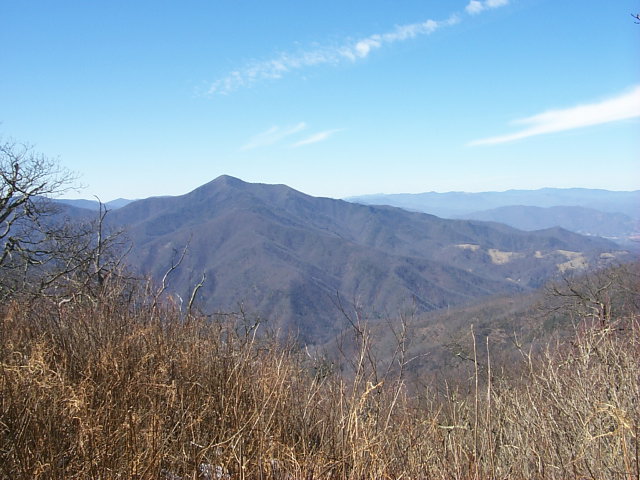
View of Cold Mountain, Shining Rock Wilderness Pisgah National Forest, North Carolina
On bookshelves around the world you will find Cold Mountain, a best-selling novel by Charles Frazier, whose lyrical prose makes you feel as if you have been to the summit. In the book, Inman, a wounded Confederate solider, leaves his hospital bed and heads home, on foot, to Cold Mountain.
An excerpt from Cold Mountain--
Inman can see west for scores of miles. Crests and scarp and crags stacked and grey to the long horizon. Catalucci, the Cherokee word was, meaning waves and mountains and fading roads, this day the waves could hardly be different from the raw winter sky that were barred and marbled and same-shades of gray only. The outlook stretched high and low like a great slab of streaked meat…it was to Cold Mountain he looked. He had achieved a vista of what for him was homeland.
You can find the real Cold Mountain in North Carolina’s Shining Rock Wilderness, which was originally part of the Cherokee Nation until white settlers with a land grant from the state began
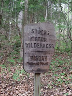 migrating here in 1796. At 6,030 feet, it is the tallest peak in the wilderness area. Located in the Pisgah National Forest, Cold Mountain hasn’t changed much since the Civil War in which the book is set.
At milepost 412.2 on the parkway, about 30 miles from Asheville, is where you’ll get your first glimpse of the peak. The best views of the mountain’s south face are from the Wagon Gap Road parking area. Thousands of travelers have had their pictures taken beside the Cold Mountain sign with the peak in the background.
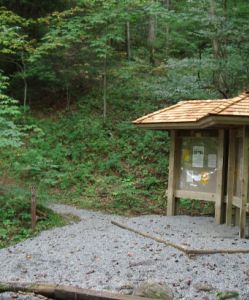
If you want an up-close and personal encounter with Cold Mountain, strap on your best hiking boots and pack and plenty of food and water for the invigorating 10.6-mile hike. Hikers gain 2,800 feet in altitude as they leave the Art Loeb trailhead at the Daniel Boone Scout Camp, heading for Cold Mountain’s summit. You’ll reach plummeting Sorrell Creek about two miles into the hike, a cold, clear mountain stream that passes by some excellent campsites.
The trail ascends to marvelously forested Shining Rock Ledge, past Deep Gap and up the final 1.5 miles to the summit. A tangle of rhododendron can make reaching the top a challenge. Only experienced hikers who have maps and a compass should try this hike since this is a wilderness area with no signs or trail markers.
There is no town named Cold Mountain here at the peak, only the wildlife, the forest, the coves and creeks that Frazier described so vividly in his novel. But on a clear, cool North Carolina autumn afternoon, what could be better than this place of quiet contemplation?
 Directions too reach the trailhead to the Cold Mountain summit, drive through the Scout Camp. It begins on the left, just past the last building.
Directions from Asheville via I-40: (Approximately 35 miles) Take I-40 West to exit 33. Turn left on Newfound Road toward Canton. Go 1.6 miles, turn left at the stoplight in front of the big paper plant. Go a short distance and turn right on Church Street. Follow 19/23 south through downtown and turn left onto NC Highway 110. Go 5.3 miles, and Highway 110 will turn into NC Highway 215. Continue for 5 miles. Turn left onto Little East Fork Road. Go 3.8 miles to the Scout Camp.
Directions from Asheville via the Blue Ridge Parkway: (Approximately 53 miles) At Milepost 423.2, take NC Highway 215 and go 13 miles north. Turn right onto Little East Fork Road. Go 3.8 miles to the Scout Camp.
There is also a Scenic Driving Loop
This approximately 85-mile loop drive combines the two below routes for the beginning of the Cold Mountain hiking trail. It is a beautiful, hilly, curvy drive through a very rural mountain area. Allow 3-4 hours. This section of the Blue Ridge Parkway is closed for much of the winter.
*Travel south on the Blue Ridge Parkway. For the best view of Cold Mountain, stop to hike Mt. Pisgah at Milepost 407. Continue south on the Blue Ridge Parkway, stopping at Cold Mountain overlook at Milepost 411.9. (See above "Best Places to View.")
*At Milepost 423.2, take NC Highway 215 north for 13 miles.
*If you want to drive an extra 8 miles roundtrip to go to the base of the hiking trail, turn right onto Little East Fork Road. Views of the mountain are limited.
*Continue for 5 miles. NC Highway 215 will turn into Highway 110. Continue 5.3 miles.
*In Canton, turn right onto Highway 19/23 north.
*Turn left onto Church Street, and right on Newfound Road.
*Go 1.6 miles to I-40 East to return to Asheville.
Technorati Tags: [Blue Ridge][Cold Mountain][Cherokee][Charles Frazier][North Carolina][Shining Rock Wilderness][Asheville][Pisgah National Forest][Blue Ridge Parkway][Wagon Gap Road][Hike][Trails][Sorrell Creek][Daniel Boone Scout Camp][rhododendron][Deep Gap]
posted by D L Ennis @ 10:13 AM
![]()


1 Comments:
At Monday, 12 June, 2006, Mark said…
I have never made this hike. I did try last fall but ended up getting there late and ran out of daylight. This will be the year for me to get there.
Post a Comment
<< Home