
Massachusetts’ Purgatory Chasm State Reservation
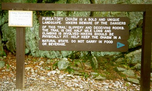
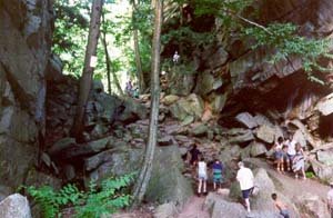
Purgatory Chasm State Reservation in Massachusetts, lays claim to a unique natural landmark. Purgatory Chasm runs for a quarter of a mile between granite walls rising as high as 70 feet. The park is popular with picnickers and rock-climbers alike and also has several hiking trails. The Chasm is believed to have its origin in the sudden release of dammed-up glacial melt-water near the end of the last Ice Age, approximately 14,000 years ago.
Purgatory Chasm is the result of weathering of closely-spaced, quartz filled, ‘joints’ that may mark edges of large rectangular-shaped boudins (cylinder like). Similar features in the same orientation, crop out along the northern Cliff Walk where conglomerate forms rectangular, sharp-ended boudins separated by quartz.
According to legend, Hobomoko (the Native American devil) carried a woman to Purgatory Chasm after she had murdered a white man. When the woman began to fight, Hobomoko hit her head against a boulder and attacked her with a tomahawk. The bowl-like depressions, supposedly, show where her head hit the boulder, the ax-marks where the tomahawk struck, and the footprints in the vein of stone where he carried his victim’s body to the edge of the fissure.
Trails lead to a wide variety of rock formations, with such romantic names as The Corn Crib, The Coffin, The Pulpit, Lovers' Leap and Fat Man's Misery. The trails are rated easy to strenuous and one hour to four hikes.
Purgatory Chasm State Reservation
Purgatory Road
Sutton, MA 01590
(508)234-3733
Park Directions:
Purgatory Chasm State Reservation is located in the south-eastern part of central Massachusetts.
From the east & west: Take Mass Pike to Exit 10A, take Rt.146 south about 4 miles into Town of Sutton, take Purgatory Road Exit, take right at end of ramp onto Purgatory Road, park is 1,000 feet up the road.
From the north and south: Take Rt. 495 to Mass Pike, head West on Mass Pike to Exit 10A, take Rt.146 south about 4 miles into Sutton, take Purgatory Road Exit, take right at end of ramp onto Purgatory Road, park is 1,000 feet up the road.
From the north: Take Rt I90 south to Rt 290 south into Worcester. Take Exit 12 at Brosnihan Square onto Rt. 146 -Millbury Street. Head south on Rt. 146 about 6 miles into the Town of Sutton. Take Purgatory Road Exit, take right at end of ramp onto Purgatory Road, park is 1,000 feet up the road.
Technorati Tags: [Massachusetts][Purgatory Chasm][Hiking][Trails]
posted by D L Ennis @ 9:19 PM
![]()


1 Comments:
At Wednesday, 17 May, 2006, Leslie Shelor said…
Wow, the names here are pretty interesting! Sounds like a fascinating place!
Post a Comment
<< Home