
Wayah Bald
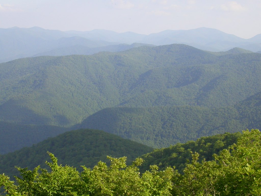
Located in Macon County just wes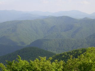 t of Franklin, North Carolina, Wayah Bald surprises visitors with stunning panoramic views of the Great Smoky and Unicoi Mountains above the Nantahala and Little Tennessee River valleys. On a clear day, you can see to Greenville, SC and into Georgia and Tennessee from this awesome vantage.
At 5,342 feet above sea level, this peak in the Nantahala National Forest has been a favorite of visitors for centuries. Legend has it that a Cherokee man climbed this mountain, called wa 'ya meaning wolf, to glean wisdom from the stars and return to teach his grandson. Hernando de Soto is said to have passed through the area in 1540 searching for gold. Naturalist William Bartram traveled through in 1776, and today, hikers following the both the Bartram Trail and the Appalachian Trail are rewarded at the summit with a cool breeze and gorgeous views. During the 1800's and early 1900's locals from Franklin and their city guests gathered here often in the summer to camp, at times numbering so many that Sunday worship services were held.
In 1927, the Forest Service erected a wooden fire tower on the bald. In 1935 the Civilian Conservation Corps (CCC) began construction on a new, 53-foot tower built of quarry stone and oak shakes. After several years of service as a fire tower and public observation deck, the structure suffered water damage and was closed in 1945. The top two stories were removed, and in 1983 a new hemlock-beam and cedar-shake roof structure was added and the tower reopened to the public.
Wayah Bald is considered a heath bald, covered mostly in flowering shrubs and wildflowers. In May and June, the summit provides a breathtaking display of orange, pink, and white azaleas. There is much d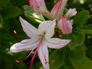 ebate as to what created balds such as this in the Appalachians. Many have offered theories, including fire, drought, overgrazing, and/or insects. Cherokee stories and legends suggest that some balds have existed for a very long time, although many historians and naturalists argue that most were cleared by white settlers for grazing. Today, the Forest Service maintains the bald by selective cutting, allowing azaleas, laurel, rhododendron, and other wildflowers to predominate.
To get to Wayah Bald: From Franklin, drive west on US64 for 3 miles. Turn right onto Old Murphy Road (Old US64) at the Wayah Bald sign and go .2 miles to Wayah Road (State Road 1310). Turn left and continue for 9 miles along Wayah Creek to Wayah Gap and Forest Road 69. Wayah Crest Picnic Area will be on your left. Turn right onto FR 69 and drive 4.4 miles to the Wayah Bald parking area.
FR 69 is gravel and curvy, but well-maintained. At about 1.3 miles, you may want to stop and view the Wilson Lick Ranger Station. Built in 1913, this was the first ranger station in the Nantahala National Forest.
At the Wayah Bald parking area, there are pit toilets and a paved path to the obseration tower, as well as a small picnic area.
Be sure to bring your camera.
All photos by Wesley J. Satterwhite
 t of Franklin, North Carolina, Wayah Bald surprises visitors with stunning panoramic views of the Great Smoky and Unicoi Mountains above the Nantahala and Little Tennessee River valleys. On a clear day, you can see to Greenville, SC and into Georgia and Tennessee from this awesome vantage.
At 5,342 feet above sea level, this peak in the Nantahala National Forest has been a favorite of visitors for centuries. Legend has it that a Cherokee man climbed this mountain, called wa 'ya meaning wolf, to glean wisdom from the stars and return to teach his grandson. Hernando de Soto is said to have passed through the area in 1540 searching for gold. Naturalist William Bartram traveled through in 1776, and today, hikers following the both the Bartram Trail and the Appalachian Trail are
 rewarded at the summit with a cool breeze and gorgeous views. During the 1800's and early 1900's locals from Franklin and their city guests gathered here often in the summer to camp, at times numbering so many that Sunday worship services were held.
In 1927, the Forest Service erected a wooden fire tower on the bald. In 1935 the Civilian Conservation Corps (CCC) began construction on a new, 53-foot tower built of quarry stone and oak shakes. After several years of service as a fire tower and public observation deck, the structure suffered water damage and was closed in 1945. The top two stories were removed, and in 1983 a new hemlock-beam and cedar-shake roof structure was added and the tower reopened to the public.
Wayah Bald is considered a heath bald, covered mostly in flowering shrubs and wildflowers. In May and June, the summit provides a breathtaking display of orange, pink, and white azaleas. There is much d
 ebate as to what created balds such as this in the Appalachians. Many have offered theories, including fire, drought, overgrazing, and/or insects. Cherokee stories and legends suggest that some balds have existed for a very long time, although many historians and naturalists argue that most were cleared by white settlers for grazing. Today, the Forest Service maintains the bald by selective cutting, allowing azaleas, laurel, rhododendron, and other wildflowers to predominate.
To get to Wayah Bald: From Franklin, drive west on US64 for 3 miles. Turn right onto Old Murphy Road (Old US64) at the Wayah Bald sign and go .2 miles to Wayah Road (State Road 1310). Turn left and continue for 9 miles along Wayah Creek to Wayah Gap and Forest Road 69. Wayah Crest Picnic Area will be on your left. Turn right onto FR 69 and drive 4.4 miles to the Wayah Bald parking area.
FR 69 is gravel and curvy, but well-maintained. At about 1.3 miles, you may want to stop and view the Wilson Lick Ranger Station. Built in 1913, this was the first ranger station in the Nantahala National Forest.
At the Wayah Bald parking area, there are pit toilets and a paved path to the obseration tower, as well as a small picnic area.
Be sure to bring your camera.
All photos by Wesley J. Satterwhite
posted by wesleyjeanne @ 1:24 PM
![]()


1 Comments:
At Tuesday, 13 June, 2006, D L Ennis said…
Wesley, this is such a beautiful area and it's been many years since I have been there; your article makes me want to go now!
Post a Comment
<< Home